With an average of 500 accesses per day, the platform brings together information from all state departments, as well as land data, afforestation, street vendor control and much more.
The State of Vitória, capital of Espírito Santo, was considered the seventh “smartest” city in the country, according to the Ranking Connected Smart Cities 2022, which evaluates the pillars of mobility, environment, entrepreneurship, education, energy, governance, urbanism, technology and innovation, health, safety and economy. However, this position was not enough for the capital of Espírito Santo to accommodate itself, and the new step in search of more connectivity and intelligence in operations was taken with the launch of the new version of GeoWeb Vitória, which has already has more than 8 thousand hits.
Developed in partnership with Image Geosystems, official distributor of Esri – American leader in Geographic Information System (GIS), the platform can be accessed by citizens and brings information from all municipal departments, such as health, education, energy, communication, all in the palm of the citizen's hand.
In its fourth version, with even more functions, the GeoWeb consolidates itself as a highly configurable platform for community engagement. With data made available by all municipal departments, the platform é a true “information hub”, more complete and functional, whether for those who work at the city hall or for those looking to find out more about the municipality’s public services.
"GeoWeb excels in facilitating access to the municipality’s georeferenced information. The new system delivers more content, better organization, faster navigation and better responsiveness. Vitória City Hall is considered a reference in Brazil in the use of geotechnologies for municipal management, offering the population and employees various applications and solutions", account o Lorenzo Pazolini, Mayor of Vitória.
Marcilene Favarato da Costa – spatial database coordinator at Vitória City Hall, says that one of the factors that places Vitória among the 10 most intelligent cities in Brazil is the range of online tools and systems that were developed to help citizens. And access data shows that the target audience is being reached. In less than two months, the new portal received more than 8 thousand views. Today the average is 500 daily accesses, which even helps the city hall to improve each of the applications, according to the population's feedback.
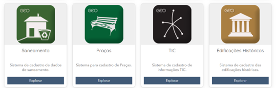
Geoweb has information divided between “external” (for the general public) and “internal” for municipal employees.
Among the external ones are:
● Geoweb Interactive Map: platform that brings together all addresses and public information from all public bodies in the municipality;
● Afforestation: urban afforestation visualization panel, which allows you to check the type and location of each of the more than 34,4 trees planted in the city. With this, the Secretary of the Environment can manage funds more assertively and the population can monitor preservation actions in real time;
● Public works: a complete and interactive map to monitor all public works underway in Vitória;
● Image Bank: a collection of aerial images of the municipality, from 1955 to 2022;
● Land Domain: an integration between the Housing and Finance Departments, with registration of owners, maintenance and management;
● Centro Properties 3D Panel: a complete survey of unused or underused properties in the center, so that it is possible to monitor public housing and redevelopment policies in the central area of the city;
● Street vendors: Complete map, with the location, which products are sold and the validity of the license of all street vendors in the region.
Public servants also have access to data on active debt, risk areas, Civil Defense reports, housing programs, mosquito control, among other relevant information.
"Since its first version, launched in 2005, Geoweb has undergone several changes in order to keep up with global technological developments. Today, we have the most modern and functional equipment available to the population. This project is very relevant for us, as we can apply some of the most modern georeferencing solutions in a system available to all citizens", Says Letícia Mose, specialist at Imagem Geosistemas.
More about Imagem (www.img.com.br): Brazilian company leader in Geographic Intelligence Solutions, founded in 1986, is the official and exclusive distributor of ArcGIS, a platform developed by the North American giant Esri. It supports companies and governments in transforming data into knowledge through technologies that solve business problems. Imagem has a team of 300 professionals, headquartered in São José dos Campos/SP and has commercial offices in São Paulo, Ribeirão Preto, Rio de Janeiro, Brasília, Salvador and Porto Alegre.