 Portuguese
  English
  Spanish
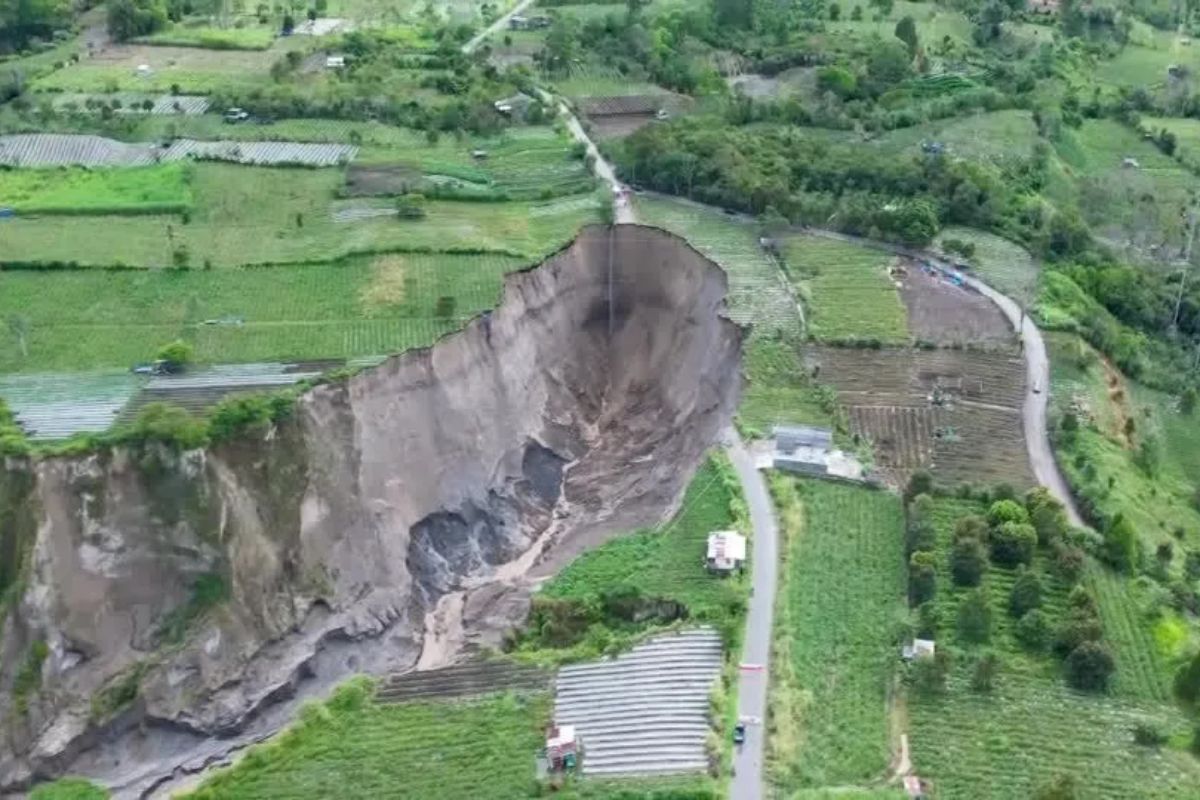
In Central Aceh, a Giant Hole Has Expanded to About Three Hectares, Damaging Crop Areas and Continuing to Advance After Recurring Floods and Landslides. Farmers Report Total Loss of Crops, Edges That Shift in Hours, and Fear of Further Collapses as the Soil Remains Unstable in the Local Rural Area.
The giant hole that opened in Central Aceh, Indonesia, has ceased to be an isolated occurrence and has become a continuous threat to the countryside. In the Ketol district, the crater has encroached on productive areas and transformed what was once farmland into a scene of permanent instability.
The latest aerial images show high, fractured, and active slopes, with cracks crossing the agricultural zone, indicating that the process is not yet complete. From one day to the next, the edge can change position, altering security boundaries, increasing risk for residents, and amplifying the losses for those who depend on the land for their livelihood.
When the Soil Becomes a Risk Border in Ketol
The expansion of the collapsed land in Ketol is not regarded by authorities as a resolved event. The area, estimated at approximately three hectares this year, continues to experience soil movement and signs of instability at the edges. This means that the risk map changes rapidly: what seems stable today may not be so tomorrow.
-
The sugar-energy sector advances with agricultural technology, but agricultural productivity still raises concerns.

-
The eggshell that almost everyone throws away is made up of about 95% calcium carbonate and can help enrich the soil when crushed, slowly releasing nutrients and being reused in home gardens and vegetable patches.

-
This farm in the United States does not use sunlight, does not use soil, and produces 500 times more food per square meter than traditional agriculture: the secret lies in 42,000 LEDs, hydroponics, and a system that recycles even the heat from the lamps.

-
The water that almost everyone throws away after cooking potatoes carries nutrients released during the preparation and can be reused to help in the development of plants when used correctly at the base of gardens and pots, at no additional cost and without changing the routine.


On-site, a safety barrier has already been installed to reduce the approach of residents to the edge of the crater. This measure shows that the problem has exceeded the agricultural damage scale and has entered the realm of civil protection.
It’s not just a loss of productivity, but an abrupt change in land use, with direct impacts on rural routines and daily safety.
Why the Giant Hole Continues to Grow After the Floods
Geological assessments indicate a critical combination: the presence of tuff and sand in the subsoil, materials that easily absorb groundwater and lose stability when saturated. Practically speaking, this favors sudden landslides on the slopes, especially when the terrain has already been weakened by previous erosion and displacement events.
After mass flooding at the end of 2025, the expansion accelerated, according to local authorities. This sequence aligns with scenarios of progressive collapse: more infiltrated water increases internal soil pressure and reduces the resistance of layers, creating space for new ruptures.
The giant hole, in this context, does not “move” by chance; it responds to an active geological system as long as the water flow is not controlled.
Who Lost, How Much Was Lost, and What Cannot Be Recovered
At the center of the problem are farming families who have seen productive areas disappear in a short time. Sumiati, a chili pepper producer, reported destruction of her crop and uncertainty about the next planting cycle.
When the economic base relies on the harvest, losing the soil means losing income, planning, and the ability to restart immediately.
Another farmer, Suprapto, described a shift of several meters at the edge in a single day, even with a safety barrier in place. This type of sudden advancement erodes any predictability in the field: there is no agricultural calendar that can withstand when the very land shifts position within hours.
Besides the direct damage, the invisible cost of waiting for public response, compensation, and minimal reconstruction of rural activity increases.
What the Public Authorities Indicate and Where the Response Limit Lies
The Central Aceh administration reported that the data on agricultural losses have been sent to the central government. This movement is relevant for paving the way for compensation measures and possible emergency support, but it does not resolve the technical core of the problem: without hydrological stabilization and continuous monitoring, the crater may continue to advance.
Experts’ assessments are also aligned on this point: the behavior is similar to that of an expanding crater and is likely to persist if the water flow remains disorganized.
Sending reports is an administrative step; containing the progression requires engineering response and risk management in the territory. Between paperwork and the field, the response time can determine how much of the rural area will still be preserved.
What May Happen Going Forward if Nothing Changes
If the current dynamics continue, the most likely scenario is intermittent expansion: periods of apparent stability, followed by new localized collapses.
This pattern is dangerous because it induces a sense of normalcy in short windows, while the internal structure of the soil is still compromised. In such areas, the edge of the crater tends to be the zone of greatest unpredictability.
The domino effect on the local economy also increases: less cultivable area, more uncertainty for planting, reduced income, and pressure for families to relocate.
The giant hole ceases to be a geographic point and becomes a long-term social problem, impacting work, income, and permanence in the countryside.
For this reason, the discussion is no longer just “how much has opened,” but “how much more can open” if water management does not become an immediate priority.
The case of Aceh shows how a geological event can quickly transform into an agricultural and social crisis when fragile soil, excess water, and slow response come together.
The crater has already swallowed up crops, advanced at an unusual pace, and keeps farmers caught between immediate loss and uncertain future. The central point now is clear: without control of the water flow and continuous technical management, the trend is for new losses.


-

-

-

-

8 pessoas reagiram a isso.