 Portuguese
  English
  Spanish
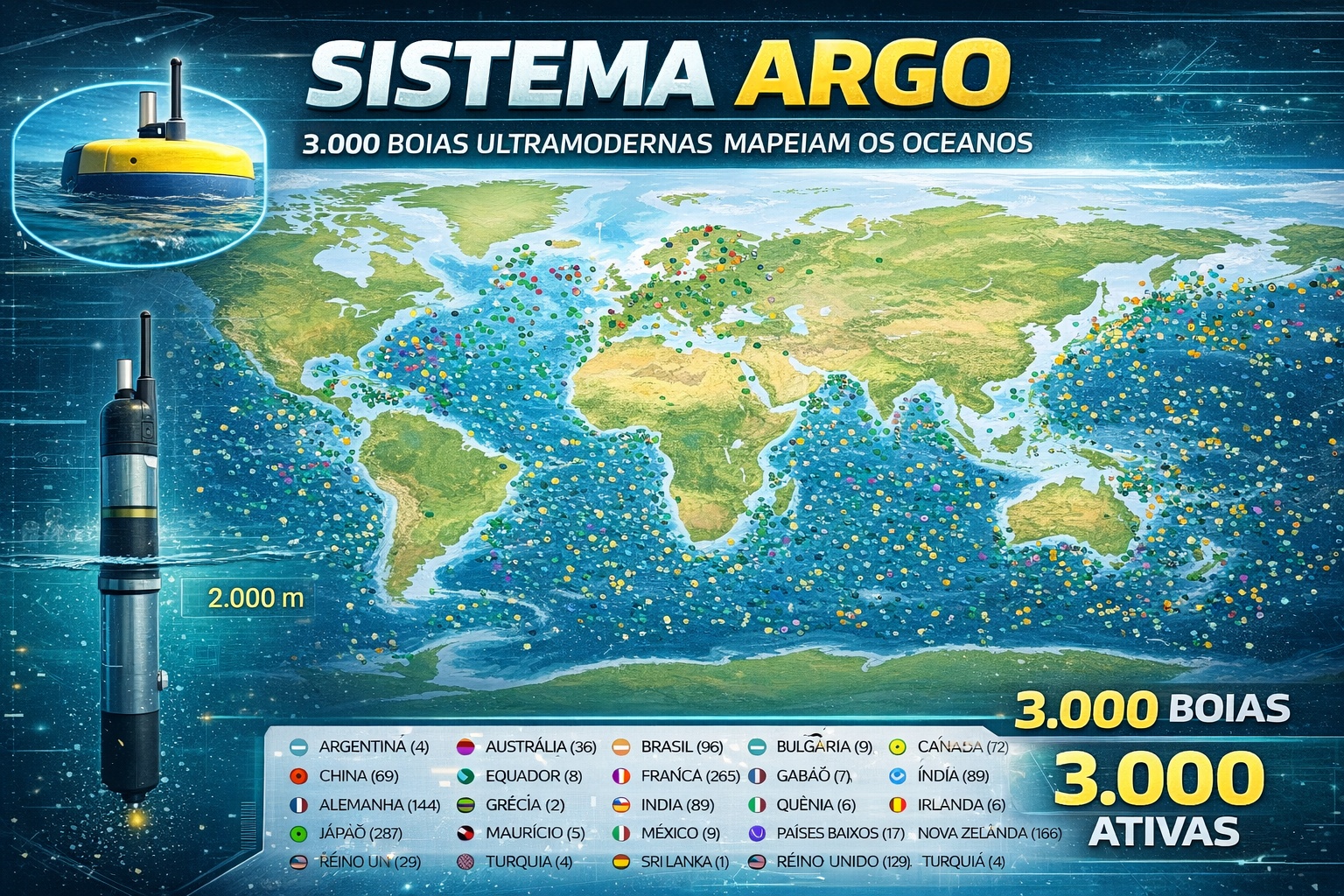


More Than 3,000 Argo Buoys Dive to 2,000 M and Monitor 90% of Ocean Heat, Scientific Basis of Global Climate Change.
When it comes to climate change, the most common image involves atmospheric thermometers, heat waves, and air temperature records. However, most of the global warming is not happening in the atmosphere. According to data compiled by organizations such as NOAA and the IPCC, more than 90% of the excess heat generated by climate warming is absorbed by the oceans.
It is in this scenario that the international Argo program operates, almost invisibly. Created in the early 2000s by a global scientific consortium, the system currently maintains more than 3,000 autonomous buoys distributed across all the oceans of the planet. These devices periodically dive to depths of 2,000 meters to measure water temperature and salinity, transmitting the data via satellite.
This is one of the most important and least known scientific infrastructures on Earth.
-
Motorola launched the Signature with a gold seal from DxOMark, tying with the iPhone 17 Pro in camera performance, Snapdragon 8 Gen 5 that surpassed 3 million in benchmarks, and a zoom that impresses even at night.

-
Satellites reveal beneath the Sahara a giant river buried for thousands of kilometers: study shows that the largest hot desert on the planet was once traversed by a river system comparable to the largest on Earth.

-
Scientists have captured something never seen in space: newly born stars are creating gigantic rings of light a thousand times larger than the distance between the Earth and the Sun, and this changes everything we knew about stellar birth.

-
Geologists find traces of a continent that disappeared 155 million years ago after separating from Australia and reveal that it did not sink, but broke into fragments scattered across Southeast Asia.

How The Argo System Works And Why It Is Strategic
Each Argo buoy is a floating device equipped with oceanographic sensors and a satellite communication system. The operational cycle is relatively simple but technologically sophisticated.
The buoy drifts at the surface for a few hours transmitting data. It then adjusts its internal density and slowly sinks to about 2,000 meters. It remains at this depth for days, tracking deep ocean currents. Afterward, it begins a gradual ascent, recording vertical profiles of temperature and salinity along the water column.
Upon returning to the surface, it sends the information to international data centers before repeating the cycle.
Each unit performs this process approximately every 10 days. The data is made openly available to researchers worldwide.
The Scientific Importance Of Ocean Monitoring
Before Argo, ocean temperature monitoring primarily relied on ships and sporadic measurements, which limited global coverage and data frequency.
With the progressive deployment of the network since 2000, climate science began to rely on systematic and standardized observations on a planetary scale.
Measuring ocean heat content has become one of the most robust indicators of global warming, as water stores thermal energy far more efficiently than air.
The oceans serve as a massive thermal buffer for the planet. Without this heat absorption, the increase in atmospheric temperature would be much faster and more intense.
In addition to temperature, the salinity measured by the buoys helps understand patterns of ocean circulation and the global hydrological cycle.
Global Scale And International Cooperation
The Argo program is coordinated by various international agencies, including NOAA (United States), IFREMER (France), CSIRO (Australia), and oceanographic institutes from dozens of countries.
More than 30 nations contribute funding, deployment, and maintenance of the buoys.
The distribution covers practically all the oceans, including remote areas of the South Pacific and the Southern Ocean. Since its implementation, millions of oceanographic profiles have already been collected.
The impact goes beyond climatology. The data feeds weather forecasting models, studies on ocean currents, monitoring phenomena like El Niño and La Niña, and research on ocean acidification.
Technical Limitations And Evolution Of The System
Although robust, the system has limitations. The standard depth of 2,000 meters covers most of the upper ocean layer, but does not reach deeper abyssal regions.
To expand monitoring capability, researchers developed the so-called “Deep Argo,” an advanced version capable of reaching up to 6,000 meters.
There are also specialized versions to measure biogeochemical parameters, such as dissolved oxygen and pH.
Another challenge is maintaining the network. Buoys have a limited lifespan, usually between four and five years, requiring constant replacement.
Despite this, the system maintains relatively stable coverage since the mid-2000s.
The Ocean As An Invisible Climate Regulator
Recent studies show that ocean heat content continues to increase year after year. This energy accumulation influences the intensification of tropical storms, sea level rise due to thermal expansion, and changes in global circulation.
The increase in water temperature also affects marine ecosystems, including coral reefs and food chains.
Without continuous and reliable data, it would be impossible to quantify these changes accurately. The Argo network has transformed the ocean into a global laboratory monitored in near real-time.
The Silent Infrastructure That Sustains Global Decisions
Governments and international institutions use Argo data to inform climate policies and international agreements.
Models used by the IPCC heavily rely on these measurements. The network operates discreetly, without visible monumental structures, but with profound scientific impact.
While climate debates take place in international conferences, thousands of devices keep diving and surfacing, recording the thermal pulse of the planet.
At 2,000 meters deep, far from the surface and public attention, most of the Earth’s excess heat is being absorbed and monitored.
Understanding this dynamic relies on an oceanic infrastructure that operates quietly but with technical precision.
The Argo system demonstrates that global climate monitoring is not based solely on satellites and ground weather stations. It fundamentally depends on a submerged network that has transformed the oceans into the planet’s primary thermometer.


É maravilhoso este trabalho científico.