 Portuguese
  English
  Spanish
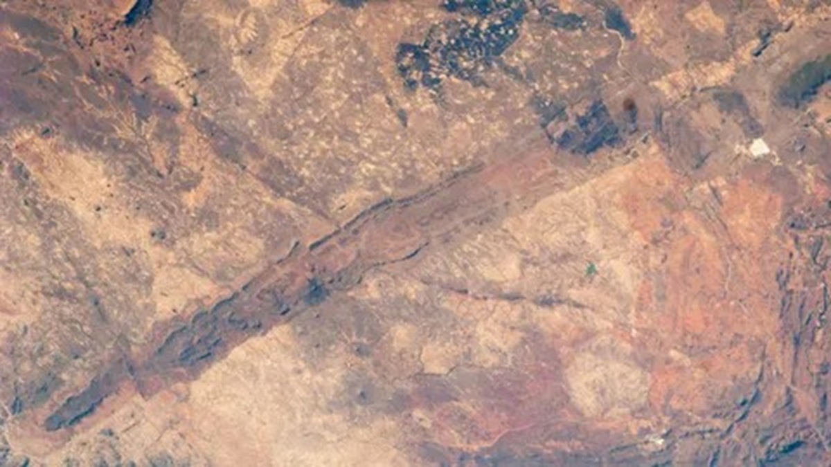
Captured Image From Space Highlights The Hidden Beauty Of The “Geological Wonder” Of 2.5 Billion Years Of Zimbabwe, Formation About 550 Kilometers Long, Up To 13 Kilometers Wide And Hills Reaching 450 Meters Above The Plateaus.
An astronaut recorded from space the southern end of the Great Dyke of Zimbabwe, a magma structure about 550 kilometers long and up to 13 kilometers wide, formed approximately 2.5 billion years ago and rich in valuable minerals.
The image reveals the hidden beauty of the “geological wonder” of 2.5 billion years of Zimbabwe, showing the southernmost part of the formation, located about 125 km from Bulawayo. The photograph highlights the size and configuration of the extensive rock layer.
The Great Dyke runs through the central region of the country, from areas near the capital Harare in the northeast to the vicinity of Bulawayo in the southwest. Its width varies between 3 and 13 kilometers, with hills reaching up to 450 meters above the surrounding plateaus.
-
Motorola launched the Signature with a gold seal from DxOMark, tying with the iPhone 17 Pro in camera performance, Snapdragon 8 Gen 5 that surpassed 3 million in benchmarks, and a zoom that impresses even at night.

-
Satellites reveal beneath the Sahara a giant river buried for thousands of kilometers: study shows that the largest hot desert on the planet was once traversed by a river system comparable to the largest on Earth.

-
Scientists have captured something never seen in space: newly born stars are creating gigantic rings of light a thousand times larger than the distance between the Earth and the Sun, and this changes everything we knew about stellar birth.

-
Geologists find traces of a continent that disappeared 155 million years ago after separating from Australia and reveal that it did not sink, but broke into fragments scattered across Southeast Asia.

According to NASA’s Earth Observatory, despite its name, the structure is not a dyke. It is a lopolith, a formation that develops parallel to existing rock layers, having a flatter, lenticular shape, similar to a saucer.
The Hidden Beauty Of The “Geological Wonder” Of 2.5 Billion Years Of Zimbabwe Seen From Space
The astronaut’s photo highlights the southern end of the structure. The record enhances the visual understanding of the Great Dyke of Zimbabwe, emphasizing its geographic and geological dimension within the national territory.
In 1983, astronauts aboard the Challenger space shuttle also captured an image of the southern half of the formation. Later, in 2003, NASA’s Terra satellite photographed the entire extent of the lopolith, covering approximately 550 kilometers.
The 2003 record presented the complete structure viewed from space, allowing for observation of its continuity along central Zimbabwe. The image highlighted the alignment of the formation in relation to the surrounding urban areas and plateaus.

Geological Formation With 2.5 Billion Years
Geologists estimate that the lopolith formed about 2.5 billion years ago. The process occurred when magma from the Earth’s mantle gradually rose through faults in the tectonic plates.
This data indicates that the Great Dyke has existed for more than half of the estimated history of the Earth, calculated at approximately 4.5 billion years. The ancientness of the structure reinforces its relevance within the geological record of the planet.
The magma that gave rise to the lopolith was rich in minerals that normally remain deep within the Earth’s crust. The ascent of this material resulted in the concentration of various mineral resources along the formation.
According to the Geological Survey of Zimbabwe, the Great Dyke is believed to be the longest continuous igneous intrusion anywhere on Earth. This classification refers to elevated structures formed by magmatic rock.
Valuable Minerals And Mining Activity
The presence of valuable minerals has turned the area into a hotspot for intense mining activity. Currently, there are at least half a dozen large mines distributed along the extent of the lopolith.
According to Mining Zimbabwe magazine, these operations exploit different resources present in the formation. The Earth Observatory reports that the Great Dyke concentrates metals such as gold, nickel, copper, titanium, iron, vanadium, and tin.
Among the resources, vast deposits of platinum stand out. Together, these deposits are considered the third largest of their kind on Earth, according to Mining Zimbabwe.
The formation is also known for its unusually pure chromite, with high levels of chromium. The element is a key component in the production of stainless steel, reinforcing the economic importance of the structure for Zimbabwe.
Near Harare, the Darwendale project is one example of an undertaking located along the Great Dyke. The concentration of mines underscores the relevance of the formation to the country’s mineral sector.
Economic Impact And Cultural Relevance
In addition to metals, the Great Dyke is rich in rocks used for sculpture. Local artist Michael Nyakusvora described the region as a paradise for artists, comparing it to Greek marble quarries.
The mineral diversity and availability of materials for sculpture contribute to various economic activities associated with the formation. The structure combines industrial exploitation and artistic production within the same territory.
According to Mining Zimbabwe, the Great Dyke of Zimbabwe is more than just a line on the map. The publication describes it as a lifeline for economic opportunities and a geological wonder.
The combination of an estimated age of 2.5 billion years, an extension of about 550 kilometers, and a concentration of strategic minerals has solidified the Great Dyke as a central element in the landscape and economy of the country.
The astronaut’s photo, along with the Challenger records in 1983 and the Terra satellite in 2003, enhances the international visibility of the structure. The space image reinforces the physical and historical dimension of the formation in Zimbabwe’s territory.
This article was prepared based on information from NASA’s Earth Observatory, the Geological Survey of Zimbabwe, Mining Zimbabwe magazine, and photographic records from the Challenger space shuttle and NASA’s Terra satellite.


-

-

-

4 pessoas reagiram a isso.