 Portuguese
  English
  Spanish
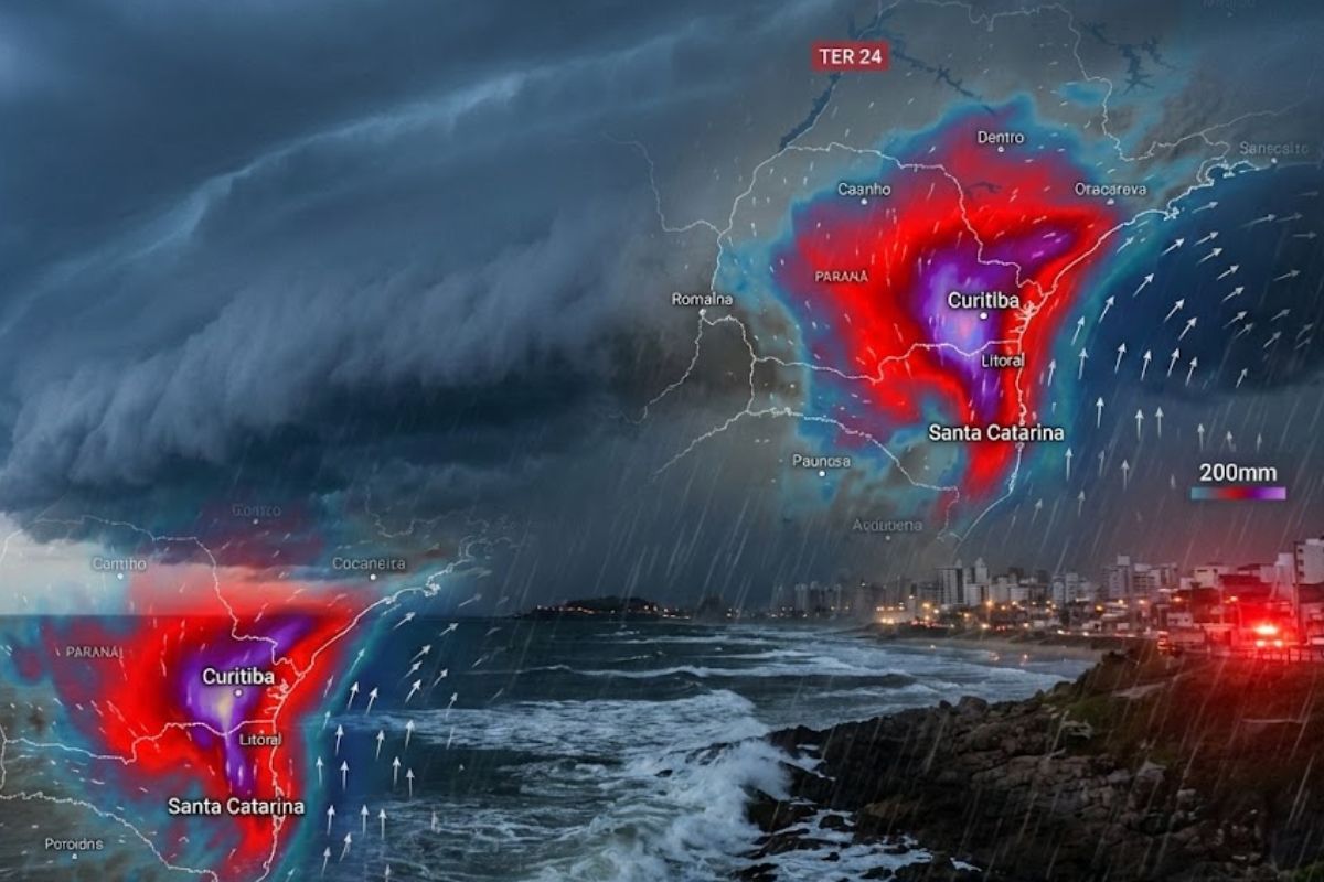
According to Meteored’s Forecast, The Cold Front Begins to Act on Tuesday and Advances Throughout the Day, First with Heavy Rain in Rio Grande do Sul and Later in Santa Catarina and Paraná. By Wednesday, East Paraná and Northern Coastal Santa Catarina Concentrate the Risk of Flooding, Full Rivers, and Landslides.
The cold front expected to start acting on Tuesday (24) changes the weather pattern in Brazil by reorganizing wind circulation and moisture availability, with potential for intense rain and storms, especially in the South. Before its arrival, the trend is for more stable weather in parts of the country, with predominance of dry conditions.
The projection indicates a scenario that combines gradual displacement of the system throughout the day and increasing instability, with volumes that may concentrate in specific areas. In two sections of the South, the warning signal strengthens: the eastern part of Paraná (from the coastline to Greater Curitiba) and Northern Coastal Santa Catarina, where rainfall may reach high accumulations and cause disruptions.
Tuesday (24): When The Cold Front Begins to Redefine Instability in the South

On Tuesday (24), the cold front starts to move and should already provoke locally strong rainfall.
-
Motorola launched the Signature with a gold seal from DxOMark, tying with the iPhone 17 Pro in camera performance, Snapdragon 8 Gen 5 that surpassed 3 million in benchmarks, and a zoom that impresses even at night.

-
Satellites reveal beneath the Sahara a giant river buried for thousands of kilometers: study shows that the largest hot desert on the planet was once traversed by a river system comparable to the largest on Earth.

-
Scientists have captured something never seen in space: newly born stars are creating gigantic rings of light a thousand times larger than the distance between the Earth and the Sun, and this changes everything we knew about stellar birth.

-
Geologists find traces of a continent that disappeared 155 million years ago after separating from Australia and reveal that it did not sink, but broke into fragments scattered across Southeast Asia.

The forecast indicates that throughout the day, instability will expand in area and intensity, with greater potential for storms as the system gradually advances.
Rio Grande do Sul is likely to be the first state to feel the effects in the morning.
Then, in the afternoon, instability spreads throughout the Southern region, reaching Santa Catarina and subsequently Paraná, following a pattern of progression that keeps the weather “changing” continuously throughout the day.
Wednesday (25): The Focus of Rain Shifts, But the Risk Remains High
On Wednesday (25), the cold front advances towards areas further north in the country. In this movement, the forecast indicates a decrease in rainfall intensity in the Gaucho territory, while Santa Catarina and Paraná will continue to experience intense rain, maintaining high risk of disruptions.
This detail is important because the feeling of “the worst has passed” does not always accompany the system’s displacement.
In practical terms, rainfall may decrease in one area and intensify in another, which keeps necessary attention, especially in areas where topography, urbanization, and soil saturation increase vulnerability to impacts.
Where Up to 200 mm May Fall: The Two Most Sensitive Areas and What This Number Means in Practice
By the end of Wednesday (25), the highest volumes may concentrate in specific points in the South, particularly in eastern Paraná, from the coastline to the Metropolitan Region of Curitiba, and Northern Coastal Santa Catarina. In these areas, accumulations may reach 200 mm, increasing the risk of impacts associated with heavy rainfall.
When the forecast mentions 200 mm, it describes a rainfall scenario that, if concentrated in a short period, significantly raises the chance of flooding and overflow.
This is where the cascading effects come into play: overloaded urban drainage, rivers and streams rising quickly, and slopes responding to the combination of persistent water and saturated soil, with real threat of landslides in vulnerable areas.
Flooding, Overflowing Rivers, and Landslides: Why the Same Rain Causes Such Different Impacts
During periods of cold front activity, rain can occur in heavy showers or more continuously, and the difference between these patterns changes the type of disruption most likely.
Intense showers favor quick flooding in urban areas, while persistent rain tends to gradually increase the load on rivers, streams, and the soil, raising the chance of overflow and instability on slopes.
In eastern Paraná and Northern Coastal Santa Catarina, the risk grows because there are areas of high density occupation and naturally sensitive zones to excess water.
Additionally, the forecast also acknowledges occasional possibility of hail, a typical element of storms that may appear in a localized manner, without necessarily affecting the entire area under instability.
The Effect Beyond the South: Winds and Moisture Reorganize and Rain Changes Pattern Across the Country
With the passage of the cold front through the South, wind circulation and moisture tend to organize across much of Brazil.
This arrangement favors the formation of rain showers in states in the Central-West, Southeast, and Northeast regions, as well as areas in the North, showing that the impact of the system is not “confined” only to the southern states.
At the same time, not the entire country enters a mode of increased rainfall.
The forecast indicates a reduction in volumes in Acre, Amazonas, Roraima, Amapá, and northern Pará, a behavior associated with Madden-Julian Oscillation, which during this period can inhibit the formation of heavy clouds in these areas, changing the precipitation pattern even with the general reorganization of moisture.
The cold front forecasted for Tuesday (24) concentrates the alert in two areas where rainfall may reach 200 mm: eastern Paraná (from the coastline to Greater Curitiba) and Northern Coastal Santa Catarina.
With the risk of flooding, overflowing rivers, and landslides, the central point is to monitor the evolution of the system throughout Tuesday and Wednesday (25), as instability shifts and impacts may change from neighborhood to neighborhood.
To understand how this may affect real life: in your area, what is the first sign that the rain has exceeded normal levels: the river rising, the street flooding, the hillside “moving”, or the lack of drainage? And do you tend to trust alerts on your phone, radar/local monitoring, or observing the sky and wind?


Seja o primeiro a reagir!