 Portuguese
  English
  Spanish
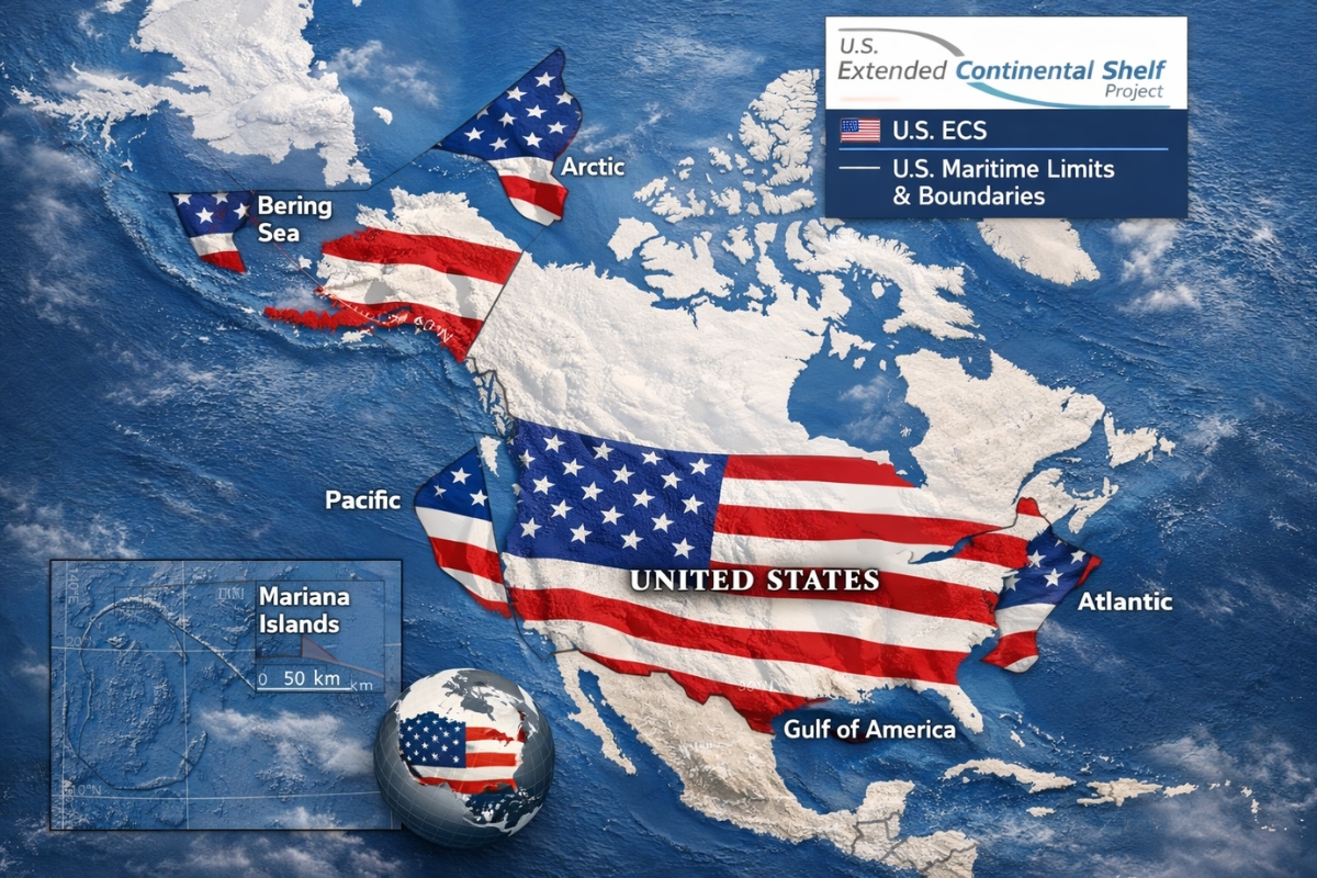
In The Arctic, The United States Established The Delimitation Of An Extended Continental Shelf Up To 350 Nautical Miles To Secure Rights In The Seabed And Subsoil, Provoking Geopolitical Tension And Drawing Attention From Russia, Canada, And Denmark
The dispute for territory does not need a flag planted in the ice to change the game. This time, the “new frontier” was drawn on the ocean floor, in a region where rock, ice, and strategic interest mix.
While the world focuses on other conflicts, Washington has advanced its legal presence under the sea, pushing its sovereign rights hundreds of miles beyond Alaska and approaching areas where Russia and Canada are also seeking to expand their own boundaries.
The detail that caught the most attention is that the measure is not presented as a race for resources but rather as a technical process of maritime law, though the impact can be direct on oil, gas, and strategic minerals.
-
Friends have been building a small “town” for 30 years to grow old together, with compact houses, a common area, nature surrounding it, and a collective life project designed for friendship, coexistence, and simplicity.

-
This small town in Germany created its own currency 24 years ago, today it circulates millions per year, is accepted in over 300 stores, and the German government allowed all of this to happen under one condition.

-
Curitiba is shrinking and is expected to lose 97,000 residents by 2050, while inland cities in Paraná such as Sarandi, Araucária, and Toledo are experiencing accelerated growth that is changing the entire state’s map.

-
Tourists were poisoned on Everest in a million-dollar fraud scheme involving helicopters that diverted over $19 million and shocked international authorities.


The Announcement Of December 19, 2023 That Took The Limit To 350 Nautical Miles In The Arctic
The information was released by CBC, Canadian Public News And Radio Network, highlighting that the United States announced, on December 19, 2023, the limits of its extended continental shelf in seven regions.
The largest movement occurred in the Arctic, where the American claim projects out to about 350 nautical miles and, at some points, can go beyond this mark, practically pushing the area of rights in the seabed far beyond what is near the Alaskan coast.
In geopolitical terms, this expands Washington’s “footprint” under the ocean and encroaches on zones where Russia and Canada are also advancing.

Two Decades Of Discreet Expeditions, Research Ships, And 3D Models Of The Subsoil
Behind the announcement, there is a long and little-visible effort. There were over two decades of scientific expeditions and seabed data collection.
Research ships mapped the underwater terrain and helped build 3D models of the subsoil, aiming to technically support the idea that the “skeleton” of North America extends beneath the polar cap.
In practice, it is science used as a basis for a strategic repositioning, with a direct effect on where a country can claim exclusive rights to exploration on the ocean floor.
A “Kingdom” Submerged The Size Of Two Californias And Almost 1 Million Km² Under New Orbit
The contrast is striking: above, the Arctic looks empty and distant. Below, the map suggests a gigantic area, described as equivalent to the size of two Californias, with an expansion associated with almost 1 million square kilometers of seabed under Washington’s legal orbit.
This type of delimitation does not mean annexation of territory in the classical sense, but redefines who has priority to decide on the exploration of the seabed and subsoil.
And this is where the “board” changes, because invisible lines on the map can open doors to licenses, contracts, and diplomatic disputes.
Oil, Gas, And Critical Minerals Enter The Radar As The Ice Recedes Year After Year
Advisors To Donald Trump Already See The Area As A Possible “Silent Bonanza” Of Oil, Gas, And Strategic Minerals In A Scenario Described As A New Polar Cold War.
Estimates From The U.S. Government Indicate That The Arctic May Hold Tens Of Billions Of Barrels Of Oil, Along With Large Reserves Of Natural Gas And Critical Minerals Linked To Both Military Technology And The Energy Transition, Just In Zones That Connect To This Expansion.
The Factor That Accelerates The Race Is The Physical Environment. With The Ice Receding Year After Year, Routes And Areas Previously Impractical Are Now Being Viewed Differently, Including For Drilling And Logistics.
Trump, Russia, Canada, And Denmark, Why The Invisible Lines May Become Direct Clash
Trump Arrives At This Scenario With A Clear History Of Viewing The Arctic As A Power Piece, Including The Recall Of When He Flirted With The Idea Of Buying Greenland And Positioning Himself As The President Who Would Not Let China Or Russia Advance At The Top Of The World.
Now, With A More Robust “Legal Map,” The United States Can Operate On A Board Where Russia, Canada, And Denmark Are Also Present, All Drawing Increasingly Ambitious Boundaries Under The Ice. Russia, For Example, Has Been Pushing Its Claims For Years, Bringing Its Extended Continental Shelf Closer To Areas Near 200 Miles Linked To Canada And Creating Overlaps Around The North Pole.
The Central Point Is That The Extended Continental Shelf Does Not Transform These Areas Into Traditional “National Territory.” It Grants Exclusive Rights To Whatever Is Extracted From The Seabed And Subsoil, Which Can Allow Concessions, Negotiations With Oil Companies, And Geopolitical Pressure, With The Capacity For Naval Protection If Tensions Rise.
In The End, What Seemed Impossible, To Dominate The Dispute Without Touching The Surface, May Solidify As The Next Frontier Of Power: Appropriating The Ocean’s Subsoil Before The Rest Of The World Treats It As A Strategic Priority.


-

Uma pessoa reagiu a isso.