 Portuguese
  English
  Spanish
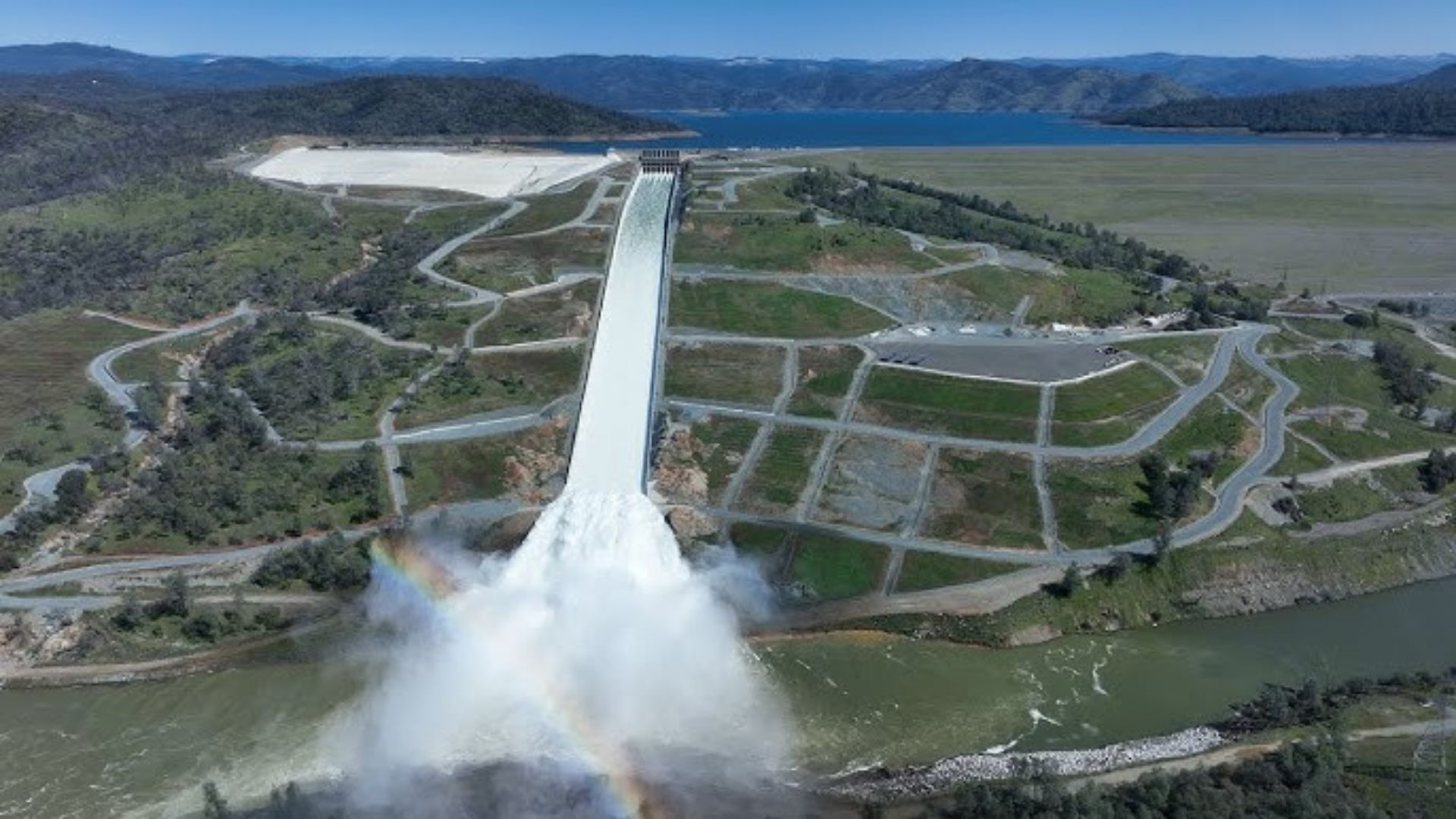
Water Mega-Structure in Northern California Combines 770-Foot Engineering, Trillion-Gallon Reservoir, and Emergency Reconstruction After Partial Collapse in 2017, When Hundreds of Workers Worked Day and Night to Recover 1,800 Meters of Spillway and Reinforce Dam Safety.
The Oroville Dam, in Northern California, is the largest earth-filled structure of its kind in the United States and holds one of the state’s strategic water reserves, with a reservoir that exceeds 1 trillion gallons and plays a central role in flood control and supply.
Completed in 1968, the project sits at the foothills of the Sierra Nevada to regulate the flow of the Feather River, contain rapid floods in the basin, and sustain the operational logic of the State Water Project, the system that moves water from the north to drier and more populated areas.
770-Foot Dam and Trillion-Gallon Reservoir
At 770 feet high from its foundation, Oroville was designed as a rock and earth zoning mass, where layers of materials with different functions work together to resist the continuous pressure from the lake and seasonal variations.
-
Friends have been building a small “town” for 30 years to grow old together, with compact houses, a common area, nature surrounding it, and a collective life project designed for friendship, coexistence, and simplicity.

-
This small town in Germany created its own currency 24 years ago, today it circulates millions per year, is accepted in over 300 stores, and the German government allowed all of this to happen under one condition.

-
Curitiba is shrinking and is expected to lose 97,000 residents by 2050, while inland cities in Paraná such as Sarandi, Araucária, and Toledo are experiencing accelerated growth that is changing the entire state’s map.

-
Tourists were poisoned on Everest in a million-dollar fraud scheme involving helicopters that diverted over $19 million and shocked international authorities.


Besides its size, the actual weight of the project lies in the accumulated water: Lake Oroville stores about 3.5 million acre-feet, a volume equivalent to approximately 1.14 trillion gallons, enough to cushion rainfall peaks and endure drought periods.

To raise the dam in that valley, the engineering had to “split” the river in the operational sense of the worksite, with diversion works and temporary control of the watercourse, while foundations and drainage systems were adjusted to the irregular rock.
From then on, the operation was anchored in two fronts living in constant tension: holding water to ensure future supply and, at the same time, safely releasing flows when storms raise the reservoir level above the planned height.
2017 Crisis and Main Spillway Failure
In early February 2017, a series of storms quickly raised the inflow of water into Lake Oroville and forced operators to heavily use the main spillway, when signs of damage appeared and evolved in just a few days.
The problem became evident on February 7, when significant wear was identified in the concrete-lined channel, allowing water to escape underneath the plates, opening craters, and exposing the foundation to accelerated erosion.
With the lake level rising, operations had to choose between releasing more water through a compromised structure or accepting the approach of the limit that triggers the emergency spillway, used for the first time since its inauguration.

On February 11, water began to overflow the emergency spillway, and the next day, local authorities ordered evacuations in downstream areas due to the risk of erosion advancing toward the “lip” of the concrete structure.
Reconstruction of 1,800 Meters and Mobilization of 600 Workers
After the crisis, California initiated a repair and reconstruction program involving both the main spillway and associated structures, focusing on removing compromised sections, stabilizing the foundation, and resurfacing to withstand high discharges.
The size of the critical section rebuilt is often summarized as about 1,800 meters of channel, a figure that reflects the scale of the work on steep slopes, heavy machinery operations, concrete removal, and base reconstruction.
In 2017, the timeline was treated as a race against the upcoming rainy season, and the project mobilized over 600 workers to deliver the essential phase in just a few months, with shifts keeping the worksite active day and night.
Technical reports and work records describe the combination of demolition, excavation, and layered reconstruction, including roller-compacted concrete and structural concrete, as well as drainage to reduce pressure under the channel and protect the lining.
With the rehabilitation, attention also turned to the hydrodynamic behavior at the lower end, where energy dissipators and erosion protections are crucial to prevent the force of the water, at the end of the ramp, from attacking the foundation again.
The phased reconstruction allowed repositioning the spillway into operation before the next winter, while supplementary works continued until the completion of the set of improvements, in an effort that extended over the 2017–2018 cycle.
Water Safety and Continuous Monitoring
The 2017 episode showed that a dam can remain stable as a main mass and still have its overall safety threatened by peripheral elements, such as spillways, which must operate under extreme loads precisely when they fail.
Today, the routine depends on inspections, instrumentation, and discharge protocols to reconcile supply, energy, and flood control, because the same water that ensures provision also imposes permanent pressure on the infrastructure.
Retelling the story of a project designed to dominate a valley and regulate a river, the question that arises is direct: after 2017, which signals and metrics should weigh more in the decision to release water early, even if that reduces the supply for drought?


-

-

-

-

5 pessoas reagiram a isso.