 Portuguese
  English
  Spanish
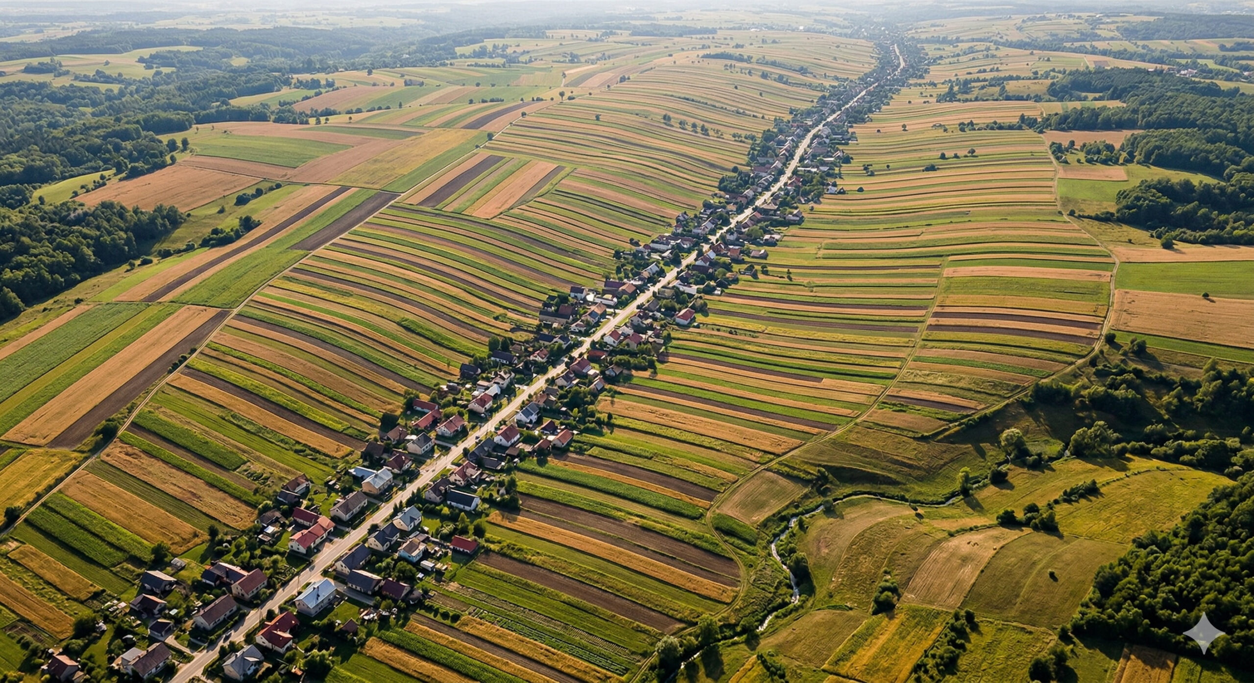
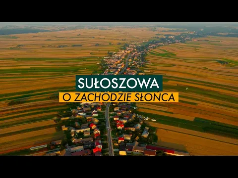
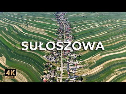
Village in Poland Concentrates Nearly 6,000 Residents Along a 9 km Street and Impresses with Unique Agricultural Strips Seen from Above.
In 2023, aerial images of the village of Sułoszowa, located in southern Poland, near the city of Kraków, gained international attention by exposing an extremely unusual pattern of land occupation. Widely shared photographs showed a continuous sequence of houses aligned along a single road, accompanied by long parallel agricultural strips extending behind each residence.
According to an official report from the Gmina of Sułoszowa, the municipality had 5,705 inhabitants at the end of 2022, a number that in viral content is often rounded to about 6,000. However, this population figure is only part of the uniqueness of the place. What really stands out is how this population is distributed: predominantly concentrated along a main road that extends for over 9 kilometers.
This model of land organization, known in Central Europe as “ulicówka”, represents a historical type of linear rural settlement that, although common in past periods, today survives in few locations with this level of preservation. According to the local administration of Sułoszowa itself, the village is among the longest ulicówki in Poland, with a linear urban layout that exceeds 9 kilometers in length.
-
Millionaires flee to Florida and create chaos at the marinas: megayachts of Bezos, Brin, and Zuckerberg don’t fit, spots disappear, cost up to $500,000 a year, and it has already turned into a legal battle for space.

-
A Globo actor lives on a farm the size of 300 football fields in Teresópolis, where he produces cheese, honey, and organic chocolate, and has already planted 20,000 native trees.
-
This simple tool eliminates the need for a plumb line with each row, speeds up brick laying by up to 40%, and any laborer can align the wall by themselves, but almost no one in Brazil uses it on construction sites.

-
Won R$ 72 million in the British lottery, but lost it all for not claiming: October ticket in Bexley was forgotten, the 180-day deadline passed, and the fortune will fund local community projects in London.
Unique Street of Nearly 9 km Concentrates Residences and Defines the Entire Urban Structure of the Village
The urban layout of Sułoszowa is defined by a single long and continuous main road, which serves as the structuring axis of the entire village. Along this road, houses are built side by side, forming a practically uninterrupted sequence of residences over several kilometers.
How the street is divided:
- the residences face directly onto the main road
- access to the properties occurs from the front
- land occupation develops along a continuous line
Although there are small branches and secondary areas within the gmina, the dominant pattern remains concentrated on this central road, which organizes both mobility and the distribution of daily activities.
Narrow and Parallel Agricultural Strips Create One of the Most Unusual Visual Patterns in Rural Europe
One of the most striking elements of Sułoszowa is located just behind the houses: long strips of agricultural land that extend for hundreds of meters, forming a highly organized parallel pattern.
These plots are narrow and aligned side by side, creating a visual mosaic that becomes particularly impressive when viewed from above. In aerial or satellite images, the territory takes on an appearance reminiscent of organized brush strokes or colored strips arranged in sequence.
This pattern is not random. It results from a historical model of land division in which each family received a continuous strip of cultivation directly connected to their residence. This configuration allowed direct access to the fields without the need for additional travel, while also ensuring a more equitable division of the available territory.
The result is a highly functional landscape that also stands out for its visual impact.
Medieval Origin of the “ulicówka” Model Explains the Logic Behind the Linear Organization
The pattern observed in Sułoszowa has deep historical roots. The “ulicówka” model emerged during the Middle Ages as an efficient way to organize rural settlements in regions of Central and Eastern Europe.
This system was developed to solve practical problems related to land distribution and access to resources. By aligning houses along a single road and distributing agricultural areas behind each residence, the model ensured that all residents had:
- direct access to the road
- proximity to their cultivation areas
- balanced participation in territorial division
Over the centuries, many of these settlements have been transformed or replaced by more complex urban models. However, Sułoszowa has preserved this structure, becoming one of the most complete examples of this type of organization still in operation.
Integration Between Housing and Agricultural Production Reduces Travel and Maintains Functional Logic
One of the most relevant aspects of this model is the direct integration between residence and productive area. In Sułoszowa, the farmer does not need to travel long distances to access their crop, as it literally starts in the backyard of their house.
This proximity creates a functional relationship between housing and work, reducing the need for additional infrastructure and simplifying the logistics of agricultural activities. This type of organization also influences the local pace of life, as productive activities are directly connected to the domestic space.

This integration is considered one of the factors that contributed to the longevity of the model, even in the face of urban transformations that have occurred over the centuries.
Proximity to Ojców National Park Boosts Tourism and Complements the Local Economy
Despite the strong presence of agriculture, the economy of Sułoszowa is not limited to rural production. The location near the Ojców National Park, one of the most well-known natural areas in Poland, contributes to the development of tourism in the region.
The park features geological formations, trails, and historical sites, such as the Pieskowa Skała Castle, which attract visitors throughout the year. This tourist flow generates an additional source of income for the local community and increases interest in the village.
The combination of natural landscape and unusual territorial organization has transformed Sułoszowa into a point of curiosity not only for tourists but also for researchers and urban planners.
Linear Structure Influences Mobility, Trade, and Social Organization of the Village
The way the village is organized directly impacts the daily dynamics of its residents. With practically all residences distributed along a single road, mobility and the availability of services follow the same logic.

Trade, for example, tends to concentrate along the main road, as do schools, public services, and social meeting points. This linearity creates an urban model different from the conventional pattern, where centrality is replaced by a distribution along an axis.
This type of organization can reduce internal travel and facilitate access to services, but it also imposes limitations in terms of urban expansion.
Viralization of Images Placed Sułoszowa on the Global Radar of Urbanism and Geography
The aerial images that circulated in 2023 were crucial in transforming Sułoszowa into a global phenomenon. The unusual visual pattern caught the attention not only of the curious but also of experts in urbanism, geography, and land planning.
The village began to be studied as an example of:
- preserved historical land organization
- efficient use of rural space
- integration between housing and production
This international exposure increased interest in the region and reinforced its relevance as a case study.
The Case of Sułoszowa Shows How Ancient Models Can Still Function in the 21st Century
Even with the advancement of modern urban models, Sułoszowa demonstrates that traditional structures can remain functional when adapted to the local context. The persistence of the “ulicówka” model over centuries highlights its efficiency under certain conditions.
The combination of tradition, functionality, and economic adaptation allows the village to maintain its identity without losing practical viability. This balance between past and present is one of the factors that makes the case relevant in discussions about land planning.
Would You Live in a Town Where Almost the Entire Population Lives Along a Single Street?
The case of Sułoszowa shows that alternative forms of urban organization can exist and function for centuries.
In your view, could this type of model be applied in other regions, or does it only make sense within specific historical contexts? Share your opinion in the comments.


Seja o primeiro a reagir!