 English
  Francês
  Alemão
  Italiano
  Japonês
  Norueguês
  Portuguese
  Spanish
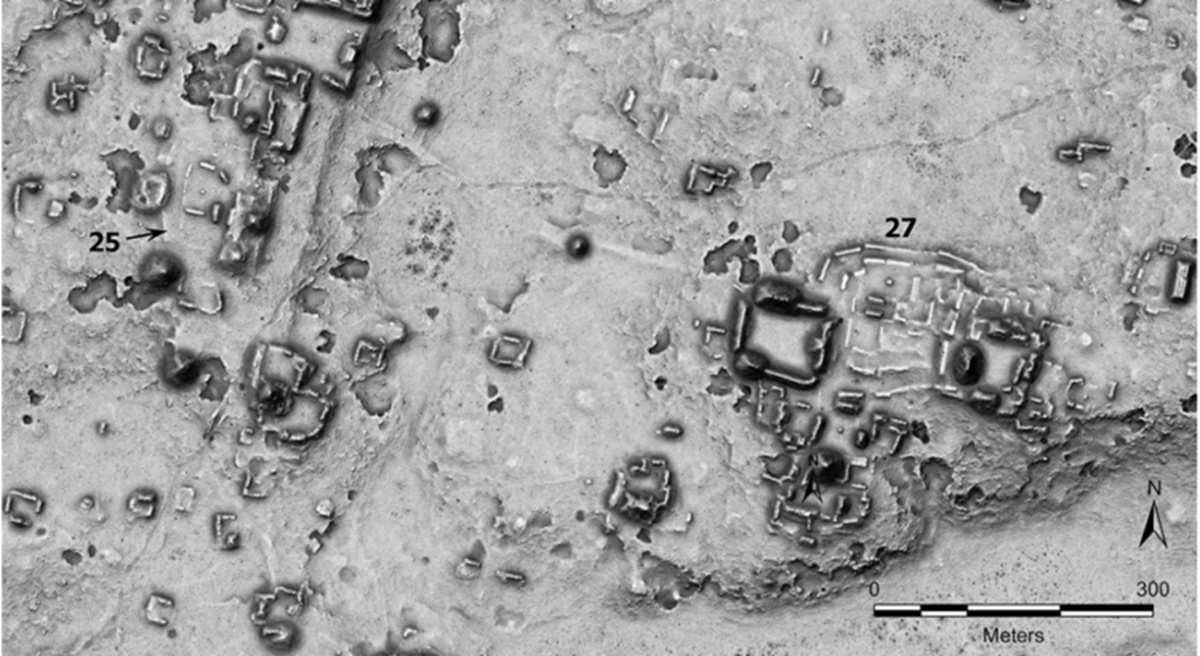
Discrete circles identified in ancient centers of the Mayan civilization, many of them revealed by LiDAR technology, strengthen the hypothesis that these spaces functioned as structured markets, connecting commerce, circulation of goods, social interaction, and even ritual practices in different regions of Yucatán
The mysterious circles identified by archaeologists in the Yucatán Peninsula are opening a new front of understanding about the Mayan civilization by pointing to the existence of structured markets, integrated into the economy, territory, and also social and ritual practices. The discovery, associated with the use of LiDAR technology, reinforces the hypothesis that these spaces played a central role in commercial exchanges and the daily organization of different Mayan centers.
The research was conducted by Ivan Šprajc from the Research Center of the Slovenian Academy of Sciences and Arts, and published in the journal Ancient Mesoamerica.
The study examines architectural complexes found in the lowlands of Yucatán and argues that the shape, distribution, and context of these structures concentrate consistent evidence of their use as markets.
-
Explorers find Roman treasure trapped between rocks on the seabed for nearly 1,600 years and reveal a desperate attempt to hide 53 gold coins during the invasions of the Empire.

-
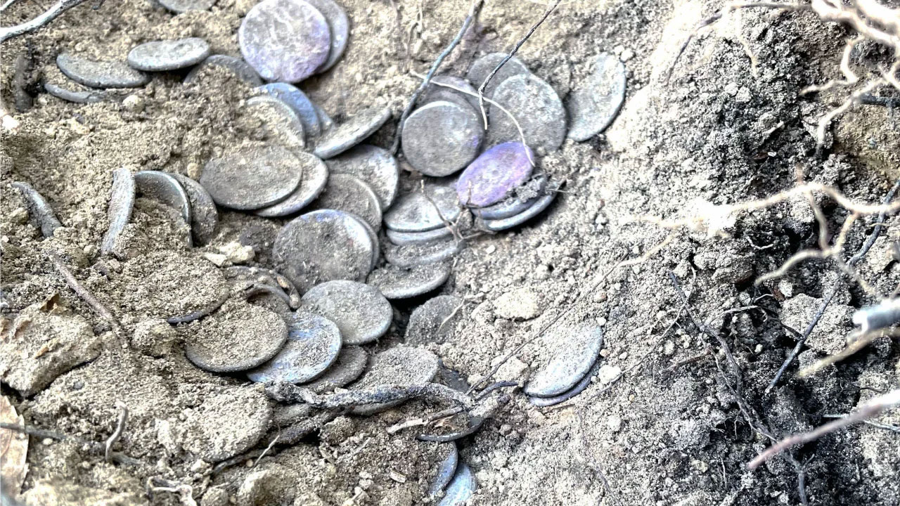
Archaeologists discover Roman vase buried for over 2,000 years with more than 175 intact gold and silver coins, revealing a desperate strategy to protect wealth during the collapse of the Empire.
-
With 241 meters, 48 thousand tons, and a structure designed to accompany aircraft carriers at sea, the Chinese ship that refuels fleets in motion was born to push Beijing away from the coast and has become the hidden gear of its naval projection.

-
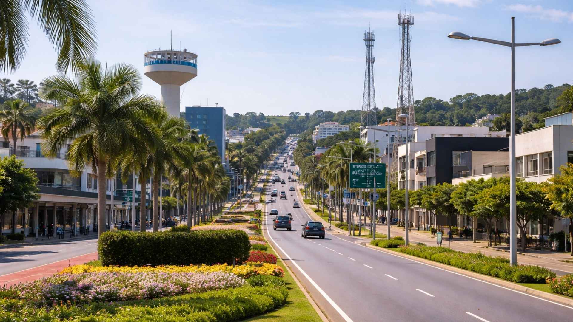
“Discreet” city in the interior of SP stands out among the smartest in Brazil thanks to a national ranking.

Historically, the study of Mayan economies has faced difficulties due to the scarcity of direct evidence about trade spaces. As markets leave few lasting traces, archaeologists often rely on indirect and fragmentary signs to try to reconstruct their existence and functioning.
Circles and platforms reveal a recurring architectural pattern
The complexes analyzed do not stand out for their monumentality, but for a discreet configuration repeated over a vast area of the peninsula. Instead of pyramids or decorated palaces, they consist of low, narrow, and elongated platforms, organized in circles or interwoven rectangles.
According to Šprajc, despite local variations, these structures exhibit remarkable formal consistency. This regularity suggests that they are not random constructions, but spaces planned to fulfill a specific and codified function within Mayan organization.
The data obtained by LiDAR allowed for the identification of at least fifty of these complexes. However, this total is still considered incomplete, as the low height of the structures and the wear caused by erosion make direct observation on the ground difficult.
This limitation helps explain why these architectural sets went unnoticed for so long. Without aerial images and remote sensing resources, many of them remained practically invisible, which reduced the chances of a broader understanding of their distribution and purpose.
Archaeological indications strengthen the hypothesis of Mayan markets
The interpretation of these structures as markets gains strength when the architecture is observed in conjunction with other elements. Some representations associated with these spaces show a diversity of products and participants, including women involved in transactions, something noted as compatible with Mayan market practices of that period.
The very configuration of the complexes also contributes to this reading. In some cases, there are more imposing structures that may have served for the storage of goods or to house authorities responsible for overseeing commerce.
Šprajc also mentions the possibility of auxiliary spaces linked to control or management. This suggests that commercial activities did not occur in an improvised manner, but within an organized logic, with areas designated for different functions within the same complex.
The discoveries made at different sites help to complete this picture. Researchers found fragments of jade, stone working residues, and food remains, indicating the coexistence of activities related to craftsmanship, circulation of goods, and consumption on-site.
These traces expand the understanding of the complexity of these environments. Instead of areas solely dedicated to buying and selling, the spaces seem to have concentrated multiple practices, bringing together production, exchange, and everyday use of different products.
Commerce, ritual, and social life occupied the same space
Another piece of information considered relevant by researchers is the presence of altars and ritual deposits. These elements indicate that markets were not limited to an economic role, but were also connected to symbolic and religious practices.
This overlap of functions suggests a broader conception of space among the Maya. Commerce appeared intertwined with social life and ritual, reinforcing the idea that these complexes played a central role in the dynamics of the communities in which they were embedded.
The reading proposed by the study, therefore, is not limited to identifying areas for the circulation of goods. It points to spaces where different dimensions of collective life coexisted, gathering material exchanges, administration, social interaction, and symbolic manifestations.
Distribution of complexes shows exchange networks on different scales
The geographical location of these complexes is also treated as a key piece to understand their function. Many of them appear in large urban centers, such as Calakmul and Tikal, while others emerge near more modest residential areas, indicating different levels of exchange, from local to regional.
Communication routes played an important role in this network. Some complexes were interconnected by elevated walkways known as sacbeob, and in Ocomtún, one of these routes connects two sectors that contain complexes, facilitating the movement of people and goods.
Access to water also appears as a decisive factor for the functioning of these spaces. Many complexes were identified near reservoirs, rivers, or artificial depressions, a proximity that would ensure supply for the daily activities developed in these environments.
Environmental conditions help explain the concentration of structures in certain areas. In regions with infertile soils and difficult cultivation, the dependence on trade for obtaining agricultural products could be greater, which, according to Šprajc, helps to understand the higher density of complexes in certain points.
The study also associates these spaces with broader commercial axes. By citing the hypothesis of Ruhl and his colleagues about a system linking the Gulf coast to the center of Yucatán, Šprajc connects the complexes to an organized network, influenced by geography, available resources, and social dynamics.
This reading also dialogues with historical data about trade controlled by Chontal merchants, established mainly in the Gulf of Mexico region, especially in what today corresponds to the states of Campeche and Tabasco.
Thus, the circles and other complexes identified by LiDAR are seen as parts of a broader and articulated territorial system of exchanges.


Seja o primeiro a reagir!