 Portuguese
  English
  Spanish
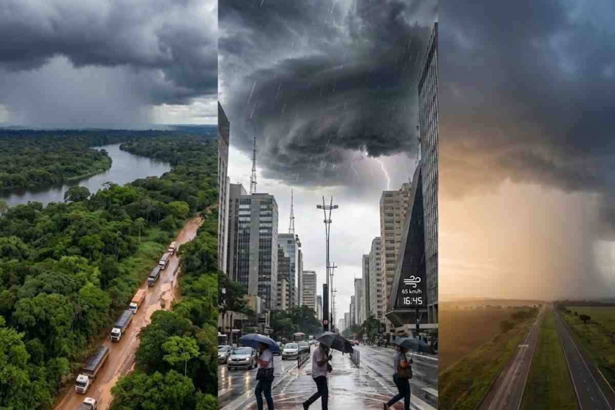


Even Far From The Coast, The Cyclone Still Drives Instabilities And, Added To The Humid Corridor Of The Amazon, Keeps Intense Storms In The Southeast And Center-West, With Gusts Above 60 Km/h, Risk Of Floods, Power Outages And A Cold Front Reinforcing The Turn In The Weather In The Coming Days In Several Urban Areas.
Even though the extratropical cyclone that hit the South has already moved away to the center of the South Atlantic, the Southeast and Center-West remain on alert this Friday for storms, heavy rain and wind gusts above 60 km/h, fueled by the heat wave, high humidity and new atmospheric systems that keep the atmosphere charged in much of the country.
According to meteorologist Aline Tochio, from Climatempo, in an interview with Show da Notícia, the combination of the humid corridor coming from the Amazon and disturbances at mid-levels of the atmosphere should keep the weather unstable throughout the weekend and also starting Monday, Tuesday and Wednesday, when a new cold front should reinforce the rain and the drop in temperature.
Cyclone Moves Away, But The Atmosphere Remains Charged
Aline Tochio explains that the extratropical cyclone no longer directly affects Brazil, as it has shifted to the center of the South Atlantic.
-
Millions of people have been eating yam for centuries without knowing that this humble tuber contains a compound called diosgenin, which scientists have now discovered can improve memory and help control blood sugar levels.

-
Scientists from an international project drill 1,800 meters of ice in Antarctica using hot water and discover details about one of the most intriguing places on planet Earth.

-
Seen from space, a colossal volcano nearly 5,000 meters high in Russia has released 1,600 km of smoke over the Pacific, forming “devil’s horns” of lava and revealing the brutal force of the Ring of Fire.

-
Expedition 501: Scientists drill into the ocean floor and discover a giant reserve of fresh water hidden beneath the sea, extracting nearly 50,000 liters and revealing an invisible system that could reshape the map of water scarcity.


Even so, the effects of this system’s circulation still combine with other phenomena, maintaining the pattern of unstable weather in the Southeast and Center-West and in parts of the North.
According to the meteorologist, there is a corridor of warm and humid winds coming from the Amazon, associated with disturbances at mid-levels of the atmosphere.
This meteorological pattern favors the formation of storm clouds, with the potential for heavy rain, electrical discharges, and strong winds in different states.
Humid Corridor And New Systems Feed Storms
This humid corridor that originates from the Amazon acts like a “road” of humidity, transporting warm and charged air towards the interior of the country.
When this air meets the intense heat typical of this time of year and the disturbances at higher levels, the storm clouds gain strength and spread rapidly.
Aline emphasizes that this is not just a remnant of the cyclone, but several systems acting simultaneously, which explains the persistence of storms even after the departure of the system that caused damage in the South of Brazil.
Southeast And Center-West Feel The Most Intense Effects
In the Southeast and Center-West, the impacts are already strongly felt. In São Paulo state, storm lines cause intense rain and wind gusts in different regions, including the northern part of the state, areas near Campinas, and the interior towards southern Minas Gerais.
In the Center-West, instability spreads across Mato Grosso, Mato Grosso do Sul, and southern Goiás, with the possibility of disruptions in urban areas, such as flooding and power outages.
In the North, southern Amazonas also falls within the area of greatest instability, under the influence of the same humid corridor.
According to Aline Tochio, Rio de Janeiro and Espírito Santo are also at risk of heavy rain, especially between the afternoon and evening, with gusts of wind and electrical discharges.
In Paraná, instabilities are more concentrated in the northern part of the state, keeping the alert for localized storms.
South Has A Short Truce Before The New Cold Front
In southern Brazil, after the severe impacts of the cyclone in Santa Catarina and Rio Grande do Sul, the weekend tends to be calmer in part of the region, with reduced rain and a temporary feeling of improvement.
However, this truce should not last long. Starting Monday, new instabilities coming from Argentina and Paraguay will again affect Rio Grande do Sul and the west of Santa Catarina and Paraná, with the risk of new storms.
On Tuesday, the forecast is for the advancement of a new cold front, reinforcing the rain and causing a more significant drop in temperatures.
According to the meteorologist, the wind is not expected to reach the same intensity observed during the cyclone, but gusts above 60 km/h are already sufficient to cause disruptions, knocking down trees, damaging fragile structures, and causing interruptions in power supply.
Northeast Is An Exception, With Drier Weather And Light Rain
While the Southeast and Center-West face consecutive days of instability, the Northeast is experiencing a different situation.
It is the only region with a more stable scenario during this period, as this is the time of year with the lowest rainfall volume in much of the northeastern interior.
According to Climatempo, the coastal strip may still register quick bursts of rain, interspersed with periods of sunshine.
In contrast, areas of western Bahia, southern Piauí, and Maranhão should see only isolated rains, without large accumulations, maintaining a much less critical situation compared to the rest of the country.
Heat And Muggy Nights Continue In São Paulo And In Areas Of The Southeast And Center-West
In the city of São Paulo, the weather remains muggy. The temperature reached 28 °C this Friday, and the rain that fell in different neighborhoods helped to lower temperatures at times, bringing temporary relief to those who faced the hottest heat throughout the day.
However, the more consistent drop in temperature is not expected to be felt until Wednesday, with the arrival of the new cold front linked to the system advancing through the South.
Until then, the Southeast and Center-West will continue to deal with heat, high humidity, and nights warmer than normal, along with daily risks of storms, especially in the late afternoon and early evening.
With the humid corridor of the Amazon active, new systems arriving and wind gusts that may exceed 60 km/h, experts emphasize the need to follow official alerts and take extra care in areas prone to flooding, flash floods, and falling trees.
In your city, is the weather also as unstable as in the Southeast and Center-West or is the situation there calmer?


Aqui em Paraisopolis Mg (sul de minas) ventos fortíssimos e chuvas intensas mas passageiras. O calor continua…
Aqui na zona da Mata, o tempo de manhã e a tarde calor sufocante e à noite temporais e ventos de 60km por hora e refresca nas madrugadas.A cidade aqui é: Volta Grande _ Minas Gerais.