 Portuguese
  English
  Spanish
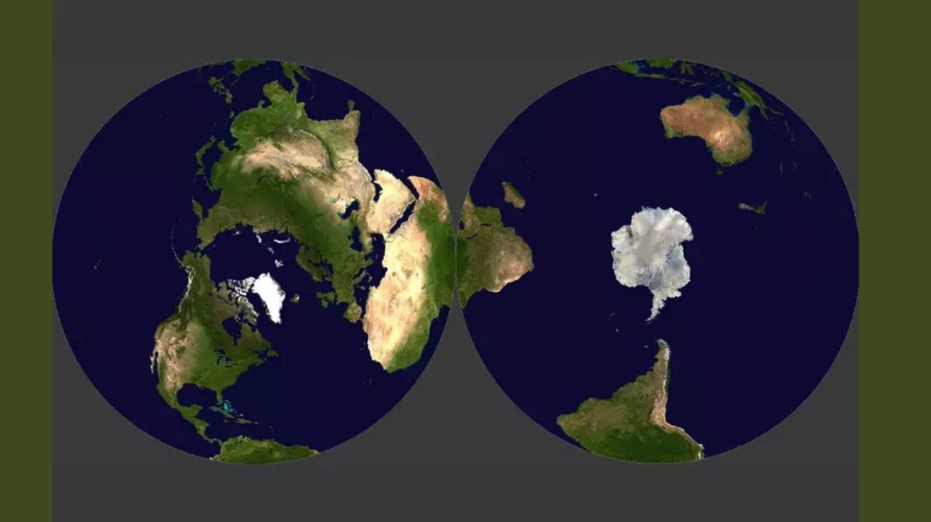
New Cartographic Projection Presents Unique Representation of Northern and Southern Hemispheres on Opposite Sides of a Disk, Surpassing Historical Distortions and Preserving the Continuity of Continents Without Conventional Cuts
The Earth map that is the most accurate ever created was developed by physicists at Princeton University in the United States and features an innovative disk-shaped format. Each face represents a hemisphere, north or south, and the result minimizes the common distortions found in traditional cartographic projections, offering greater fidelity to the planet’s spherical surface.
According to the authors, this approach surpasses widely used projections such as Mercator and Winkel-Tripel, especially in terms of continuity, as it avoids cuts in the Pacific Ocean, which are common in conventional maps. “You can’t do everything perfectly. A map is as good at one thing as it is not at representing others,” stated physicist Richard Gott.
The solution was presented as an alternative for representing the Earth’s surface in a plane without losing the real proportions of areas and shapes. The project is based on rigorous metrics to assess deformations, including areas, distances, curvature, asymmetry, and cuts.
-
Motorola launched the Signature with a gold seal from DxOMark, tying with the iPhone 17 Pro in camera performance, Snapdragon 8 Gen 5 that surpassed 3 million in benchmarks, and a zoom that impresses even at night.

-
Satellites reveal beneath the Sahara a giant river buried for thousands of kilometers: study shows that the largest hot desert on the planet was once traversed by a river system comparable to the largest on Earth.

-
Scientists have captured something never seen in space: newly born stars are creating gigantic rings of light a thousand times larger than the distance between the Earth and the Sun, and this changes everything we knew about stellar birth.

-
Geologists find traces of a continent that disappeared 155 million years ago after separating from Australia and reveal that it did not sink, but broke into fragments scattered across Southeast Asia.

Cartographic Problem That Persists for Centuries
Humanity has known that the Earth is spherical for millennia, but this characteristic has not always posed a practical challenge. For centuries, maps showed only limited regions of Eurasia and Africa, without including the Americas, Oceania, and Antarctica. Under these conditions, the distortions were not relevant for navigation or everyday use.
With the advancement of maritime exploration and aviation, cartographic precision became essential. The Mercator projection, created in the 16th century, began to be widely used by navigators as it preserved shapes and directions but distorted the size of areas near the poles.
In the 20th century, alternatives like the Winkel-Tripel projection emerged, adopted by the National Geographic Society, which reduced distortions but still had limitations near the edges of the globe.
New Model Surpasses Traditional Projections
In 2007, David Goldberg and Richard Gott developed a scoring system to evaluate maps based on six technical criteria. On this scale, a perfect globe would score 0, and the higher the value, the greater the distortion. The Winkel-Tripel projection scored 4.563 points, while the new Earth map received 4.497 points, being considered the most accurate ever designed.
The highlight is in how the projection preserves geographical continuity. Instead of presenting vertical cuts that separate continents, the new map distributes the hemispheres across two faces of the same disk, maintaining visual integrity and reducing area distortions.
Additionally, the new approach allows for different astronomical elements to be mapped in the same format, including planets, the celestial dome, and the Cosmic Microwave Background.
Technique and Design of the Disk Map
The concept of a double-sided disk was inspired by the idea of representing the planet as if it were a “vinyl,” where side A shows the northern hemisphere and side B displays the southern hemisphere. This configuration can be printed front and back, facilitating physical handling and consultation.
The cut used in the map is positioned along the equator, but the authors state that it could also be at the Greenwich meridian. The choice of cut is strategic, as it directly influences the minimization of deformations and the perception of continuity.
The proposal also seeks to expand the application of this type of projection in areas such as education, research, and design, making geography visually more accurate for the public.
Impact and Future Applications
The development of this Earth map could impact everything from the production of educational materials to scientific projects that depend on high cartographic precision. In areas such as climatology, oceanography, and geopolitics, a model with fewer distortions can provide more accurate interpretations of global data.
The projection could also be adapted for use in digital environments, allowing interactive maps to preserve scales and distances more accurately than current rectangular projections.
Researchers point out that while widespread adoption depends on technological adaptation, the model represents a milestone for contemporary cartography.


-

Uma pessoa reagiu a isso.