 English
  Francês
  Alemão
  Italiano
  Japonês
  Norueguês
  Portuguese
  Spanish
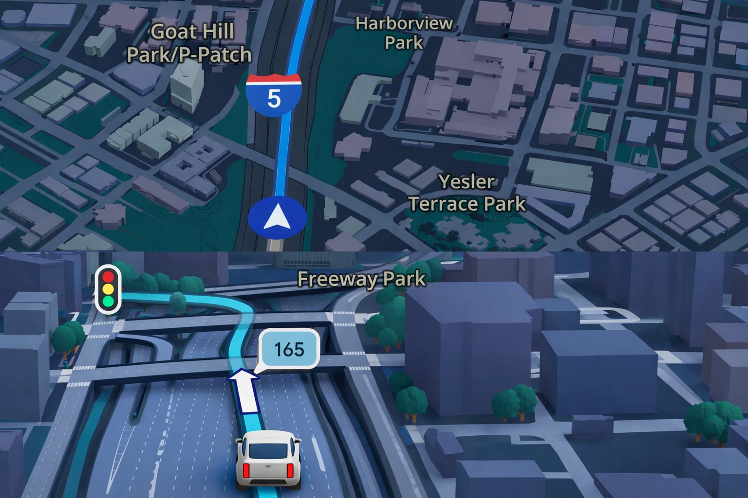
New Google Maps Update Incorporates Artificial Intelligence to Answer Complex Questions About Routes, Suggest Stops, and Improve Navigation with 3D Images and Street View Data.
Initially, Google announced on Thursday, December 12, a series of updates to Google Maps, the widely used GPS navigation application.
Furthermore, according to an official statement from Google, the updates introduce artificial intelligence systems that enhance route and travel planning capabilities within the platform.
Thus, the main innovation involves a feature called Ask Maps, a tool based on artificial intelligence.
-
Casio Unveils Moflin, Robotic Pet With Artificial Intelligence Designed To Provide Emotional Comfort And Simulate A Permanent Affectionate Bond

-
China Warns the U.S. of a “Terminator” Style Apocalypse: Military AI Rivalry, Sanctions Against American Startup, and Fear of Algorithms Deciding Who Lives or Dies Place the World on the Brink of a Nightmare That Seemed Like Fiction

-
Many Use It Every Day, but Few Know That ChatGPT Has Limitations in Brazil: Users Under 14 Need Authorization, Sensitive Data Should Not Be Entered, and Content May Be Monitored in Specific Cases

-
UTCAL Summit 2026 in Rio Discusses Cybersecurity with AI to Protect Critical Infrastructures and Cyber-Physical Systems


Consequently, this functionality is designed to answer complex questions from users, assisting in the selection of routes, stops, and activities along the way.
Ask Maps Feature Answers Complex Questions About Routes
First of all, Ask Maps allows users to ask questions directly to the application, using natural language.
For example, according to Google itself, the system will be able to answer questions such as:
- “I am going to the Grand Canyon. Are there good stops along the way?”
- “Is it worth taking a detour on this route?”
Additionally, the system explains the advantages and disadvantages of alternative routes, enabling drivers to make informed decisions during their journey.
Thus, the feature uses the most recent information available in the Google Maps database.
Consequently, the platform can provide detailed recommendations about locations and routes.
System Uses Updated Data and Recommends Experiences
Moreover, Ask Maps combines different information from the application to guide users during navigation.
Among the available possibilities, the system can provide:
- estimated arrival time
- tips from people who know the area
- recommendations for hidden trails
- information on how to obtain free tickets
Therefore, the feature transforms Google Maps into a more comprehensive tool for planning outings and trips.
Additionally, the system will also allow users to make restaurant reservations directly through the app.
Similarly, users will be able to share locations and recommendations with friends within the platform.
Update Brings More Detailed 3D Visualization of the Environment
At the same time, Google also announced significant visual changes in the mobile application.
Now, map images will have a three-dimensional (3D) view.
Thus, users will be able to observe in more detail:
- buildings
- overpasses
- the terrain elevation around the vehicle
Consequently, navigation becomes more realistic and intuitive during movement.
Integration with Gemini Expands Navigation Features
Furthermore, Google Maps will now integrate the Gemini system, an artificial intelligence language developed by the company itself.
Therefore, the application will be able to provide more detailed instructions about traffic and the urban environment.
Among the additional information offered by the platform, the following stand out:
- traffic lanes
- crosswalks
- traffic lights
- stop signs
To enable this functionality, the system uses images from Street View.
This feature, in turn, offers 360-degree panoramic views at street level.
Furthermore, aerial images are also used to complement urban environment data.
Application Explains Advantages and Disadvantages of Route Diversions
Moreover, when Google Maps suggests a detour, the application will clearly explain the pros and cons of this route change.
Thus, the user will be able to evaluate the alternatives before choosing the most suitable path.
Consequently, the final decision is still made by the driver.
Launch Begins in the United States and Will Be Expanded
Finally, according to the statement from Google released on December 12, the updates will initially be made available in the United States.
Subsequently, the company reported that the expansion will occur in the coming months.
Thus, the features are expected to gradually reach compatible devices, including:
- iOS smartphones
- Android smartphones
- Apple CarPlay
- Android Auto
- vehicles with integrated Google systems
However, the company has not yet announced the release date of the technology in Brazil.


-

2 pessoas reagiram a isso.