 Portuguese
  English
  Spanish
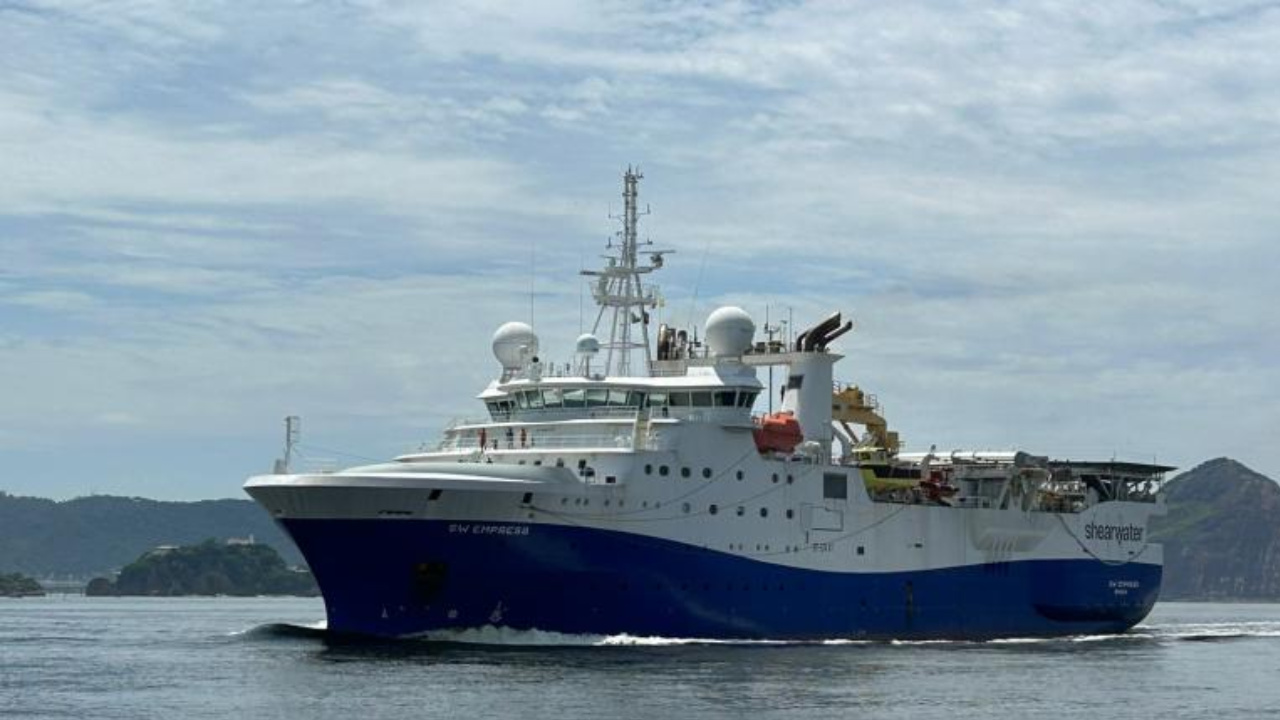
Vessel Returns to Rio Grande and Resumes Advanced Studies to Assess Oil Potential in the Pelotas Basin.
The search for oil in the Pelotas Basin is back in the spotlight with the return of the largest seismic research vessel in the world to the municipality of Rio Grande, in the southern coast of Rio Grande do Sul. The vessel SW Empress, operated by the Norwegian company Shearwater, has once again begun using the local port infrastructure as a logistical base for offshore work.
With approximately 80 professionals on board, including researchers, specialized technicians, and operational crew, the ship marks a new phase of studies aimed at the detailed mapping of the seabed. The resumption of activities took place last week and, according to the current schedule, is expected to extend until the second half of 2026.
Rio Grande Serves as a Strategic Base for Seismic Work
In addition to receiving the large vessel, the Port of Rio Grande plays a crucial role in supporting operations. Smaller vessels use the location for refueling, crew change, and general logistics. According to NavOcean, an environmental consulting firm contracted by Shearwater, an auxiliary vessel docks at the port every 15 days.
-
Petrobras evaluates suspension of sales to distributors and considers canceling the cooking gas auction following guidelines from the Federal Government.
-
Lula reveals a masterstroke by Petrobras to undo a deal made by Bolsonaro, which involves the return of an important refinery that currently produces less than half of what was expected and makes Brazil dependent on international diesel.

-
A study confirms that the natural gas sector will reduce greenhouse gas emissions in Brazil by 0.5% and accelerate the energy transition by 2026.

-
Petrobras implements a severe adjustment and confirms a 55% increase in the price of aviation kerosene with a proposal for installment payments for the companies.


During these periodic stops, in addition to fuel and supply delivery, seismic data collected at sea is transported. The information, stored on hard drives, is sent to the processing centers of the Norwegian company, where it undergoes thorough technical analysis before being sold.
The data is then sold to Petrobras, the winner of the exploratory blocks in the region.
The ongoing seismic research is of the 3D type and covers an area of approximately 17,300 square kilometers. The work is concentrated about 156 kilometers from the coast, in a strip near the municipality of Santa Vitória do Palmar.
The SW Empress impresses with its dimensions. It is 122 meters long, equivalent to the size of a city block, and 22 meters wide at its widest point. The vessel arrived in Rio Grande last weekend, resuming an operation that had previously been conducted the year before and ended in June.
Although the amount invested in this phase has not been disclosed, in 2024, Shearwater allocated around R$ 400 million to seismic studies in the region.
How Seismic Surveys for Oil Work
In the Pelotas Basin, there is still no commercial confirmation of oil existence. Therefore, seismic surveys are considered essential. The technique works like a kind of ultrasound of the seabed.
During the operation, special equipment emits sound waves that penetrate the seabed. Upon encountering different geological layers, these waves are reflected and return to the sensors attached to the vessel. The time and intensity of the return allow mapping of the geological structure and identifying possible accumulations of hydrocarbons, such as oil and natural gas.
According to NavOcean, no impacts on artisanal fishing have been recorded. “This research is conducted in very deep waters, and no occurrences of impacts on artisanal fishing have been reported,” the company informed. Nonetheless, the results obtained in 2024 have not been disclosed.
Geological Indications Reinforce Scientific and Economic Interest
According to Professor Giovani Cioccari from the Federal University of Pelotas (UFPel), previous studies indicate promising, although still inconclusive, signs. Analyses of intervals of previously drilled wells have pointed to indications of hydrocarbons in the region.
— This region has a more structured geological configuration compared to the rest of the basin, with greater potential for hydrocarbon reservoirs. However, only seismic studies will indicate the real potential of the area, and in case of a positive outcome, only well drilling will confirm existence — explains the geologist.
This context keeps the Pelotas Basin on the radar of major companies in the oil sector.
In addition to Shearwater, other companies are also active in the region. The company TGS began activities last Saturday (29), but off the coast of Santa Catarina. In total, four companies are licensed to conduct seismic surveys along the coast of Rio Grande do Sul.
Among them are, besides Shearwater, Viridien and SLB WesternGeco. The movement reinforces the continuous interest of the oil industry in the exploratory potential of Brazil’s southern margin.
Ibama Conducts Rigorous Environmental Licensing Process
To operate in the search for oil, companies need authorization from the Brazilian Institute of Environment and Renewable Natural Resources (Ibama). The process begins with the classification of the proposed activity.
At this stage, the agency assesses two main criteria: the depth of the research area and the environmental sensitivity of the region. From this, the type of required environmental study is defined.
In the Pelotas Basin, technicians analyze factors such as possible impacts on the fishing fleet that uses hooks near the surface, especially for tuna catch, in addition to the risk of collisions between large oceanic birds and the cables of seismic vessels.
History Shows Successive Cycles of Oil Search
The history of oil exploration in the Pelotas Basin dates back to the 1950s. Since then, four main cycles of research have been recorded, all marked by technological advancements and still inconclusive results.
The first cycle occurred between the 1950s and 1960s when Petrobras drilled eight onshore wells based on gravimetric surveys. None of them showed significant presence of hydrocarbons.
In the 1970s, the first seismic studies on the continental shelf led to the drilling of seven wells in shallow waters, also without success.
In the 1990s, new seismic acquisitions led to the drilling of four wells between 1995 and 1996, again without positive results.
The most recent cycle began in 1997, with the creation of the National Agency of Oil, Natural Gas, and Biofuels (ANP). Since then, the auctions for exploratory areas and the advancement of environmental licensing have enabled the resumption of seismic surveys, which continue to this day in the region.


Seja o primeiro a reagir!