 Portuguese
  English
  Spanish
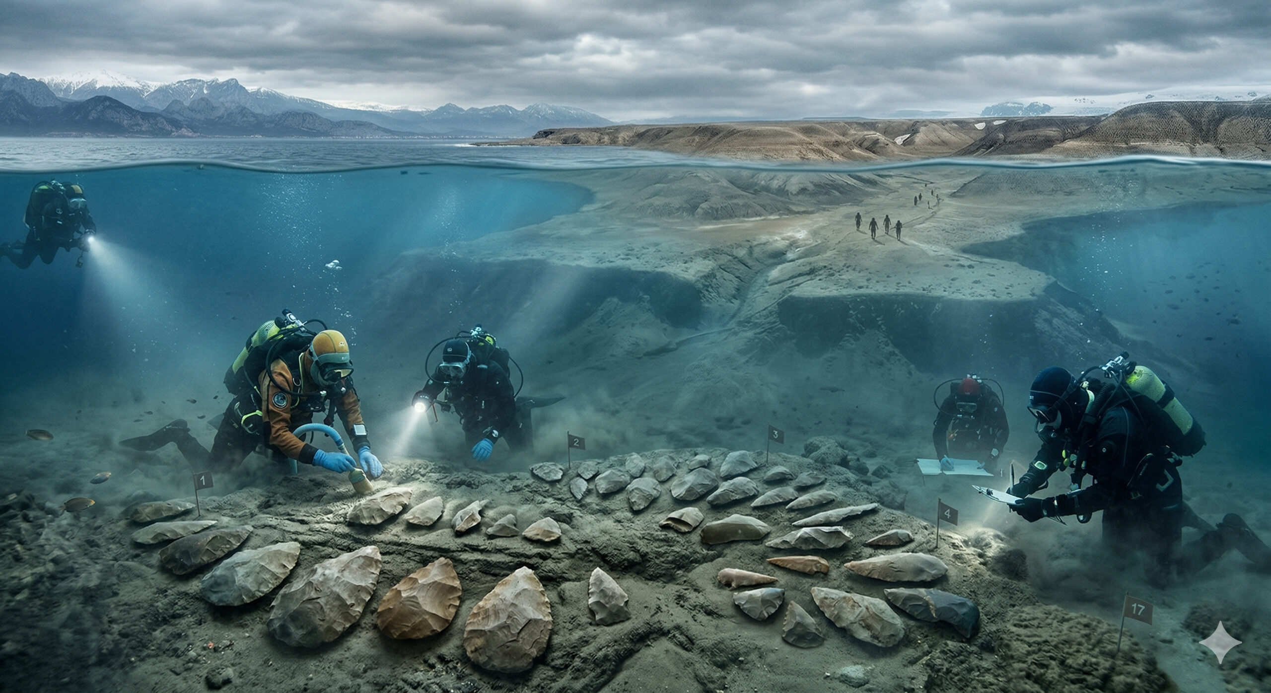
138 Paleolithic tools found under the sea in Turkey indicate a possible land bridge used by humans during the Ice Age to migrate to Europe
In 2025, an international team of archaeologists announced the discovery of 138 Paleolithic stone tools in the coastal region of Ayvalık, in western Turkey, in an area associated with ancient landscapes now partially submerged in the Aegean Sea. According to a study published in the Journal of Island and Coastal Archaeology, the research identified the artifacts at 10 sites and concluded that Ayvalık was exposed as dry land at different times during the Pleistocene, when the fall in sea level created opportunities for human occupation and mobility between areas that are now separated by water.
The main implication of the discovery is the possibility that this area functioned as a natural land bridge, connecting regions now separated by the sea and allowing the migration of prehistoric human groups between Anatolia and parts of southeast Europe. The study’s own abstract states that Ayvalık may have served as a strategic point for human dispersal in the northeastern Aegean, while the scientific repercussions highlighted that this alternative route challenges more traditional models focused solely on the Balkans and the Levant.
Stone tools indicate human presence in an area now submerged
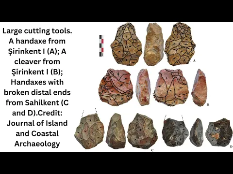
The tools found are classified as lithic artifacts, produced by stone flaking, a technique characteristic of Paleolithic human groups. Among the identified objects are:
-
Argentina places the first U.S. Stryker 8×8 armored vehicles in operational units, while Brazil sets a record of $3.1 billion in military exports, reaching 140 countries and strengthening the Defense Industrial Base.
-
A flight attendant fell from 10,160 meters without a parachute after an airplane explosion, survived against all logic, and still holds the record for the highest fall ever survived by a human being.

-
With a monumental stone structure dating back over 2,000 years, excavated 6 meters deep and with dimensions that surprise archaeologists, the newly discovered tank in Gabii may be one of the first major public works of Ancient Rome outside of temples and walls.
-
Goodbye fitness bracelet: users around the world are replacing the old item with this more discreet, comfortable smart ring that can monitor health for several days without recharging.


- blades and scrapers
- fragments of stone cores
- pieces associated with tool production
These artifacts were located in 10 distinct archaeological sites, distributed along the current coastline. The concentration of tools at different points reinforces the hypothesis of continuous human occupation in the region.

The fact that these areas are now partially submerged indicates that, in the past, the sea level was significantly lower, exposing territories that are now underwater.
During the Ice Age, the sea level was up to 120 meters lower
Widely accepted geological data indicate that during the last glacial period, the global sea level was up to 120 meters lower than it is today. This phenomenon occurred due to the large volume of water retained in continental glaciers.
As a result, extensive coastal areas were exposed, creating land corridors that no longer exist. These formations allowed humans and animals to move between regions that are currently separated by oceans or seas.
In the case of the Aegean Sea, the reduction in sea level may have revealed a landscape composed of plains, valleys, and possible migration routes.
Strategic location reinforces the hypothesis of a human migration route
The Ayvalık region occupies a strategic geographical position between Anatolia (present-day Turkey) and southeastern Europe. This location makes the site a possible crossing point for human groups migrating towards the European continent.

The presence of Paleolithic tools in this area suggests that humans not only passed through the region but possibly used it repeatedly.
This hypothesis aligns with theories already discussed in archaeology about multiple human migration routes, beyond the well-known pathways through the Middle East and northern Africa.
Discovery broadens understanding of prehistoric migrations
Traditionally, models of human migration to Europe focus on well-established land routes, such as the Levant corridor. However, the discovery in the Aegean Sea suggests that other routes may have been used.
The existence of a possible land bridge between regions now separated expands the scenario of human mobility in the Paleolithic, indicating that movements may have been more diverse and complex than previously thought.
Furthermore, the discovery reinforces the importance of submerged coastal areas as key locations for future archaeological research.
Technology and methods allowed the identification of submerged sites
The identification of the tools involved a combination of traditional archaeological methods and modern mapping techniques. The researchers used geological analyses, coastal surveys, and sediment distribution studies to locate the sites.
Although some of the artifacts are in areas now accessible on dry land, others were found in zones close to the waterline or in regions that have undergone changes over the millennia.
This type of approach is becoming increasingly common in archaeology, especially in studies focused on ancient landscapes that have been transformed by climate changes.
Tools help reconstruct the behavior and technology of human groups
The analysis of the found tools allows for understanding important aspects of the human groups that occupied the region. The type of flaking, the shape of the pieces, and the material used provide clues about:
- technical skills
- survival strategies
- use of natural resources
These elements help reconstruct the way of life of these groups, including activities such as hunting, food processing, and adaptation to the environment.
Discovery reinforces the importance of submerged areas in global archaeology
In recent years, underwater archaeology has gained relevance due to the recognition that many areas occupied by humans in the past are now submerged.
Changes in sea level over thousands of years have completely transformed the terrestrial map, hiding possible archaeological sites underwater.
The discovery in the Aegean Sea adds to other similar finds around the world, indicating that a significant part of human history may be hidden in submerged environments.
The hypothesis of the land bridge is still under scientific analysis
Although the presence of the tools is a concrete fact, the interpretation that there was a continuous land bridge is still under analysis. Researchers are working with geological models and archaeological data to reconstruct the ancient landscape.
This stage involves:
- sediment analysis
- sea level modeling
- comparison with other sites in the region
Only with the combination of these data will it be possible to confirm with greater precision the extent and function of this possible land route.
Discovery opens new research possibilities in the Mediterranean
The Mediterranean region, including the Aegean Sea, is considered one of the most important areas for the study of human evolution.
The discovery of Paleolithic tools in Ayvalık expands the research potential in the region, especially in areas that have not yet been systematically explored. With the advancement of detection and mapping technologies, new discoveries may arise in regions that were previously considered less promising for archaeology.
Do you believe that entire routes of human migration may still be hidden under the sea?
The discovery of tools in an area now submerged raises the possibility that complete routes of human movement are concealed beneath the waters, awaiting more in-depth scientific investigation.
With past climate changes drastically altering sea levels, part of human history may be out of the direct reach of traditional excavations.
In your opinion, how many other prehistoric routes may still be hidden beneath the ocean? Share your thoughts in the comments.


Seja o primeiro a reagir!