 Portuguese
  English
  Spanish
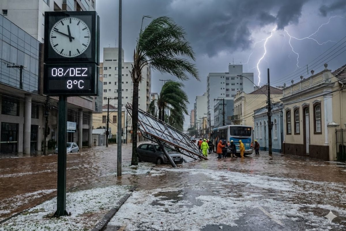
Formation of the New Extratropical Cyclone Between December 8 and 9 Should Bring Severe Weather, Winds of Up to 120 km/h, Lightning, Hail, Rough Seas, Flooding, and Power Outages for Millions of People in the South, With Reflections in São Paulo, Rio, Minas, and Mato Grosso do Sul Until the 11th.
A new extratropical cyclone forming between December 8 and 9 is expected to sharply change the weather pattern in the South, Southeast, and parts of the Midwest, putting millions of people on alert for severe weather, very strong winds, rough seas, and a significant drop in temperature between December 8 and 11.
Described by meteorologists as a system of strong intensity, the extratropical cyclone is expected to operate with atmospheric pressure below 1,000 hPa, a condition that usually enhances severe storms, wind gusts above 100 km/h, and episodes of intense rain over a short period, with the risk of flooding, power outages, and damage to urban and rural structures.
Formation and Trajectory of the System
The new extratropical cyclone is born from the intensification of a low-pressure area between southern Paraguay, northeastern Argentina, and Rio Grande do Sul throughout the afternoon and evening of Monday, December 8.
-
Researchers from Embrapa have discovered how to transform the saline water found in 140,000 wells in the Brazilian Semi-Arid region into a tool for producing food in an area where agriculture has always relied solely on rainfall.

-
China inaugurates a ghost factory that operates in the dark 24 hours a day without any human workers and produces 10 million smartphones a year using 97% of equipment developed by the company itself.

-
Scientists create a semiconductor that mimics the human brain using hydrogen and boost a new generation of smart chips with learning capabilities and the potential to revolutionize artificial intelligence applications.

-
Scientists discover that humanity has exchanged one environmental disaster for another: the same chemicals that saved the ozone layer are now contaminating rivers, aquifers, and human blood with an eternal pollutant that is impossible to remove.


During this period, the temperature contrast and strong divergence at altitude favor the rapid organization of the system.
In the early hours of Tuesday, December 9, the low-pressure center deepens, the cyclone organizes completely, and crosses the gaucho territory from west to east, reaching the Porto Alegre region by night.
From then on, the cyclonic circulation begins to channel warm, humid air from the Amazon region and the interior of the continent, feeding vertically developed clouds.
Between the early hours and the morning of Wednesday, December 10, the center of the system should reach the sea near the coast of Rio Grande do Sul.
From that moment on, the new extratropical cyclone gradually moves offshore while maintaining a strong pressure gradient and, consequently, intense winds along the southern coast of Brazil.
Extreme Winds, Intense Rain, and Rough Seas
With very low atmospheric pressure, the circulation associated with the system favors the formation of cumulonimbus clouds, responsible for severe storms, frequent lightning, hail, and wind microbursts.
In such episodes, the occurrence of destructive gusts associated with tornadoes in localized areas cannot be ruled out.
Models indicate that on Wednesday, December 10, with the new extratropical cyclone fully structured and positioned near the gaucho coast, gusts of 90 km/h to 120 km/h may hit areas of Rio Grande do Sul and Santa Catarina, especially in mountainous and coastal regions.
These speeds are sufficient to strip roofs, topple trees, poles, and cause interruptions to power supply.
In addition to the wind, the combination of warm air, high humidity, and cold front associated with the system is expected to cause heavy rain over a short period, increasing the risk of flooding, flash floods, and landslides on slopes.
Along the coast, the sea is likely to become very agitated, with high waves and strong surf, especially along the coasts of Rio Grande do Sul and Santa Catarina.
South Will Face the Most Severe Impacts
The South of the country will be the most affected region by the new extratropical cyclone.
In Rio Grande do Sul, forecasts indicate severe weather starting early Tuesday, with heavy rain and lightning, mainly in Greater Porto Alegre and areas of Campanha and Serra.
Wednesday is likely to be the most critical day for strong winds, with intense gusts widely across the state.
In Santa Catarina, instability should intensify between December 9 and 10, with high risk of heavy rain and very strong winds, especially on the coast, in the Itajaí Valley, and in the Plateau.
The conditions favor flash floods, urban flooding, and road problems, along with the possibility of localized hail.
In Paraná, Tuesday will be marked by unstable weather, with rain and lightning in several regions.
Beginning Wednesday, wind gusts are expected to become more frequent, particularly in the south and east of the state, including areas near Serra do Mar, where the terrain may amplify the effects of the wind.
Reflections in the Southeast and Midwest
Although the center of the new extratropical cyclone remains over the South and moves towards the ocean near the gaucho coast, its effects reach the Southeast.
In São Paulo, the expectation is for increased winds starting Tuesday, with more intense gusts on Wednesday, especially along the coast, in Greater São Paulo, and in Serra do Mar, where the combination of terrain and cold front may generate isolated severe weather.
In Rio de Janeiro, the outlook indicates strong winds in the central-southern fluminense region, including the Metropolitan Region, the Baixada Fluminense, and part of the Serra.
The instability is expected to result in rain showers, lightning, and possible rough seas in coastal stretches, requiring attention from residents in coastal and hillside areas.
In Minas Gerais, the effects are concentrated in the South of Minas, in the Zona da Mata, in the Triângulo Mineiro, and in Greater Belo Horizonte.
In these areas, the presence of the cold front associated with the new extratropical cyclone may cause increased cloudiness, localized rain, and a moderate drop in temperature.
The overall risk is lower than in the South, but isolated severe weather cannot be ruled out.
In the Midwest, Mato Grosso do Sul will be the most impacted state.
Forecasts indicate moderate gusts as early as Monday, with the potential for strong winds on Tuesday, as well as rain and lightning in various areas.
Mato Grosso and Goiás may also experience increased instability, but with lower intensity, maintaining the typical heat and rain of summer, albeit influenced by the cyclone’s circulation.
Dissipation of the System and Change in the Weather Pattern
The expectation is that the center of the new extratropical cyclone will reach the sea off the coast of Rio Grande do Sul between the early hours and the morning of Wednesday, December 10.
From then on, the system should move offshore throughout Thursday, December 11, gradually distancing itself from Brazil, but still influencing the wind field and the sea state in the South region.
Even as it dissipates, the system will continue to fuel strong winds and rough seas along the coast of Rio Grande do Sul and Santa Catarina, with the possibility of strong surf and navigation restrictions in stretches of the coast.
In the interior of the continent, the advance of the cold air mass associated with the cyclone is expected to lower temperatures, making the cold feel more pronounced for this time of year.
In the following days, the weather should gradually stabilize in the South starting Thursday, with decreased rain and less severe instability, although isolated showers may still occur.
In the Southeast, the trend is for the maintenance of localized instability and milder temperatures, while in the Midwest, the heat returns to gain strength, but with typical seasonal rain showers.
Safety Recommendations and Ongoing Monitoring
Given the presence of the new extratropical cyclone and the forecast of intense winds, rough seas, and severe storms, the guidance from Civil Defense and specialists is to avoid coastal areas and open sea during the peak of the system, when navigation conditions become dangerous and increase risks to small and medium vessels.
During storms, the public should avoid seeking shelter under trees and stay away from power lines, poles, or exposed metal structures.
It is recommended to reinforce roofs, check gutters, trim branches that may hit power lines, and remove loose objects from balconies, backyards, and roofs that could be easily thrown by gusts above 90 km/h.
Residents in areas prone to flooding, flash floods, or landslides should closely monitor warnings from Civil Defense and meteorological services, which may issue emergency alerts and, in extreme cases, indicate preventive evacuation in neighborhoods or slopes at higher risk.
December often registers the formation of severe systems, but the intensity forecast in this episode reinforces the need for constant monitoring and well-defined contingency plans by municipalities.
In light of this scenario, have you noticed changes in the weather in your city or taken any measures to prepare for the passing of the new extratropical cyclone?


-

Uma pessoa reagiu a isso.