 Portuguese
  English
  Spanish
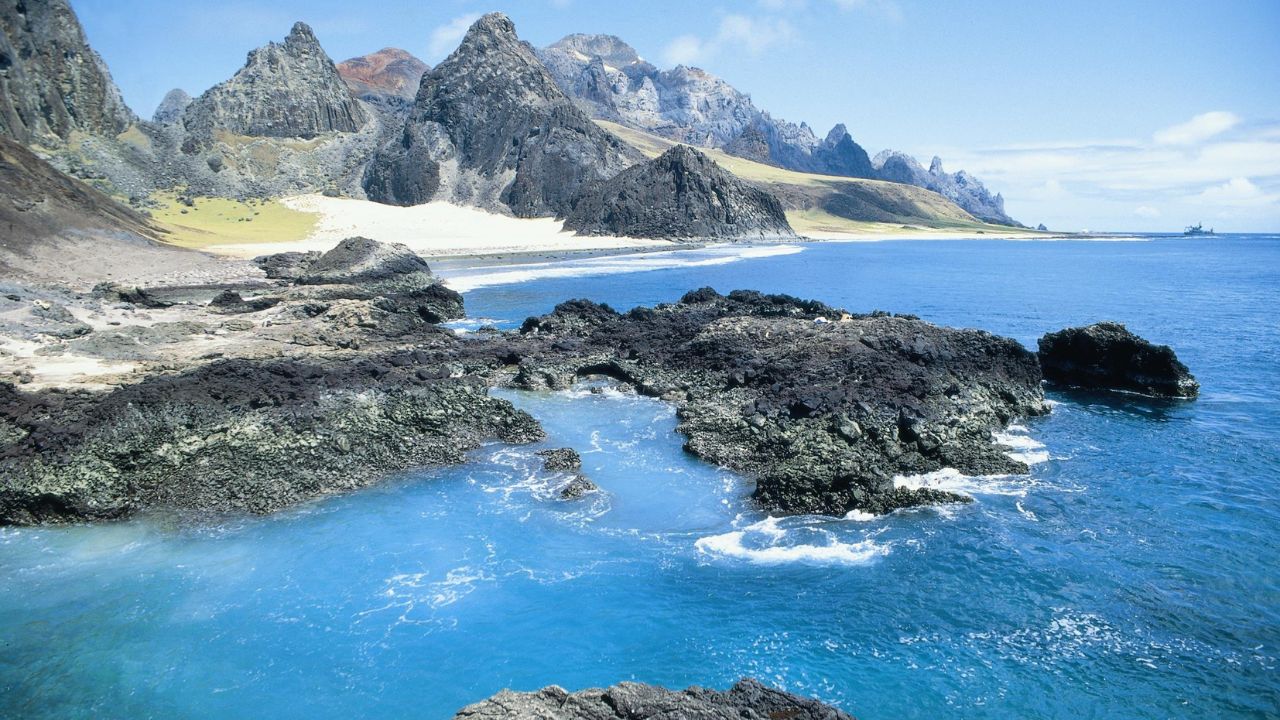


1,200 km From the Coast, Volcanic Territory Houses the Youngest Rocks in the Country and Functions as a Geopolitical and Scientific Pillar for National Sovereignty.
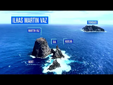
Popular imagination and many textbooks teach that the sun rises first at Ponta do Seixas, in Paraíba. However, official geography reveals a surprising truth: the true easternmost point of Brazil is a remote archipelago of volcanic islands with restricted access, located more than one thousand kilometers from the mainland. The Trindade and Martim Vaz Archipelago, an inhospitable territory of wild beauty, redefines the country’s borders, projecting Brazilian sovereignty over a vast and strategic area of the South Atlantic.
This outpost is not just a geographical landmark. Its importance is multifaceted, functioning as a pillar for national defense, a natural laboratory of invaluable worth for science, and a sanctuary for unique species on the planet. The constant presence of the Brazilian Navy since 1957 ensures not only possession of the territory but also enables a robust research agenda that ranges from the geology of its young rocks to the conservation of fragile ecosystems, as detailed by the Brazilian Navy Agency of News.
The Geopolitical Frontier in the Middle of the Atlantic
The designation of Martim Vaz as the easternmost point of Brazil is far from a mere cartographic detail; it has profound geopolitical implications. According to the UN Convention on the Law of the Sea, cited in documents from the Brazilian Navy, possession of insular territories allows a country to extend its Exclusive Economic Zone (EEZ) by 200 nautical miles (about 370 km) around it. In practice, sovereignty over this small archipelago of only 10.4 km² guarantees Brazil exclusive rights over an ocean area of approximately 450,000 km².
-
Friends have been building a small “town” for 30 years to grow old together, with compact houses, a common area, nature surrounding it, and a collective life project designed for friendship, coexistence, and simplicity.

-
This small town in Germany created its own currency 24 years ago, today it circulates millions per year, is accepted in over 300 stores, and the German government allowed all of this to happen under one condition.

-
Curitiba is shrinking and is expected to lose 97,000 residents by 2050, while inland cities in Paraná such as Sarandi, Araucária, and Toledo are experiencing accelerated growth that is changing the entire state’s map.

-
Tourists were poisoned on Everest in a million-dollar fraud scheme involving helicopters that diverted over $19 million and shocked international authorities.

This immense area, part of the so-called “Blue Amazon”, is vital for the economy and national security. It is the route for over 95% of Brazilian foreign trade and where the majority of the country’s oil is extracted, reinforcing the Brazilian Navy’s analysis of the region’s strategic importance. The presence in Trindade and Martim Vaz, therefore, transforms a geographical coordinate into a powerful instrument of sovereignty, ensuring control over fishing, mineral resources, and essential navigation routes.
A Natural Laboratory: Living Geology and Unique Biodiversity
The archipelago is the visible tip of a colossal underwater mountain chain of volcanic origin, the Vitória-Trindade Chain. Formed by the passage of the South American tectonic plate over a “hotspot” in the Earth’s mantle, the territory houses the youngest rocks in Brazil, with volcanic activity recorded about 50,000 years ago, an event considered extremely recent in geological time. This geological “youth” provides scientists with a dynamic study field to understand the formation of oceanic islands and the colonization of life in sterile environments.
This millennia-long isolation has given rise to a unique ecosystem, classified by the CCMA Management Network as a biodiversity hotspot. The region harbors the greatest diversity of calcareous algae in the world and an immense wealth of fish. On land, there are giant fern forests that can exceed six meters in height and endemic species such as the Trindade petrel and the ubiquitous yellow crab. Trindade Island is also home to the largest nesting site of the green turtle (Chelonia mydas) in Brazil, a phenomenon closely monitored by the TAMAR Project with support from the Navy, as reported by the Brazilian Navy Agency of News.
Sovereignty and Science: The Mission of the Navy in the Archipelago
Access to the archipelago is strictly controlled, restricted to authorized military personnel and scientists. The heart of this operation is the Oceanographic Station of Trindade Island (POIT), maintained by the Navy since 1957. The mission of POIT is complex: to ensure sovereignty, conduct strategic surveillance of maritime and air traffic, collect meteorological data, and crucially, serve as a logistical support base for the scientific community. Without this structure, research in such a remote location would be logistically unfeasible.
This synergy between defense and science is the cornerstone of the Scientific Research Program at Trindade Island (PROTRINDADE). Thanks to the Navy’s support, researchers from all over Brazil can study in loco everything from volcanic rocks and reef fish to endemic flora, as mentioned by the Brazilian Navy Agency of News. Science legitimizes and enriches military presence, while military presence enables science. It is a model of integrated management that strengthens Brazil’s position as a responsible actor committed to advancing knowledge and conservation.
Environmental Challenges: From Invasive Species to Plastic Rocks
Despite its isolation, Trindade is not immune to human threats. The introduction of goats and pigs from the 18th century devastated native vegetation, causing severe erosion and the extinction of entire forests. In response, the RETER-Trindade project works on ecosystem recovery by eradicating invasive species and reintroducing native plants, an initiative highlighted by the Brazilian Navy Agency of News.
More alarmingly, the archipelago has become the stage for a phenomenon that symbolizes the era of the Anthropocene: the formation of “plastic rocks”. Researchers have discovered that plastic debris, mainly fishing nets, melt under heat and fuse with beach sediments, creating a new type of artificial rock. The existence of plastiglomerates in the territory with the youngest natural rocks in Brazil is a shocking paradox and a warning that there is no longer a place on the planet free from the impact of human pollution.
The history of the Trindade and Martim Vaz Archipelago reveals the complex relationship between sovereignty, science, and the environment. This remote territory is both a sentinel of our maritime sovereignty and a mirror of our global environmental responsibilities.
In your opinion, what is the greatest importance of this archipelago for Brazil’s future: the strategic and geopolitical or the scientific and environmental? Share your point of view in the comments, we want to know how you see the value of this Brazilian heritage.


Faltou comentar que esse lugar está situado nas águas do Estado do Espírito Santo, mais especificamente no litoral da Capital, VITÓRIA.