 Portuguese
  English
  Spanish
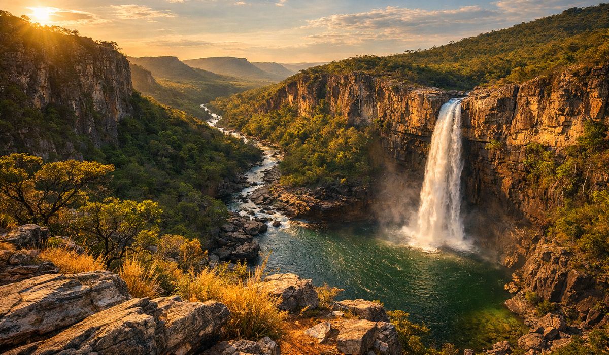
Between Canyons, Rivers and Traditional Communities, Chapada dos Veadeiros Brings Together Very Old Rocks, Dozens of Trails and Waterfalls in a Mosaic of National Park and Surrounding Areas, with International Recognition and Community Tourism in the Kalunga Territory.
Chapada dos Veadeiros, in northeastern Goiás, concentrates geological formations over 1 billion years old and hundreds of waterfalls in an area of Cerrado that integrates the site recognized by UNESCO as a Natural Heritage of Humanity since 2001.
The landscape of canyons, fields, and rivers runs parallel to a history marked by the gold cycle, successive changes in the boundaries of the national park, and the presence of the Kalunga Quilombola Territory, where tourism follows rules set by the communities.
Fazenda Veadeiros, Gold Cycle and Origin of the National Park
The occupation of the region gained momentum around 1750, when the old Fazenda Veadeiros brought together farmers attracted by gold and cattle ranching, according to historical records about the area.
-
Friends have been building a small “town” for 30 years to grow old together, with compact houses, a common area, nature surrounding it, and a collective life project designed for friendship, coexistence, and simplicity.

-
This small town in Germany created its own currency 24 years ago, today it circulates millions per year, is accepted in over 300 stores, and the German government allowed all of this to happen under one condition.

-
Curitiba is shrinking and is expected to lose 97,000 residents by 2050, while inland cities in Paraná such as Sarandi, Araucária, and Toledo are experiencing accelerated growth that is changing the entire state’s map.

-
Tourists were poisoned on Everest in a million-dollar fraud scheme involving helicopters that diverted over $19 million and shocked international authorities.


At the turn of the following century, in 1892, Chapada entered the route of the Central Plateau Exploratory Commission, headed by astronomer Luís Cruls.
The mission traversed the region to delineate the area of the future capital of the country.

The mapping of the Central Plateau, carried out at that time, helped bring visibility to a territory that was still little integrated into Brazil’s main routes.
On January 11, 1961, the federal government created the national park, then named Parque Nacional do Tocantins and larger than its current extension.
However, the unit underwent changes over the following decades, with significant area reductions.
Expansion of 2017 and Management by ICMBio in Chapada dos Veadeiros
Between the 1970s and 1980s, the park had its territory drastically reduced, maintaining only part of the original design.
The most recent expansion occurred in 2017, when the federal government increased the protected area to about 240,000 hectares.
The expansion aimed to reinforce the protection of springs and typical high-altitude Cerrado environments, as well as to consolidate ecological corridors in a region pressured by different land uses.
Currently, the Chapada dos Veadeiros National Park is managed by the Chico Mendes Institute for Biodiversity Conservation (ICMBio).
Institutional information from ICMBio indicates that the unit houses rocks over 1 billion years old.
This data is often associated with the presence of quartzites and long-term geological processes that shaped the mountains and valleys of the Chapada.
Geology, Cerrado and the Number of Waterfalls in Chapada
The combination of elevated relief, canyons, and an extensive drainage network helps explain why Chapada is associated with “hundreds” of waterfalls.
Inside and outside the park, rivers and streams form jumps, rapids, and pools that vary according to the time of year.

The reference to “300 waterfalls” often appears in tourism promotional materials that consider the destination broadly, including attractions in private properties, communities, and preservation areas in the surroundings.
As far as it has been possible to verify, this total does not appear as a unique and officially standardized count in public federal sources, which may lead to variations depending on the cataloging criteria.
Trails, Saltos do Rio Preto and Main Attractions Outside the Park
The park’s trails remain the most well-known entry point, mainly from the Vila de São Jorge, a district of Alto Paraíso de Goiás.
It is from there that many visitors access marked routes to viewpoints and waterfalls of Rio Preto, including the Salto II, with a 120-meter free fall, regarded as the postcard of the region.
Besides the park, the itinerary spreads across farms, communities, and private properties.
One of the most well-known stops is the Vale da Lua, where rock formations sculpted by the Rio São Miguel over millions of years create a set of curves and cavities that have come to be compared to a “lunar” landscape by guides and tourist materials.
In Alto Paraíso, the Catarata dos Couros features waterfalls and pools along a route that usually requires dirt road and a medium difficulty hike, depending on the chosen segment.
The Mirante da Janela is among the most sought-after trails, on an 8 km route with sections requiring rock climbing and a view of the Rio Preto valley.
Kalunga Territory, Cavalcante and Award-Winning Community-Based Tourism
In the northern part of Chapada, Cavalcante holds a significant part of the region’s social history.
The Kalunga Quilombola Territory extends over about 262,000 hectares between Cavalcante, Monte Alegre de Goiás, and Teresina de Goiás, and is home to approximately 9,000 people distributed in 39 communities, according to widely disseminated information about the territory.
According to historical accounts associated with the gold cycle in the 18th century, the ancestors of the Kalunga fled slavery and found refuge in hard-to-access areas.
Community organization and permanence in the territory have helped to form a lifestyle that now coexists with tourist visitation.
The community of Engenho II is one of the main access points for those entering the territory with a focus on waterfalls, such as Santa Bárbara, Capivara, and Candaru.
At the location, entry often depends on rules defined by the community, with the involvement of local guides and the presence of community structures for reception and food.
In recognition of this model, the Kalunga Community Association of Engenho II received the National Tourism Award 2023 in the Community-Based Tourism category, according to announcements from the Ministry of Tourism.
In 2022, the territory received 29,000 visitors.

Best Time to Visit: Rain, Dry Season and Fire Risk in Cerrado
Chapada has two well-defined seasons, with a direct impact on the experience of trails and bathing.
In general, the period between April and July is cited as the one with the best balance: the vegetation is still green, the waterfalls maintain good volume and rainfall tends to decrease.
At the height of the dry season, between August and September, the air tends to be drier and the fire risk increases in the Cerrado, which can lead to access restrictions and route changes.
For this reason, travel planning often includes local checks on trail conditions and visitation guidelines.


-

-

2 pessoas reagiram a isso.