 Portuguese
  English
  Spanish
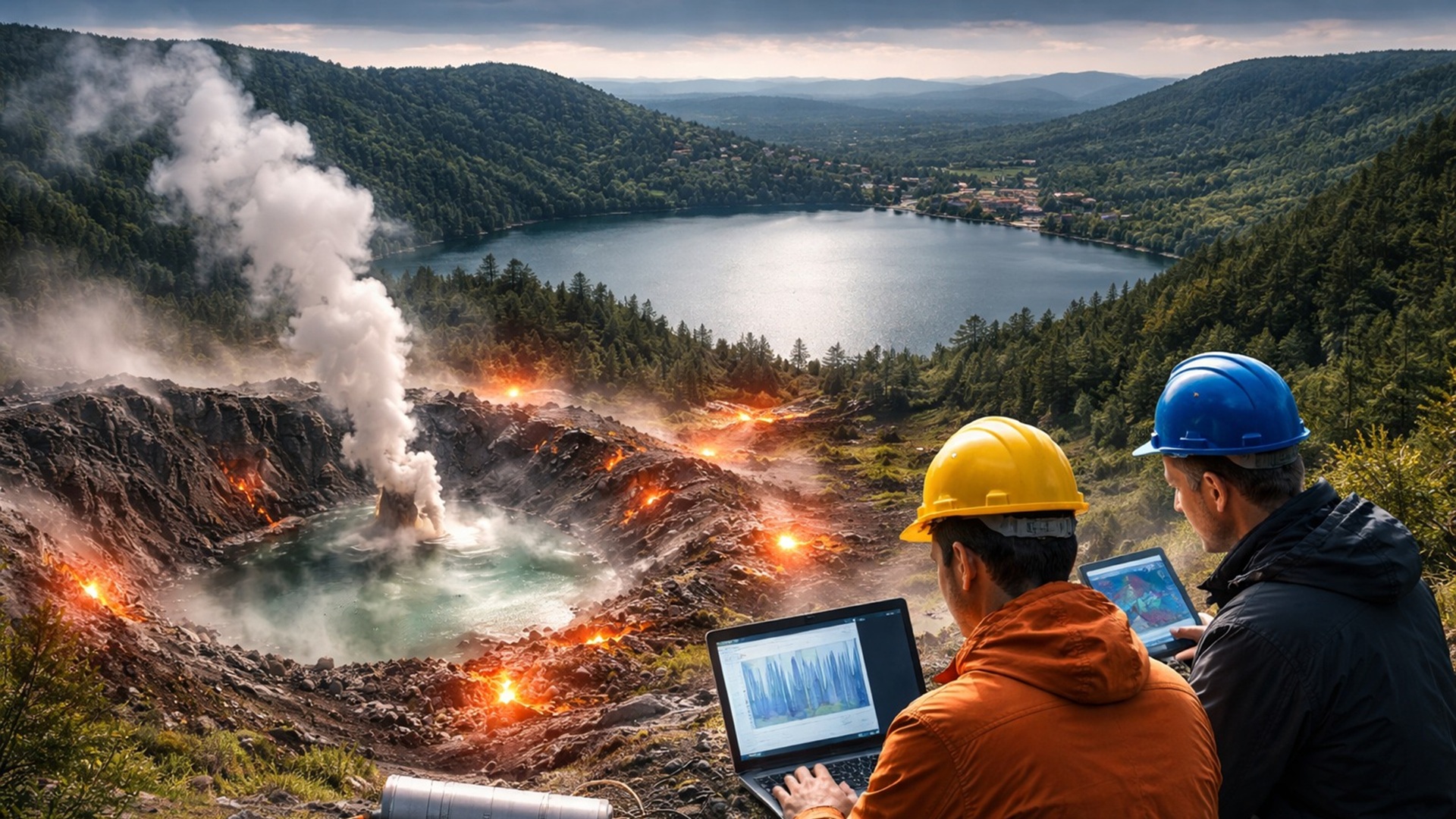
After Recording 1,043 Microearthquakes in the Lake Laach Region, Scientists Mapped an Inclined Subterranean Reservoir Beneath the Volcano and Identified Signs of Pressure and Fluid Movement at Depths Between 10 and 16 Kilometers in the Crust
The dormant volcano of Lake Laach in Germany has attracted scientists’ attention again after recording over a thousand microearthquakes that revealed an inclined subterranean reservoir, suggesting that the geological system beneath the region remains active.
Researchers identified that over a thousand small earthquakes helped to expose a deeper reservoir beneath the Lake Laach volcano. The discovery contrasts with previous models that indicated a vertical body of rock below the volcanic structure.
The new interpretation relates the calm surface of the lake to an active subterranean system that may still be generating pressure inside the crust. However, the data do not indicate that an eruption is near.
-
In 2016, a plane equipped with billions of laser pulses scanned 2,100 km² of jungle in Guatemala and revealed, beneath the tree canopies, a Maya megacity with 61,480 unknown structures, elevated roads spanning dozens of kilometers, industrial-scale irrigation systems, and a population of up to 15 million, three times more than any previous estimate.

-
Someone released 18 beavers in the upper Ebro River; it seemed like an isolated case, but no one knows who did it or how to stop their expansion, and now they have already reached Catalonia. And there’s a detail that changes the game: they can help restore rivers and even capture carbon.

-
ZCC 11000 crane lands at the port of Vitória and heads to Ceará in a convoy with 64 trailers: Zoomlion, founded in 1992, builds a monster that lifts over 600 compact cars to 93 m.

-
The biggest drama of being born on Mars is not breathing: Rice biologist says that colonists’ children may cease to be Homo sapiens, shaped by low gravity, radiation, and isolation that divides humanity.


New Subterranean Map Reveals Inclined Structure Beneath the Volcano
The evidence emerged from the analysis of geological faults buried between Ochtendung, near Koblenz, and Lake Laach. Most of the detected tremors aligned along a narrow zone in this region.
By examining the seismic signals, Torsten Dahm from the Helmholtz Centre for Geological Sciences GFZ mapped a subterranean system different from what was previously imagined.
The study revealed that the reservoir beneath the volcano is inclined towards the Neuwied Basin.
This basin is a valley located in the Rhine region and concentrates many of the small earthquakes recorded during monitoring. The discovered geometry does not prove the proximity of an eruption but suggests an active geological system.
According to the researchers, the new model changes the understanding of the volcano’s subterranean structure and expands the knowledge of the internal dynamics of the volcanic field in the Eifel region.
Network with Over 500 Sensors Investigated Volcano Activity
To study the volcano’s activity, the scientific team installed a network of over 500 sensors along the Eifel hills. In addition, the researchers used a 64-kilometer fiber optic cable as an additional observation tool.
The light traveling through this cable reacts to small deformations and temperature variations in the ground. These changes allow the detection of vibrations that would normally not be captured by traditional seismic networks.
In some points of the network, the distance between the monitoring stations was reduced to about a mile, equivalent to approximately 1.6 kilometers. This density of observation provided the most detailed underground view ever obtained of the region.
With this highly sensitive structure, scientists were able to identify very small geological structures that previous surveys had not been able to distinguish correctly.
More Than a Thousand Microearthquakes Help Explain Volcano Dynamics
During a one-year period, researchers recorded 1,043 microearthquakes in the region of the volcano. These events are so small that they usually go unnoticed by the population.
Most of these tremors occurred at depths between 10 and 16 kilometers below the surface. Many of them occurred in rapid sequences and exhibited similar characteristics, suggesting they may have reused the same rupture area.
This behavior is consistent with systems influenced by fluids in motion within the Earth’s crust. The pressure generated by these fluids can weaken rocks and facilitate the movement of already strained faults.
However, near the southernmost point of the analyzed fault zone, the sequence of tremors exhibited different characteristics. In this location, the events resembled more common seismic aftershocks than a swarm of tremors triggered by fluids.
Seismic Reflections Indicate the Presence of Magmatic Fluids
In other areas below the Neuwied Basin, researchers identified unusual seismic reflections in the rock layers. These signals indicate the possible presence of magmatic fluids accumulated between the subterranean layers.
These fluids may include hot gases and liquids released during the melting process of deep rocks. This material can accumulate between the geological layers over time.
According to Torsten Dahm, the intensity of these reflections suggests that fluids are concentrated in these subterranean layers. It is still unclear whether the material corresponds to actual magma or fluids derived from magma.
The distinction between these two types of material is important for assessing geological risks. A pressurized pocket of molten rock may behave differently from gases or water accumulated in subterranean fractures.
History of the Volcano and Previous Evidence of Activity
The Lake Laach volcano last erupted 13,006 years ago. This event is among the largest eruptions recorded in Europe at the end of the Ice Age.
Since 2013, deeper tremors have been detected at depths between 10 and 40 kilometers below the region of the volcano. These records indicate that fresh material may be rising from deeper seismic zones.
Studies conducted on nearby mineral springs have also detected repeated pulses of gases from deep areas of the crust. These signals suggest that fluid flows continue to be active in the geological system of the region.
When these evidences are analyzed together with the new seismic map, the observed pattern begins to seem less surprising. Researchers believe that the latest data complements clues identified in previous studies.
Subterranean Pressure Alters the Behavior of Geological Faults
The team analyzed with greater precision 192 seismic events recorded during the study. This data indicated that the regional stress field near the volcano exhibits rotation rather than remaining constant.
This behavior can occur in situations of overpressure within the crust. In this scenario, the expanding material pushes laterally against the rocks and alters how geological faults rupture.
Most earthquakes along the main fault exhibited lateral displacement. A smaller group of tremors occurred in the direction of what may be the hidden edge of a subterranean basin.
Some events also propagated towards the surface. This pattern suggests that the local pressure regime may vary significantly in relation to the rest of the region.
Eifel Volcanic Field Requires Continuous Monitoring
The Eifel Peninsula is not formed by a single isolated volcano. It is an extensive volcanic field that includes various ancient craters scattered across the landscape.
In such environments, a potential eruption does not necessarily occur in the same location as the last volcanic activity. Magma can open new pathways and emerge at different points in the volcanic field.
More accurate subterranean maps help guide gas monitoring and seismic tracking in the region. This information can also support land use planning in areas with potential geological activity.
Researchers emphasize that the current model does not yet prove that the reservoir is overpressurized. The earthquake pattern merely indicates that the observed data is compatible with this possibility.
Other explanations are also considered possible, such as pre-existing weakness zones in the crust that direct the earthquakes. To distinguish between these scenarios, new seismic data and more detailed analyses will be necessary.
Even so, the study offers a new baseline for understanding the activity of the Lake Laach volcano. With a more accurate underground overview, future disturbances in the Eifel region can be assessed more clearly.


-

-

2 pessoas reagiram a isso.