 Portuguese
  English
  Spanish
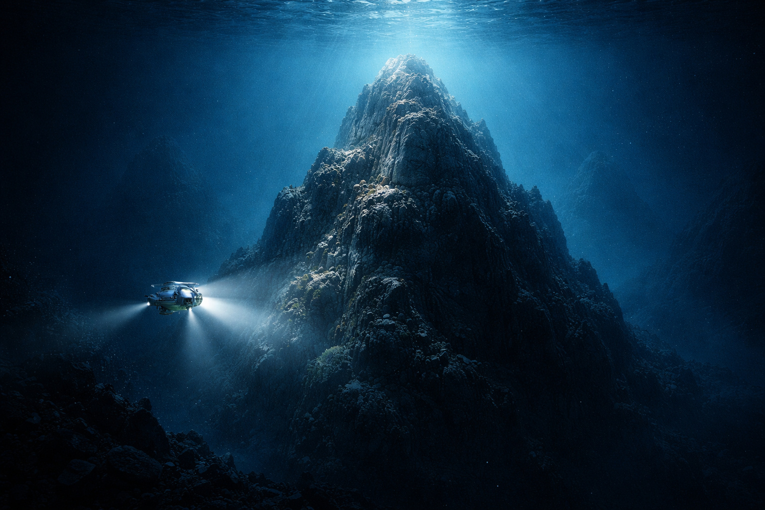
Four submarine mountains have been discovered in the Pacific, the largest at 2,681 meters. The case reveals that 74% of the ocean floor has not been mapped yet.
In January 2024, two technicians aboard the research vessel Falkor (too), from the Schmidt Ocean Institute, were charting the vessel’s route from Golfito, Costa Rica, to Valparaíso, Chile. It was a routine crossing between one project and another. To make the most of the time, they decided to check gravitational anomalies along the way — subtle variations in the ocean surface that may indicate irregularities on the seabed, where a mountain creates an imperceptible relief in the water above it.
What they found at the coordinates made no sense. There was nothing recorded there in any existing oceanographic database. According to the Schmidt Ocean Institute, the multibeam sonar confirmed four submarine mountains completely absent from any global bathymetric map. The largest of them is 2,681 meters tall, covers 450 square kilometers, and was 1,150 meters below the surface. No one, in the entire history of modern oceanography, had recorded its existence.
For reference, 2,681 meters is taller than any peak in the Swiss Alps. The mountain had been there all along, invisible to science.
-
Scientific studies indicate that drought may be strengthening a much greater silent threat: more resistant superbugs.

-
Man builds functional 5-meter submarine in his garage using gas cylinders, PVC pipes, and a refrigerator motor, and navigates with the vessel on a lake in Colombia.

-
Millions of people have been eating yam for centuries without knowing that this humble tuber contains a compound called diosgenin, which scientists have now discovered can improve memory and help control blood sugar levels.

-
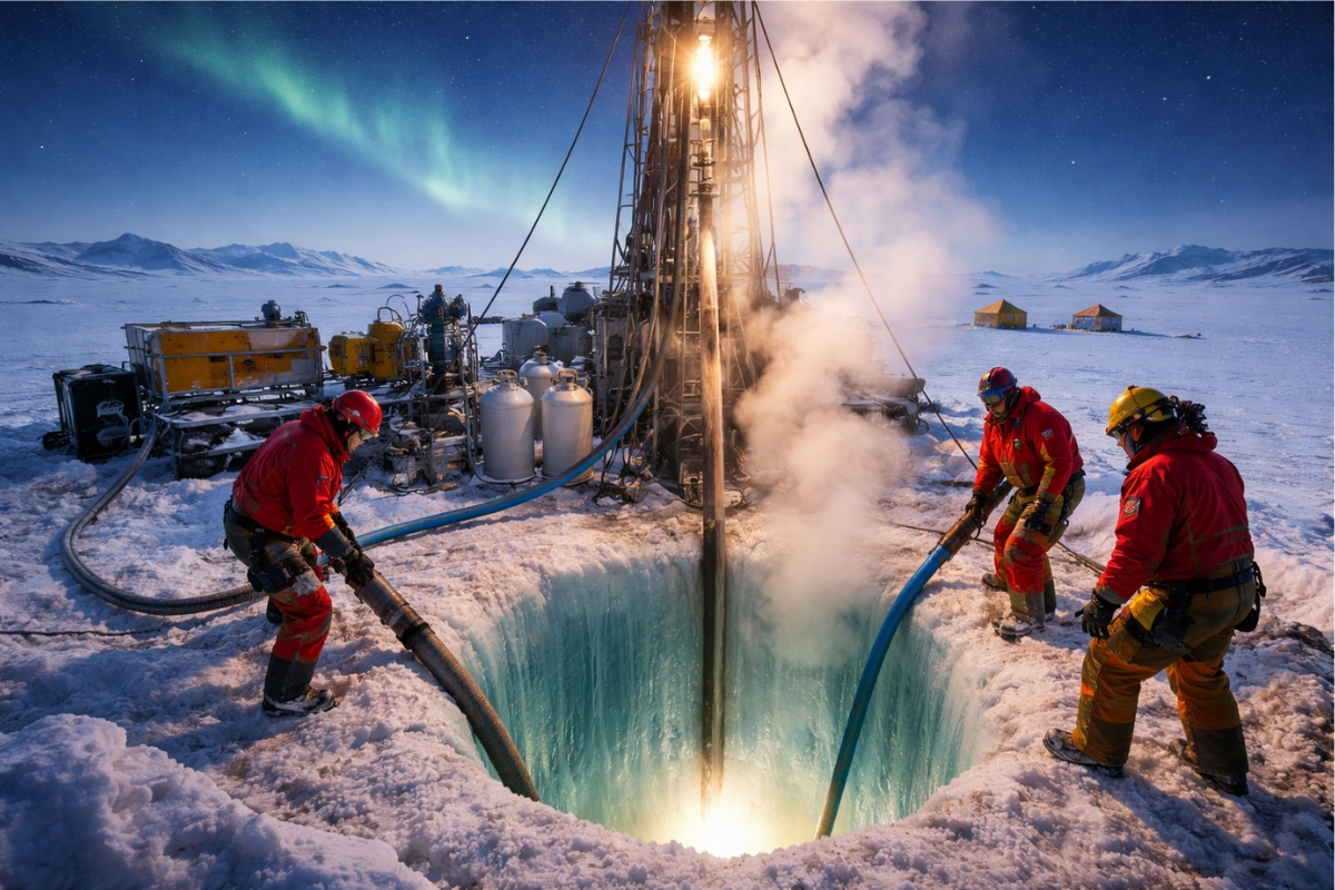
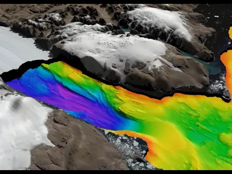
Scientists from an international project drill 1,800 meters of ice in Antarctica using hot water and discover details about one of the most intriguing places on planet Earth.

The ocean floor covers 71% of the planet, but has not been mapped for the most part
The ocean floor covers approximately 361 million square kilometers — about 71% of the Earth’s surface. In 2017, when the Nippon Foundation and GEBCO launched the global Seabed 2030 project, the goal was to completely map the ocean floor by the end of the decade. At that time, only 6% of that area had been mapped with modern resolution.

This means that there was no detailed map of 94% of the planet. For comparison, the surface of Mars has been almost entirely mapped with resolutions of up to a few meters per pixel. The Moon has been photographed with centimeter accuracy. The ocean floor of Earth, where most of the planet’s biosphere resides, remained largely unknown.
This lack of knowledge is not due to a lack of scientific interest. It is a physical and technological limitation.
Why mapping the ocean floor is one of the greatest scientific challenges on Earth
Sunlight does not penetrate the water beyond a few hundred meters, making it impossible to map the ocean floor using traditional optical methods. The process relies on sonar, a system that emits sound pulses and measures the time it takes for the echo to return, calculating depth based on the speed of sound in water.
To obtain sufficient resolution to identify structures around 100 meters, a ship needs to navigate slowly in parallel paths, covering each strip of the ocean with precision. Considering that the average depth of the oceans is approximately 3,500 meters and that regions like the Mariana Trench exceed 11,000 meters, the logistical challenge becomes extreme.
NOAA estimated that a single ship would take about 350 years to map 93% of the ocean floor with modern technology. The global cost to carry out this work with the entire available fleet ranges from 3 to 5 billion dollars, a value comparable to interplanetary missions.
Seabed 2030 project advances with global collaboration, but 74% of the oceans still remain unmapped
Unlike large centralized programs, Seabed 2030 operates as a collaborative global network. The project collects data from any vessel equipped with sonar that is willing to share information, including commercial ships, research vessels, cruise ships, and even fishing boats.
Fishermen contribute navigation data. Cargo ships that regularly cross ocean routes send measurements. Institutions from over 200 countries have made historical databases available. In 2023, the British company ARGANS contributed altimetry data covering 8,000 square kilometers of remote areas.
This model has allowed for accelerated mapping. In 2019, coverage increased from 6% to 15%. In 2022, it reached 23.4%. In 2024, it hit 26.1%, with 4.34 million square kilometers added in just one year. Still, about 74% of the ocean floor remains without detailed mapping.
How gravitational anomalies reveal invisible mountains on the seabed
The discovery of the four submarine mountains illustrates an increasingly used method to locate unknown structures on the ocean floor. Satellites can measure millimeter variations in sea surface height. These variations are not random: they are caused by the gravity of underwater structures.
A submerged mountain creates a slight “bulge” in the ocean surface above it. A depression generates the opposite effect. With this data, scientists can map gravitational anomalies and identify regions that may hide unknown reliefs.
It was exactly this method that led the Falkor (too) technicians to the coordinates where the mountains were found.
The altimetry indicated irregularities but did not reveal details. The multibeam sonar confirmed four distinct structures, with heights ranging from 1,591 to 2,681 meters. None of them were listed in any global database.
Seamounts harbor unknown ecosystems and extreme biodiversity
Submarine mountains are not just geological formations. They function as biodiversity hotspots. The ocean currents that interact with their slopes create upwelling zones, where deep, nutrient-rich waters rise toward the surface.

This process sustains complex ecosystems. Deep corals attach to rocks, forming structures that harbor hundreds of species. Estimates suggest that the number of known seamounts could jump from 44,000 to as many as 100,000 with new data from satellites like SWOT.
Recent expeditions in the Southeast Pacific identified over 300 new species in newly mapped regions. In one of the dives, a Promachoteuthis squid, extremely rare and known only from a few specimens collected over more than a century, was recorded for the first time on video.
Lack of detailed maps of the seabed impacts internet, tsunamis, and global infrastructure
The ignorance of the ocean floor has direct consequences for global infrastructure. About 99% of international internet traffic depends on submarine fiber optic cables, which need to be installed on safe routes, away from rugged terrain and seismic zones.
Without accurate maps, these routes are planned based on incomplete data. Tsunamis are also affected by the topography of the seabed, which influences the speed and direction of the waves. More accurate forecasting models depend directly on detailed bathymetric maps.
Ocean currents, coastal storms, and even global climate patterns are influenced by interactions with underwater reliefs that, for the most part, have yet to be recorded.
Global race to map the oceans relies on drones and artificial intelligence
With 74% of the ocean floor still unknown and a target set for 2030, Seabed 2030 relies on technological advances to accelerate the process. One of the main bets is the use of autonomous surface drones, such as those developed by the company Saildrone, capable of operating for months without a crew and mapping depths of up to 7,000 meters.

Another front is the use of artificial intelligence. Researchers are utilizing neural networks to reprocess old data, extracting more detailed information from surveys conducted decades ago when technology was limited.
These two approaches are seen as essential to reduce the time needed to map the planet, but there is still no guarantee that the 2030 target will be met.
New discoveries indicate that the ocean floor still hides thousands of unknown structures
The four mountains discovered in January 2024 were not an isolated case. In August of the same year, a submarine mountain of 3,109 meters was identified in the Nazca Ridge. In 2023, another one measuring 1,600 meters was found off the coast of Guatemala.
The pattern repeats in all discoveries: data indicate an anomaly, the route is adjusted, and the sonar reveals completely unknown structures. This raises an inevitable question: it is no longer a matter of whether there are more unknown submarine mountains, but how many remain hidden.
With 74% of the ocean floor still without detailed mapping, most of the planet continues to be a territory that humanity has yet to explore.


Seja o primeiro a reagir!