 Portuguese
  English
  Spanish
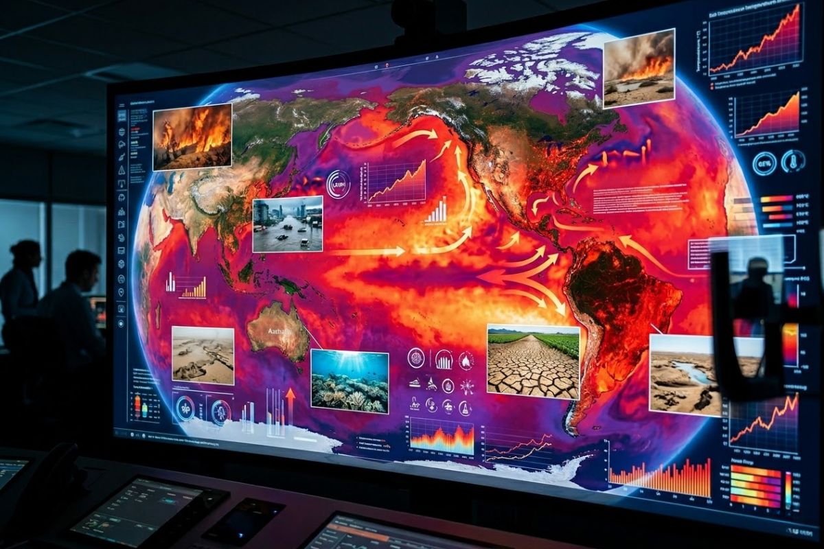
WMO Report, linked to the UN, points to record energy imbalance: the Earth absorbs more heat than it returns, with warming oceans, retreating ice, and increasing extreme events. Scientists warn that the El Niño expected for 2026 could push new records until 2027 and intensify impacts felt in Brazil.
The latest UN alert places El Niño at the center of an already pressured scenario: the Earth is accumulating heat at an unprecedented rate because it is retaining more thermal energy than it can “return” to space. In practice, this raises air temperature, warms the surface, and, mainly, loads the oceans with most of this extra energy.
The World Meteorological Organization (WMO) describes this situation as a record-level “energy imbalance,” driven by greenhouse gases such as carbon dioxide. The concern is that the combination of human-induced warming and an El Niño in the second half of 2026 amplifies the chance of new global records, with repercussions on extreme weather and daily impacts.
What does it mean for the Earth to “accumulate heat” and why has this become a red alert

When the WMO talks about energy imbalance, the idea is straightforward: a lot of energy from the Sun enters, and a larger portion than normal gets “trapped” in the climate system, instead of going back into space. This excess is not abstract: it manifests as additional heat distributed among the ocean, atmosphere, land, and ice, and it is precisely this sum that helps explain why so many climate indicators appear at critical levels simultaneously.
-
Millions of people have been eating yam for centuries without knowing that this humble tuber contains a compound called diosgenin, which scientists have now discovered can improve memory and help control blood sugar levels.

-
Scientists from an international project drill 1,800 meters of ice in Antarctica using hot water and discover details about one of the most intriguing places on planet Earth.
-
Seen from space, a colossal volcano nearly 5,000 meters high in Russia has released 1,600 km of smoke over the Pacific, forming “devil’s horns” of lava and revealing the brutal force of the Ring of Fire.
-
Expedition 501: Scientists drill into the ocean floor and discover a giant reserve of fresh water hidden beneath the sea, extracting nearly 50,000 liters and revealing an invisible system that could reshape the map of water scarcity.


The WMO associates the recent record of this imbalance with the high concentration of gases that retain heat, especially CO₂, at levels not seen for at least two million years. This is not a technical detail: it is the central mechanism that pushes the thermometer up even when there are natural variations from year to year, such as La Niña and El Niño.
Where most of the heat goes: the ocean as the planet’s “depository”
The data that changes the way we see the problem is the distribution of extra heat: more than 90% of the additional energy stays in the oceans, while a smaller fraction warms the land and atmosphere, and another part contributes to ice melting. This means that the ocean is the great buffer and also the great “archive” of warming, accumulating heat that can influence the climate for long periods.
The WMO indicates that the heat stored in the upper 2 km of the global ocean has reached a new record and that, in the last two decades, the rate of warming has been more than double that observed at the end of the 20th century. This storage has chain consequences: it harms marine ecosystems, contributes to sea level rise, and can favor more intense storms. In other words, what happens in the ocean does not stay in the ocean.
Recent records: why 11 consecutive years at the top matter for the next cycle
According to the WMO, the last 11 years have also been the 11 warmest since records began in 1850. This type of sequence alters the “starting point” of each new year: when the baseline is already elevated, any additional natural or emission-driven push tends to produce more visible and faster effects.
In this context, the WMO points out that 2025 was about 1.43 °C above pre-industrial levels. At the same time, a temporary cooling associated with La Niña helped explain why 2025 did not surpass 2024, which had been intensified by the opposite phase, El Niño. The central reading is that natural variability continues to exist, but it is “operating” on a warmer baseline than before.
El Niño: why the warm phase could push temperatures until 2027
The El Niño is the warm phase of the phenomenon known as El Niño-Southern Oscillation (ENSO), which links changes in the ocean and atmosphere. Physically, it involves warmer waters in the equatorial Pacific and changes in atmospheric circulation, often associated with the weakening of trade winds. It is not “the cause” of global warming, but it can temporarily amplify the ongoing warming, raising global averages.
The WMO reports that long-term forecasts indicate a strong possibility of a warming El Niño phase forming in the second half of 2026.
The concern is explicit: an El Niño combined with warming caused by human activities could raise temperatures until 2027, increasing the chance of new global records. When the “floor” is already high, reaching the peak becomes easier — and harder to ignore.
Impacts already observed: extremes, retreating ice, and indirect health risks
The same warming that raises averages helps intensify different types of extreme events. The WMO cites that glaciers around the world had one of the five worst years on record in 2024/25 and that sea ice at both poles remained at minimal levels or close to it for much of 2025. Ice acts as a climate regulator; when it shrinks, the system loses an important layer of stability.
Moreover, the report links rising temperatures to effects such as more intense storms and conditions favorable to the spread of diseases, including dengue.
A recent example mentioned is a record heatwave in the southwestern United States at the beginning of the season, with temperatures exceeding 40 °C in some places and remaining about 10 °C to 15 °C above average; a quick analysis by the World Weather Attribution group concluded that this intensity would be “virtually impossible” without human-caused climate change. The message behind the example is simple: what was once rare tends to become more likely.
El Niño and La Niña in Brazil: how ENSO usually affects rain and temperature
In Brazil, the phases of ENSO usually reorganize patterns of rain and temperature, especially between the end of winter and summer. The description is a game of signals: La Niña tends to make rains more irregular in the South (with a higher risk of drought) and increases precipitation in the North and Northeast; it can also favor below-average temperatures by facilitating the passage of cold fronts, helping to explain milder summers in some regions.
On the other hand, El Niño usually reinforces heat across the country and reverses the pattern of rainfall: in the North and Northeast, precipitation tends to be below average, while in the South it tends to be above average. This does not mean that every city will have the same outcome, but it points to a direction of risk and, on a warmer planet, these patterns can combine with heatwaves, droughts, or storms in a more problematic way.
The UN alert, via WMO, combines two forces that usually weigh on the climate: sustained global warming driven by greenhouse gases and the possibility of an El Niño starting in the second half of 2026, capable of raising global temperatures until 2027.
In a scenario of recent records and oceans storing most of the extra heat, the risk is not just “more heat,” but more instability and more cascading impacts.
With information from the portal BBC.
I want to hear from you: in your region, have you noticed clearer changes in heat, rain, or droughts in recent years? And when El Niño appears, what usually changes first: temperature, rain, health, routine? Leave your comments with your city/state.


Seja o primeiro a reagir!