 Português
  Inglês
  Espanhol
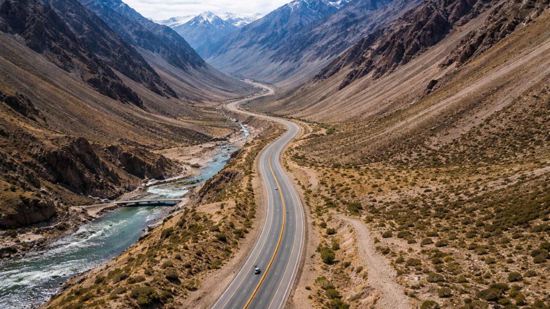
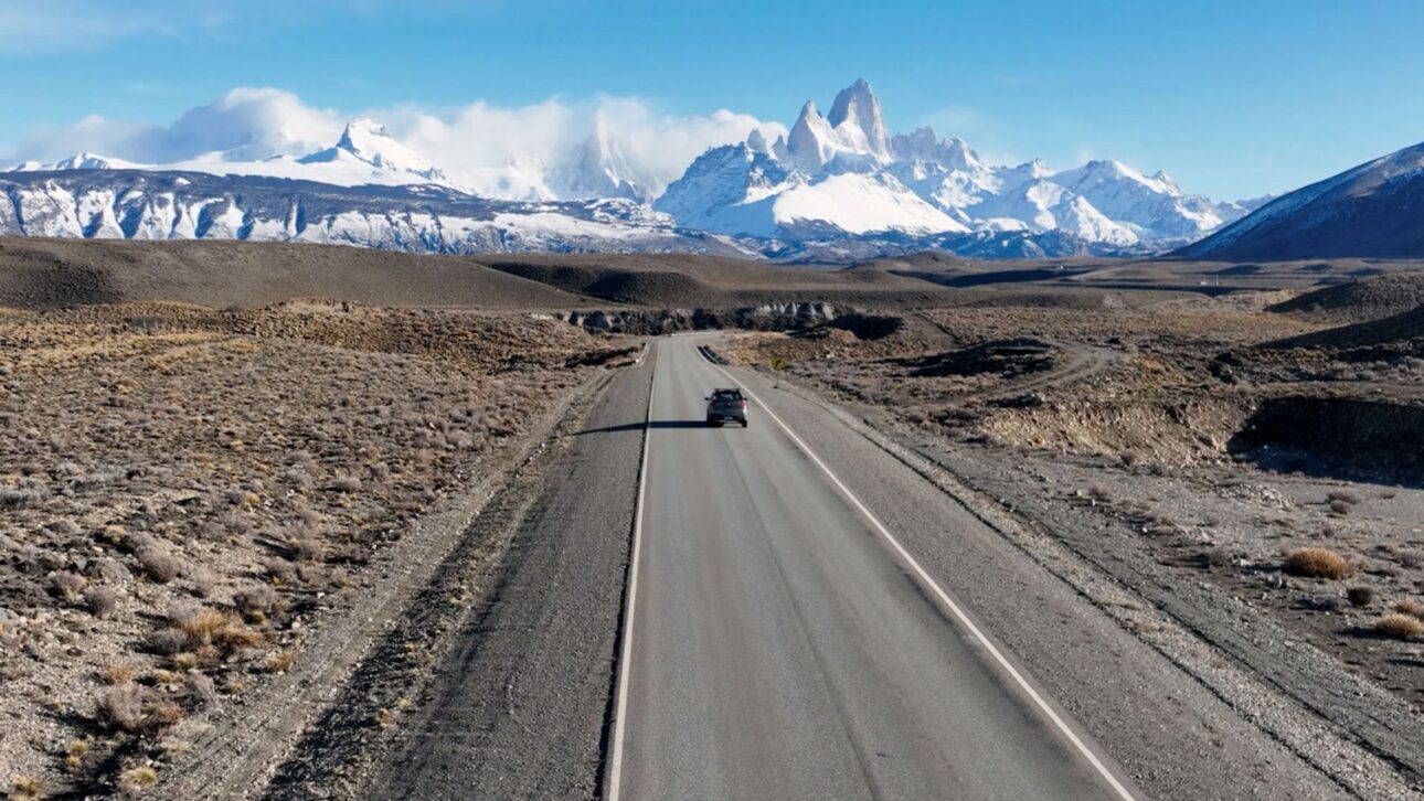
The Longest Highway in Argentina Runs 5,194 Km Alongside the Andes Mountain Range, Crossing 11 Provinces, 27 Mountain Passes, and 236 Bridges, While Providing Access to Over 20 National Parks Between the Vineyards of Mendoza and the Glaciers of Patagonia.
Route 40 Crosses Argentina from the Extreme North to the Deep South over 5,194 Km, Making It the Longest Highway in the Country and One of the Most Imposing in the American Continent.
The path runs parallel to the Andes Mountain Range, connecting 11 provinces and crossing 27 mountain passes along a route that reaches 4,895 meters above sea level at its highest point.
Established in 1935 from the unification of old regional trails, the road crosses 236 bridges over 18 major rivers and provides access to over 20 national parks distributed along its length.
-
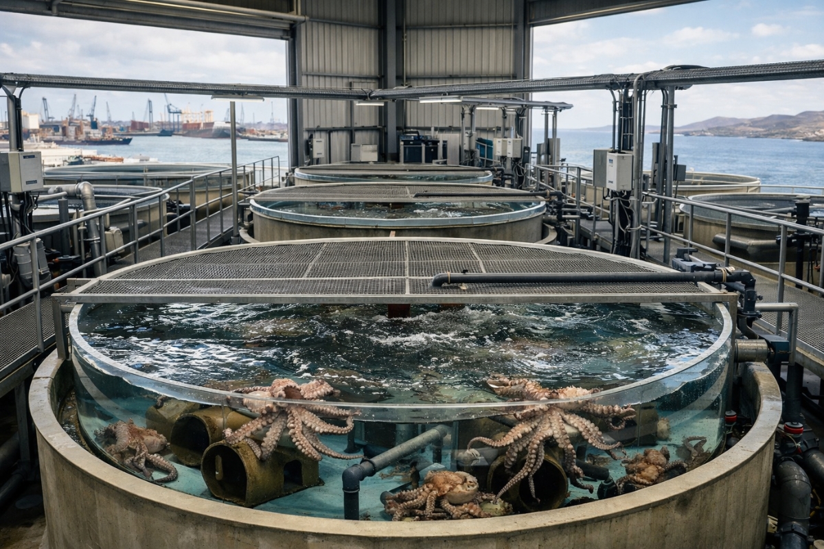
The world’s first octopus farm wants to open in the Canary Islands and is already provoking an international reaction: the plan aims to produce 3,000 tons per year.
-
Drought may be creating stronger superbugs in the soil and helping antibiotic resistance reach hospitals, warns a study highlighting a problem that could grow alongside extreme weather.

-
The biggest scam in history: Napoleon’s France deceived the United States by selling them a territory that was Spanish.

-
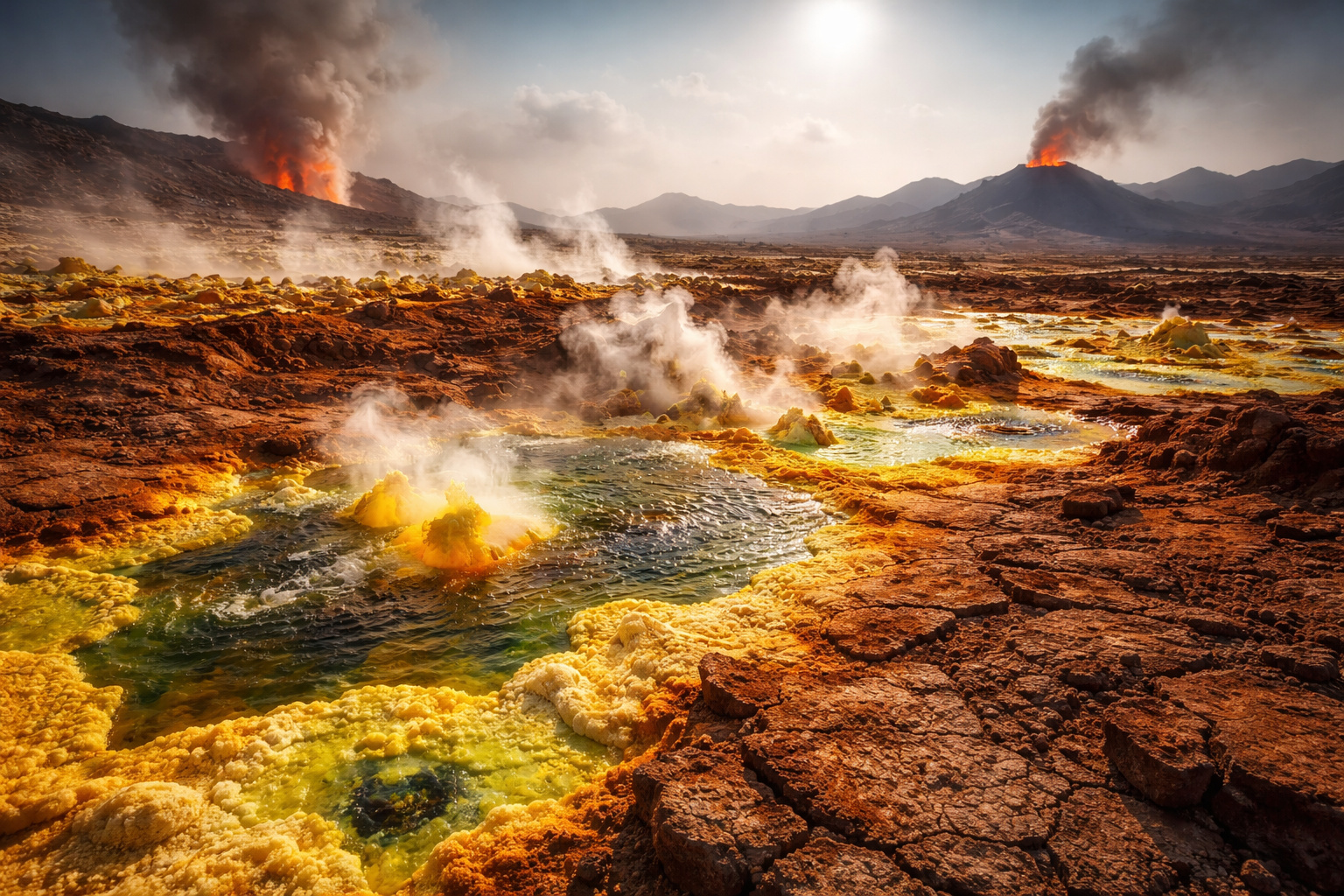
Why is the Danakil Desert so dangerous? It has unstable terrain and how extreme temperatures and toxic gases turn the region into one of the most hostile environments on Earth.

The Scale of the Route Challenges the Conventional Concept of Highways, Transforming the Journey into a Geographic and Cultural Expedition Through a Country of Continental Proportions.
Historical and Natural Destinations Along the Route
The Vineyards of Mendoza Are Among the Most Well-Known Stops on the Highway’s Central Stretch, Attracting Wine Tourists and Travelers Seeking to Combine Nature and Regional Cuisine.
However, the Variety of Landscapes That Route 40 Offers Goes Far Beyond the Vineyards: The Argentine North Reveals the Multicolored Mountains of Salta and the Vast Salt Flats Characterizing the Andean Altiplano.
At the Extreme South, the Absolute Highlight Is Access to the Perito Moreno Glacier in El Calafate, Considered One of the Most Impressive Natural Wonders of the Entire American Continent.
The Ice Mass Advances Over Lago Argentino and Periodically Collapses in Spectacular Calving Events That Attract Tourists and Researchers from Around the World.
Moreover, the Highway Passes by the Cueva de las Manos, an Archaeological Site That Preserves Rock Paintings Over 9,000 Years Old.
This Site Is Recognized as a UNESCO World Heritage Site and Represents One of the Best Preserved Records of Prehistoric Human Presence in South America.
Essential Planning to Cross the 27 Mountains
The Crossing of Route 40 Requires a Robust Vehicle and Thorough Planning of Refueling Points, Especially in the Remote Segments of Patagonia, Where Hundreds of Kilometers Can Separate One Gas Station from the Next.
Altitude and Temperature Variations Along the Route Are Extreme, with Strong Winds and Sudden Snow Capable of Changing Road Conditions in Just Hours.
The Road Infrastructure Varies Considerably Along the Way. Sections of Impeccable Asphalt Alternate with Long Stretches of Gravel—The Compacted Gravel Characteristic of Southern Argentina—Which Requires Reduced Speed and Increased Attention from the Driver.
On the Other Hand, This Variation Is an Essential Part of the Experience That the Road Provides to Those Who Choose to Traverse It.
Motorcyclists and Adventurers from Different Countries Choose Route 40 as Their Ultimate Destination, Attracted by the Combination of Freedom, Isolation, and Grandeur of the Landscapes.
Even So, It Is Imperative for Travelers to Be Prepared to Face Sections Without Signal Coverage, Without Service Stations, and with Almost Nonexistent Support Infrastructure for Hundreds of Consecutive Kilometers.
Contrasts Between the Arid Northern Section and the Frozen Southern Section
The Northern Segment of Route 40 Is Defined by Winding Roads That Ascend Toward High Altitudes, Reaching Nearly 5,000 Meters at Abra del Acay, One of the Highest Mountain Passes in the World Accessible by Conventional Vehicles.
The Arid and Hot Climate Imposes Severe Temperatures During the Day, While Nights at High Altitude Register Sharp Drops That Surprise Unprepared Travelers.
The Andean Culture Permeates the Entire Northern Region, with Local Markets, Traditional Festivals, and Colonial Architecture That Contrast with the Aridity of the Surrounding Landscape.
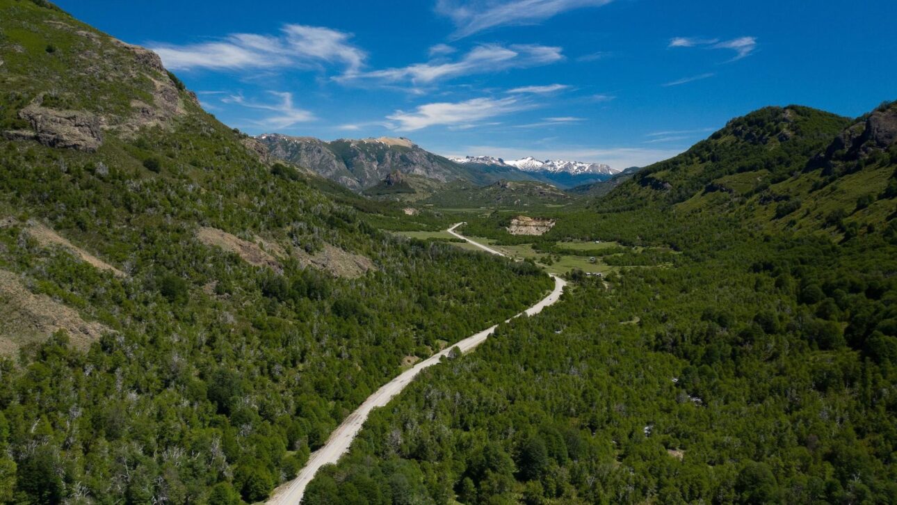
Meanwhile, the Transition to the South Occurs Gradually, with Vegetation Becoming Increasingly Sparse Until It Nearly Disappears in the Patagonian Steppe.
In the Southern Section, Almost Infinite Straits Cut Through the Landscape in Silence. Guanacos, Rheas, and Pumas Frequently Cross the Road, Reminding Travelers They Are Traversing One of the Most Remote and Wild Regions on the Planet.
Intensely Blue Lakes, Such as Lago Argentino and Lago Nahuel Huapi, Appear as Unexpected Interruptions in the Monotonous Gray of the Patagonian Steppe.
National Parks Accessible via the Historic Highway
Route 40 Offers Direct Access to Over 20 National Parks, Each with Unique Ecosystems and Its Own Infrastructure for Camping, Trails, and Wildlife Observation.

Among the Most Visited Is the Talampaya National Park in Northeast Argentina, with Its Reddish Rock Formations That Reach 150 Meters in Height and Preserve Fossil Records from the Triassic Period.
In the Far South, Los Glaciares National Park Is Home to the Perito Moreno and Other Icefields That Form One of the Largest Glacial Reservoirs Outside the Poles.
Each of These Reserves Represents an Irreplaceable Fragment of Argentine Biodiversity, Protected by Legislation That Restricts Economic Development Within Its Boundaries.
Furthermore, the Density of Protected Areas Along the Route Reveals a Consistent Conservation Policy That Has Transformed the Highway into an Ecological Corridor of Continental Importance, Attracting Researchers and Environmentalists from Around the World to Study Its Unique Ecosystems.
Official Data That Reveals the Scale of the Mega Highway
The Indicators from Argentina’s Ministry of Tourism and the National Geographic Institute Confirm the Size of Route 40.
With Its 5,194 Km Length, It Is the Longest Highway in the Country and Covers a Territorial Span Equivalent to the Distance Between Lisbon and Moscow.
The Maximum Altitude of 4,895 Meters Recorded at Abra del Acay Surpasses the Summit of Several European Peaks, Placing the Highway Among the Routes with the Greatest Altimetric Variation on the Planet.
The 236 Viaducts Over 18 Major Rivers Reinforce the Engineering Complexity Involved in the Construction and Ongoing Maintenance of This Route.
Understanding the Scale of Route 40 Is the First Step in Crafting a Realistic Itinerary. Traversing the Country from End to End Can Take Weeks, Depending on the Selected Stops and Weather Conditions Along Each Stretch.
The Data Also Reflects the Economic Diversity of the Argentine Provinces, from Fine Wine Production in Mendoza to Mineral Extraction in the Extreme Northern Andes.


-

Uma pessoa reagiu a isso.