 Portuguese
  English
  Spanish
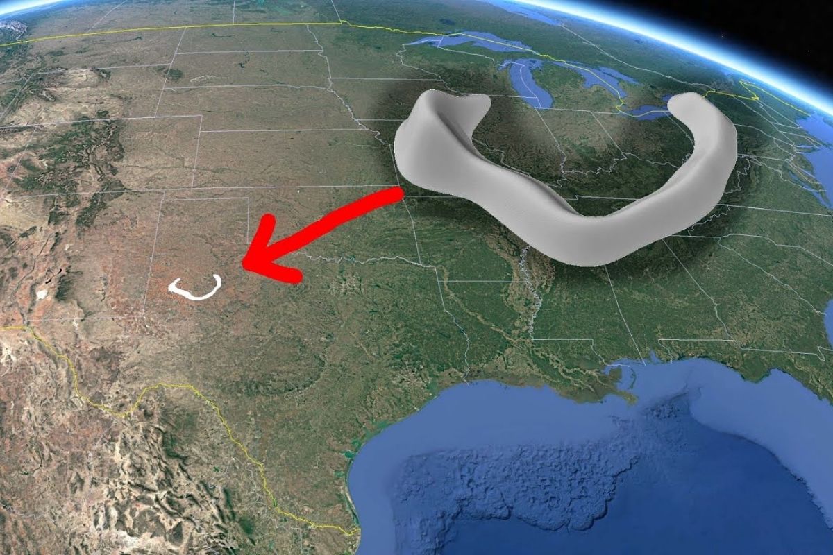
Buried About 8,000 Feet, The Fossilized Reef Of West Texas Was Identified By Seismic Lines In 1936 And Confirmed By Drilling In 1938 And 1948. The Horseshoe Structure Measures 90 By 60 Miles, Passes Beneath Lake JB Thomas, And Has Supported 2.7 Billion Barrels.
In 1936, seismic lines acquired in West Texas pointed to an anomaly too large to be ignored: a fossilized reef in a horseshoe shape, hidden about 8,000 feet deep and partially beneath Lake JB Thomas. The signal intrigued geophysicists and geologists and led to the drilling of a well in 1938 to verify, in the rock, what the records indicated.
The confirmation came in stages. After the first well in 1938, new data and another drilling about five years later expanded the reading of the structure. In 1948, a core sample drilling showed that the darker pieces of limestone were fossilized algae, helping to date the formation between 300 and 270 million years. From then on, the fossilized reef was treated as a large underwater atoll in Texas, associated with fields totaling 2.7 billion barrels.
What The Seismic Lines Saw Beneath Lake JB Thomas

The fossilized reef did not appear by chance.
-
Motorola launched the Signature with a gold seal from DxOMark, tying with the iPhone 17 Pro in camera performance, Snapdragon 8 Gen 5 that surpassed 3 million in benchmarks, and a zoom that impresses even at night.

-
Satellites reveal beneath the Sahara a giant river buried for thousands of kilometers: study shows that the largest hot desert on the planet was once traversed by a river system comparable to the largest on Earth.

-
Scientists have captured something never seen in space: newly born stars are creating gigantic rings of light a thousand times larger than the distance between the Earth and the Sun, and this changes everything we knew about stellar birth.

-
Geologists find traces of a continent that disappeared 155 million years ago after separating from Australia and reveal that it did not sink, but broke into fragments scattered across Southeast Asia.

The reading began with seismic waves generated in the terrain and recorded by receivers on the surface, in a process compared to a subsurface ultrasound.
In the old technique, shallow wells were drilled and dynamite detonated to create seismic waves.
In the modern technique, trucks induce strong vibrations in the ground; the return of these waves is captured by geophones, sent to a recording truck, and processed later to form an image of the Earth’s interior.
A modern seismogram example illustrates the principle: thin bands indicate rock layers, with dark bands that can be tens of meters thick.
The difference is that, in 1936, the seismic lines were still of inferior quality, and professionals did not even imagine the scale of the structure beneath Texas.
It was in this scenario that, around 1936, seismic lines were acquired in the area of Lake JB Thomas.
When geophysicists and geologists examined the seismic lines crossing the feature, they saw a signature outside the regional pattern and set out to verify through drilling in 1938.
From The Well Of 1938 To The Discard Of Caldera And Crater

The drilling of 1938 brought a decisive piece of data: the fragments circled in the well indicated limestone.
The presence of limestone shifts the debate to clear, warm marine environments, and also weakened hypotheses such as volcanic caldera, since no volcanic rocks were observed in the recovered material.
The initial discussion went through direct comparisons.
The scale was described as gigantic, estimated to be about twice the size of the Yellowstone caldera.
The alternative hypothesis was an impact crater, due to geometric similarity with known craters and because there are craters in limestone.
But, with the acquisition of more seismic data over the years and the comparison between drillings, the impact interpretation was discarded.
Decades later, modern seismic refined the contour of the top of the limestone, reinforcing that it was a sedimentary structure linked to the fossilized reef in Texas.
The Core Of 1948 And The Clue Of Fossilized Algae
The leap of 1948 was the acquisition of core samples, allowing a direct view of the rock.
Much of the material had the appearance of “potato chip,” which could suggest fragmented rock, but examination pointed to a biogenic component.
The darker pieces were fossilized algae, described as phylloid algae similar to lettuce, made of calcite and capable of accumulating sediments between fronds and building successive layers until consolidating into a massive structure.
This explains why the fossilized reef is associated with builders different from modern coral, with coral described as rare in this record.
With this set, it was also possible to date the fossilized reef between 300 and 270 million years, a range associated with the Pennsylvanian and the early Permian, when phylloid algae appear as one of the main “reef builders.”
Dimension, Shape And Position: Why The Horseshoe Surprises In Texas
The fossilized reef is described as a feature about 90 miles east to west and 60 miles north to south.
The edge usually has a width of 9 to 10 meters, and the relief is substantial: typically around 1,500 feet, reaching nearly 3,000 feet.
The detail that changes the game is the depth.
The top of the fossilized reef generally lies 8,000 feet below the surface, which helps explain why the discovery depended on seismic lines and drillings.
Part of the horseshoe lies beneath Lake JB Thomas, an artificial reservoir, creating the contrast between a flat landscape on the surface of Texas and a monumental geometry underground.
Why Geologists Called The Structure Horseshoe And Treated It As Atoll
As more seismic lines were acquired and more wells drilled, geologists reconstructed the complete picture and, upon seeing size and shape, named the feature Horseshoe.
The interpretation relies on limestone, atoll morphology, and a biological signature from fossilized algae, connecting shape and process to the fossilized reef in Texas.
The explanation includes physical limitations that help understand atoll architecture: corals depend on sunlight, which limits the depth of development, and the subsidence of the ocean floor and relative sea level changes reorganize growth and filling.
There is also a rare scale reference: the structure is described as about four times larger than the largest current atoll cited in the Pacific, reinforcing why the fossilized reef became an object of comparison and study, even buried beneath Texas and under Lake JB Thomas.
How A Fossilized Reef Becomes A Petroleum Trap
The fossilized reef is relevant not only for its geometry.
It is described as an ideal location for oil to accumulate, by combining porosity in the carbonate body with sealing by thin rocks.
The progressive filling around the reef with sediments, including shales rich in organic matter, creates conditions for the generation and migration of hydrocarbons.
The description details the source rock in dark shales with organic matter primarily associated with plankton and highlights special conditions to preserve this content: low-oxygen water and low clay influx, so as not to dilute the organic matter.
It also describes that reefs can be suffocated by muddy water, which interrupts growth and opens the way for sediment packages that then function as seals.
The generation mechanism is described objectively: when the system reaches about 9,000 to 10,000 feet, with temperatures around 150 to 300 degrees Fahrenheit, organic matter begins to convert to oil, is expelled from the shale, and migrates to the porosity of the fossilized reef.
The upper shale acts as a seal and keeps the fluid trapped; being less dense, oil tends to occupy the top of the structure, like a bubble.
The Balance Of 2.7 Billion Barrels And The Post-War Effect In Texas
Main field maps associated with the horseshoe atoll indicate that production reached about 2.7 billion barrels.
This volume, associated with the fossilized reef, is treated as a milestone of the so-called Texas Reef Boom, with a significant impact on the post-World War II economy.
The consolidated operational pattern combines seismic lines to define geometry, drillings to confirm limestone and porosity, and impermeable rocks to seal the trap.
The fossilized reef, therefore, enters history not only as an anomaly beneath Lake JB Thomas but as geological architecture capable of concentrating 2.7 billion barrels in connected fields in Texas.
The case of the fossilized reef beneath Lake JB Thomas shows how seismic lines, drillings, and core samples transform a discreet signature into a complete narrative about ancient Texas and its resources.
For those following geosciences and energy, the most useful action is to compare new seismic images with historical data before accepting ready-made explanations about “subsurface anomalies.”
If you could see a seismic image of the subsurface of your region, what kind of anomaly would you find most likely: fossilized reef, crater, or something completely different?


-

-

-

-

5 pessoas reagiram a isso.