 Portuguese
  English
  Spanish
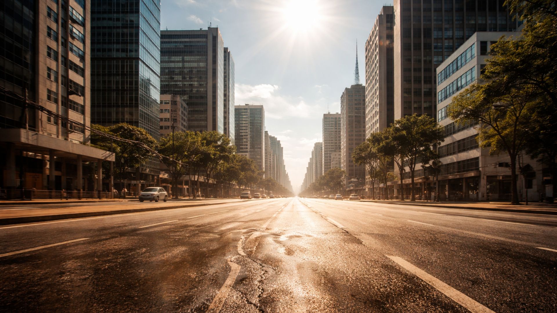
Persistent Heat Keeps Alert In South-Central Regions, With Highs Near 40 °C, Health Risk, And Atmospheric Blockage That Hinders The Arrival Of Cold Fronts, Prolonging Stuffy Days, Little Wide Rain, And Thermal Discomfort In Large Cities.
A heat wave continues to raise temperatures in areas of South-Central Brazil this Friday (26), with expected highs near 39 °C in capitals such as Rio de Janeiro and São Paulo, and with a health risk warning issued by the National Institute of Meteorology (Inmet).
The situation occurs after consecutive days of above-normal heat for the season, a condition that, according to criteria used by the agency, characterizes a heat wave when the maximum temperature remains more than 5 °C above the climatological average for more than five days.
Throughout the week, Inmet has been indicating a orange alert for danger in part of the country.
-
The Argentine government celebrates the lowest poverty rate in 7 years, but experts warn that the methodology has changed, real wages have fallen, unemployment has risen, and the number of people on the streets of Buenos Aires has increased by 57% since Milei took office.

-
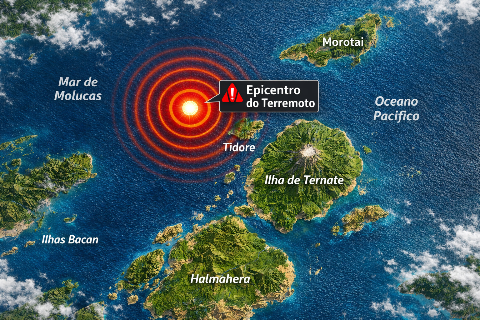
7.8 magnitude earthquake in Indonesia frightens the population, triggers tsunami alert, and hits an island with over 200,000 inhabitants this Thursday.
-
Google will finally let you change that embarrassing Gmail address you created in your teenage years without losing any accounts, logins, or old emails: the feature is already available in the United States.

-
Heading to Brazil in a Bonanza F33 single-engine aircraft: a couple departs from Florida on a visual flight, makes technical stops in the Caribbean to refuel and organize paperwork, and begins the staged crossing until they reach the country.


However, on the morning of this Friday, the institute updated the situation and classified it as a red alert of great danger for areas in the Southeast, maintaining a warning of intense heat also in sections of the South and the Midwest, with validity indicated until Monday (29) in the most affected areas.
Atmospheric Blockage Sustains Off-Pattern Heat
Meteorologists point out that an atmospheric blockage has favored the persistence of warm air and reduced the entrance of cold fronts, limiting broader relief from the temperatures.
With less widespread rain and more open sky during several periods of the day, the combination of strong sun and warm air keeps maximum temperatures high and makes nights more stuffy, especially in urban centers.

Even where there is a forecast of rain showers, the pattern described by meteorological services indicates localized and short-duration occurrences.
In practice, the sensation of heat persists throughout the day, with greater discomfort in the early afternoon, when solar radiation is most intense.
Inmet Alert Concentrates Risk In Eight States
The area monitored by Inmet includes states in the Southeast and parts of the South and the Midwest.
The heat warning covers São Paulo and Rio de Janeiro, as well as areas of Minas Gerais and Espírito Santo, and also parts of Goiás, Mato Grosso do Sul, Paraná, and Santa Catarina.
The combination of these regions totals hundreds of municipalities under attention, in a scenario where the risk is associated with both high temperatures and the duration of the heat.
Although the warning map is updated as new rounds of forecast become available, the indication for this Friday is for the maintenance of stronger heat in these areas of the territory.
In inland cities, the combination of heat and low humidity at certain times may increase discomfort and water demand.
São Paulo And Rio Record Highs And Little Relief
In the city of São Paulo, the forecast again points to a high around 34 °C to 35 °C, with predominance of sun and increased clouds between the afternoon and night.
There is an indication of a chance of weak and localized rain, but without expectations of a significant drop in temperature throughout the day.
In Rio de Janeiro, the scenario remains stable, with predominant sun and projected highs between 38 °C and 39 °C.
The more intense heat tends to spread throughout the capital and the metropolitan area, with variation according to maritime influence in neighborhoods close to the coast.
Still, the projection for this Friday is of high thermal discomfort in most of the municipality.

Minas, Midwest, And South Maintain Heat And Localized Instability
In Minas Gerais, heat is distributed unevenly.
Belo Horizonte tends to repeat highs near 33 °C, while areas like the Triângulo Mineiro and the southern part of the state may record higher temperatures, with long periods of open sky.
When rain occurs, the trend is for localized showers in the late afternoon, with a temporary effect on the heat.
In the Midwest, Goiânia continues with heat and humidity, with highs around 33 °C.
Brasília, on the other hand, maintains heat with drier conditions for part of the day, with highs near 30 °C.
In Campo Grande and the eastern part of Mato Grosso do Sul, the forecast indicates predominant sun and the possibility of isolated showers in the late day.
In the South, the advance of warm air appears stronger in Paraná and northern Santa Catarina.
In Curitiba, the sequence of hot days places highs between 30 °C and 33 °C, with the potential for stronger showers between the afternoon and night.
In this type of configuration, the contrast between heat and humidity may favor intense rain in a short period, accompanied by thunderstorms and gusts of wind.
In Santa Catarina, the trend is for alternation between sun and increased cloudiness, with a higher chance of instability in part of the state.
In Rio Grande do Sul, the heat loses strength compared to the warmer axis of South-Central Brazil, but may still remain significant in some northern areas of the state, with rain in isolated spots throughout the day.
North And Northeast Remain Off The Heat Wave Alert
Outside the main warning area, the North and Northeast maintain high temperatures within the seasonal pattern, with elevated humidity favoring showers at various times of the day.
In capitals like Manaus, Rio Branco, and Porto Velho, heat combines with humidity and sustains the formation of heavy clouds, especially in the afternoon.
In the Northeast, cities like Salvador, Fortaleza, Natal, and Recife continue with highs near or above 30 °C, in a scenario of sun interspersed with passing rains.
In the interior of Maranhão and Piauí, the combination of heat and instability may increase the chance of stronger downpours.
Weekend Will Have Persistent Heat And More Instability
The forecast for the weekend indicates maintenance of heat, with a gradual increase in humidity in parts of the country.
The expectation is for growth in areas of instability, which may elevate the risk of localized thunderstorms, especially between the afternoon and night.
Without broad and lasting relief from maximum temperatures, the atmospheric blockage remains a central factor for the persistence of intense heat for several days.
With Inmet’s warning highlighting health risks and the possibility of event persistence, until when should this atmospheric pattern hinder a more consistent change in the weather?


-

-

-

7 pessoas reagiram a isso.