 Portuguese
  English
  Spanish
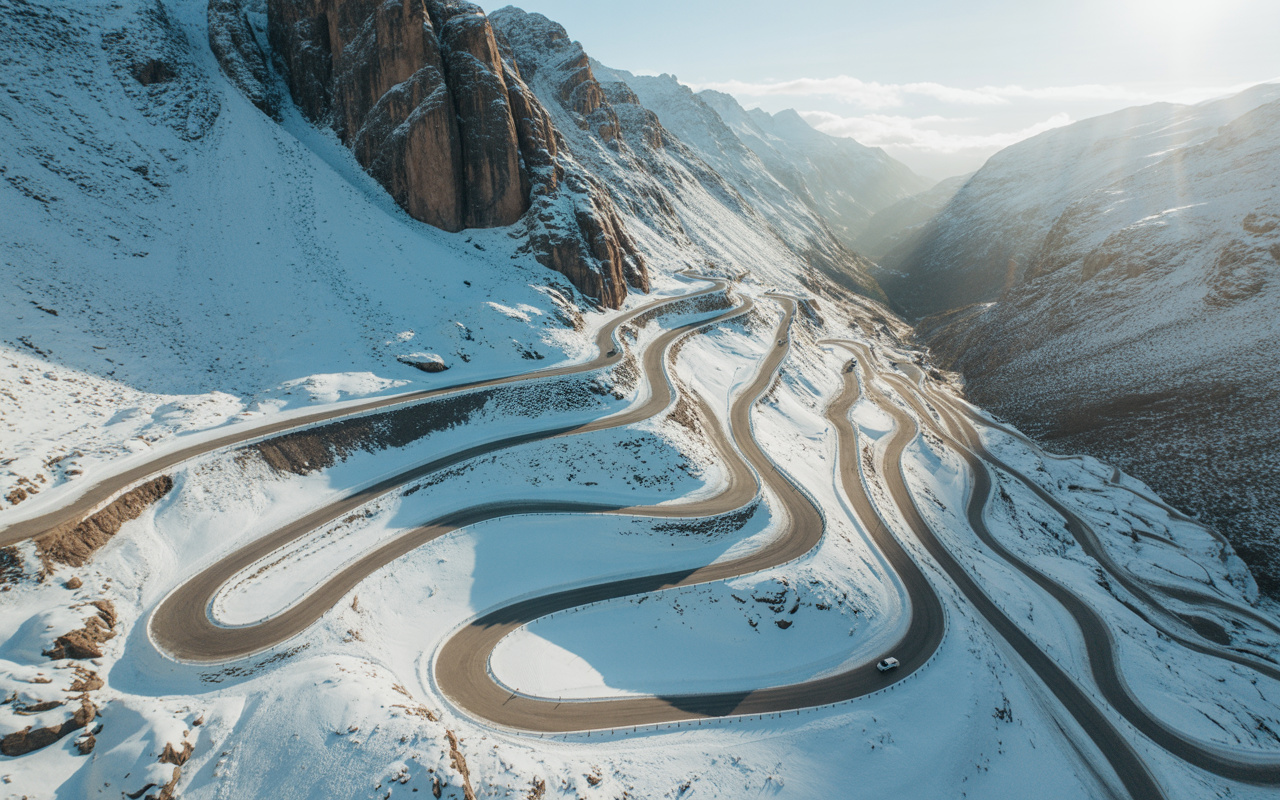


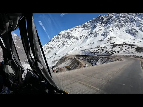
Road In The Andes Mountains Exceeds 3,200 Meters In Altitude, Crosses The Route Of Aconcagua, Faces Snow, Avalanches And Has Become One Of The Most Extreme Crossings In The Americas.
Between Chile and Argentina, there is a road that does not forgive mistakes. It climbs relentlessly through the Andes Mountains, accumulating hairpin turns over rock walls, crossing a region where oxygen thins above 3,200 meters in altitude, and leads directly to the surroundings of the highest mountain in the western hemisphere, Aconcagua, at 6,961 meters in altitude. In this range of the mountain range, the weather changes in a matter of minutes, snow can block the asphalt even outside of winter, and avalanches are a real risk.
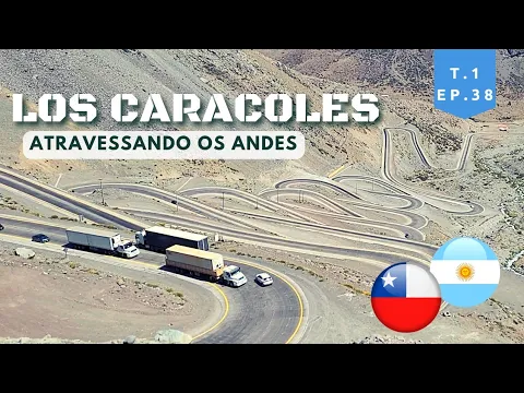
In the heart of this scenario operates Ruta Nacional 7, which on the international stretch connects to the Los Caracoles system, on the Chilean side, forming the main land link between the two countries. This corridor crosses the Cristo Redentor International Pass, one of the highest road points in the Americas, with stretches that reach 3,832 meters in altitude at the old pass and about 3,200 meters in the current tunnel.
This is not just a tourist road. It is one of the main logistical arteries of South America, through which multimillion-dollar cargoes, exports, refrigerated trucks, industrial products, and constant trade flows between the Pacific and the Atlantic circulate.
-
The Argentine government celebrates the lowest poverty rate in 7 years, but experts warn that the methodology has changed, real wages have fallen, unemployment has risen, and the number of people on the streets of Buenos Aires has increased by 57% since Milei took office.

-
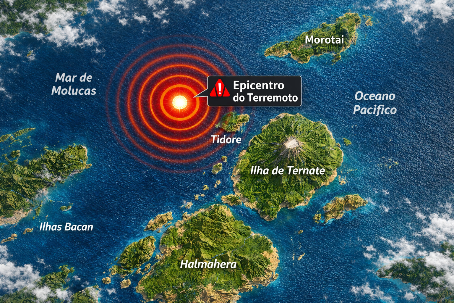
7.8 magnitude earthquake in Indonesia frightens the population, triggers tsunami alert, and hits an island with over 200,000 inhabitants this Thursday.
-
Google will finally let you change that embarrassing Gmail address you created in your teenage years without losing any accounts, logins, or old emails: the feature is already available in the United States.

-
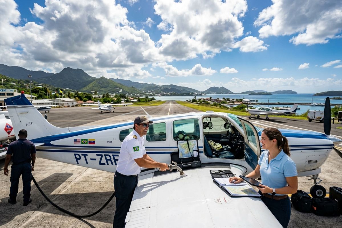
Heading to Brazil in a Bonanza F33 single-engine aircraft: a couple departs from Florida on a visual flight, makes technical stops in the Caribbean to refuel and organize paperwork, and begins the staged crossing until they reach the country.

The Crossing Over The Most Violent Natural Wall On The Continent
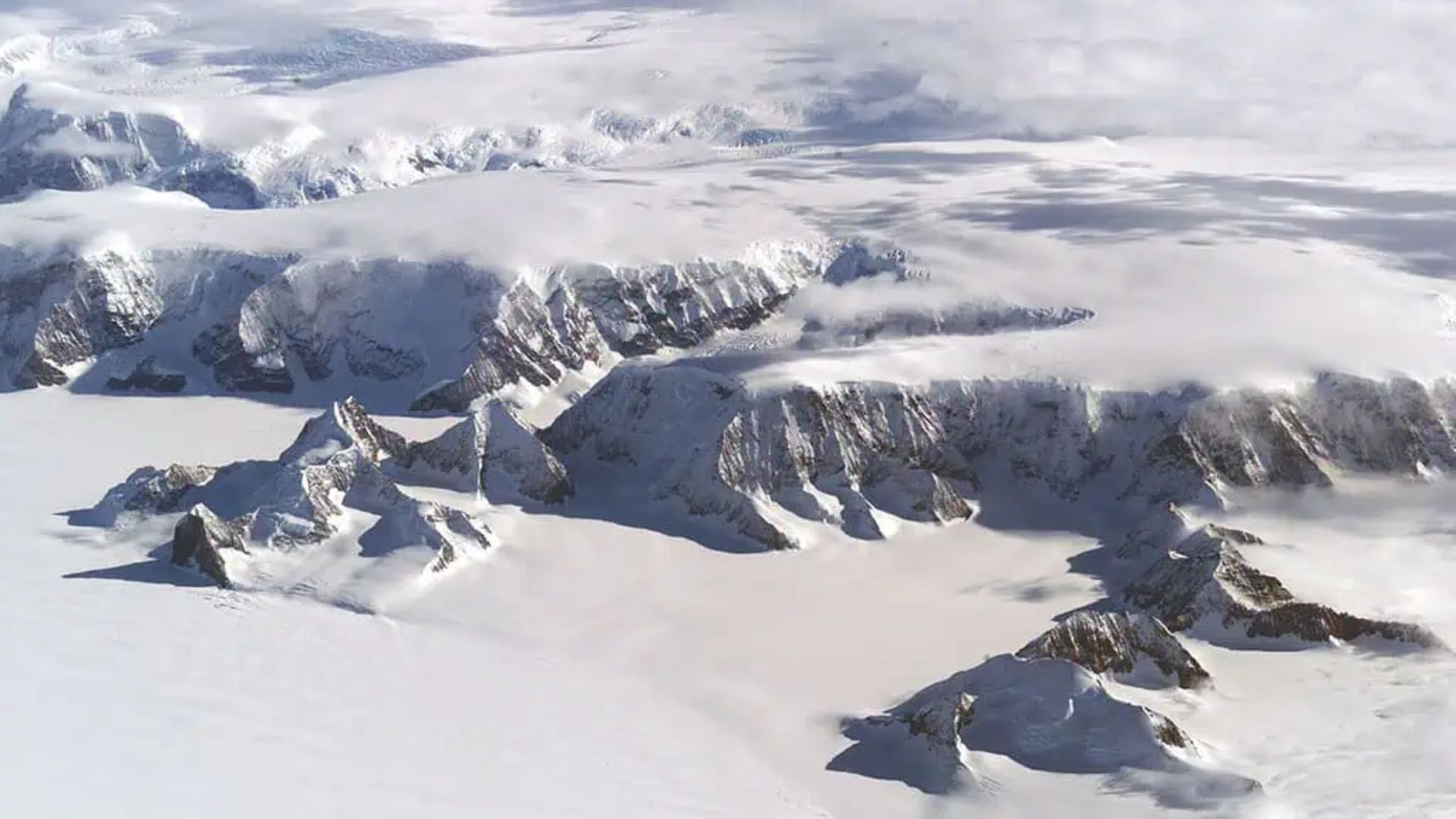
The Andes Mountains are not an ordinary mountain range. They are the geological backbone of South America, formed by violent tectonic shocks over millions of years. In this specific stretch between Chile and Argentina, the relief is abrupt, with extreme changes in elevation, vertical cliffs, and deep valleys where winds reach destructive speeds.
Building a highway in this environment required direct cuts into solid rock, stabilization of gigantic slopes, drainage systems for meltwater, and permanent stabilization works. Even so, nature remains sovereign. Every year, traffic is interrupted by intense snowstorms, avalanches, mudslides, and total freezing of the road.
During winter, road closures can last for weeks, isolating international traffic and causing direct impacts on trade between the two countries.
Altitude Above 3,200 Meters: When The Body, The Engine, And The Brakes Fail
Above 3,000 meters in altitude, the human body begins to suffer the effects of oxygen thinning. Drivers report dizziness, headaches, sudden fatigue, and reduced reflexes. In vehicles, especially those with naturally aspirated engines, there’s a real loss of power due to the lower air density.
The brakes operate under more severe conditions due to the long winding descents. A miscalculation, overheating, or mechanical failure leaves no room for correction: on the other side of the guardrail is the void.
In winter, this scenario is compounded by black ice, an invisible layer that turns asphalt into a skating rink. That’s why, during various times of the year, the crossing is only authorized with the use of chains on the tires.
The Curve System Known As “Los Caracoles” And The Design That Defies Gravity
The Chilean stretch of this highway is world-renowned for the curve system called “Los Caracoles”, a sequence of elbows so tight that seen from above, they resemble a spiral staircase embedded in the mountain. Each curve was designed to overcome brutal changes in elevation with minimal longitudinal slope.
From an engineering perspective, this is an extreme solution created because there was no physical space for gentler ramps. The result is a technical route, where the driver needs to constantly downshift, control torque, maintain stability, and operate the vehicle almost like on a mountain racing course.
When The Road Begins To Serve Aconcagua And International Extreme Tourism
Aconcagua, the highest mountain in the Americas, attracts professional climbers from all over the world, as well as tourists who simply wish to reach the viewpoints and the Provincial Park. All this movement occurs precisely because of the road axis that passes through the Cristo Redentor Pass.
This has caused the road to take on a dual function: international logistics route and high mountain tourism corridor. Hotels, refuges, support centers, altitude ambulances, and rescue teams are on permanent standby along the route.
During the peak season, thousands of people travel this stretch weekly, coming from North America, Europe, and Asia to try to reach the summit of Aconcagua.
The Economic Importance Of A Road That Connects Two Oceans
This road does not only serve tourism. It integrates the so-called Bioceanic Corridor, which connects the ports of Chile on the Pacific Ocean to the production centers of Argentina and, by extension, to the Atlantic. Trucks that cross this stretch daily transport:
Grains, meats, wines, industrial parts, ores, energy equipment, and chemical products. Any prolonged interruption of the highway generates immediate effects on prices, supply, and exports.
Therefore, traffic control is rigidly monitored by Chilean and Argentine authorities, with customs, meteorological, and security posts spread along the ascent.
Snow, Avalanches, And Total Closures Turn The Road Into A Permanent Risk
Unlike regular highways, this road is not predictable. Even in summer, snowstorms can occur abruptly in some higher-altitude areas. In winter, the risk of avalanches increases exponentially, necessitating preventive closures.
There are records of trucks being dragged by shifts in snow mass, entire lanes being buried, and blockages lasting more than 30 days in some critical years.
With each reopening, heavy machinery is used to remove snow with giant blades, while teams check for any rock displacement, base erosion, or compromising of tunnels.
When Driving Stops Being Transportation And Becomes An Absolute Technical Test
For ordinary drivers, this route demands respect. For truck drivers, it requires extreme planning. For motorcyclists, it is considered one of the most technical stretches in the Americas. Each curve demands instant reading of terrain, slope, wind, and grip.
There is no room for improvisation. The road demands mastery of the vehicle, physical preparedness, constant attention, and full understanding of the mountain environment.
The Road As A Living Border Between Engineering And Raw Nature
Few highways in the world make the ongoing duel between human engineering and natural forces as clear as this Andes crossing. Every centimeter of asphalt was conquered with explosives, concrete, steel, and calculations of resistance. And still, every year, the mountain exacts its price.
This road is not just a path between two countries. It is a living line drawn across one of the most hostile regions on the planet, where altitude, gravity, climate, and geology act against any human error.
When The Crossing Becomes As Valuable As The Destination
Today, crossing this stretch is not just a logistical necessity. It has become a life experience. Drivers seek the route for the challenge, climbers for access to Aconcagua, tourists for the viewpoints, and photographers for the ice-covered cliffs.
The road has ceased to be just asphalt. It has become a symbol of territorial overcoming, engineering in extreme environments, and a connection between two worlds separated by the most imposing mountain range in the Americas.


Subi e desci Los Caracoles no mesmo dia. Sensacional. Vale cada metro, cada curva, cada visual. É só respeitar e não “inventar” e ter ótima lembrança da experiência e assunto pra Vida toda.
Subi e desci Los Caracoles no mesmo dia. Sensacional. Vale cada metro, cada curva, cada visual. É só respeitar e não “inventar” e ter ótima lembrança e assunto pra Vida toda.
Percorri montanha acima e montanha abaixo no mesmo dia. Sensacional. Uma experiência que vale cada metro, cada curva e cada visual. É só respeitar, não “inventar” e será ótima lembrança e assunto pra Vida toda