 Portuguese
  English
  Spanish
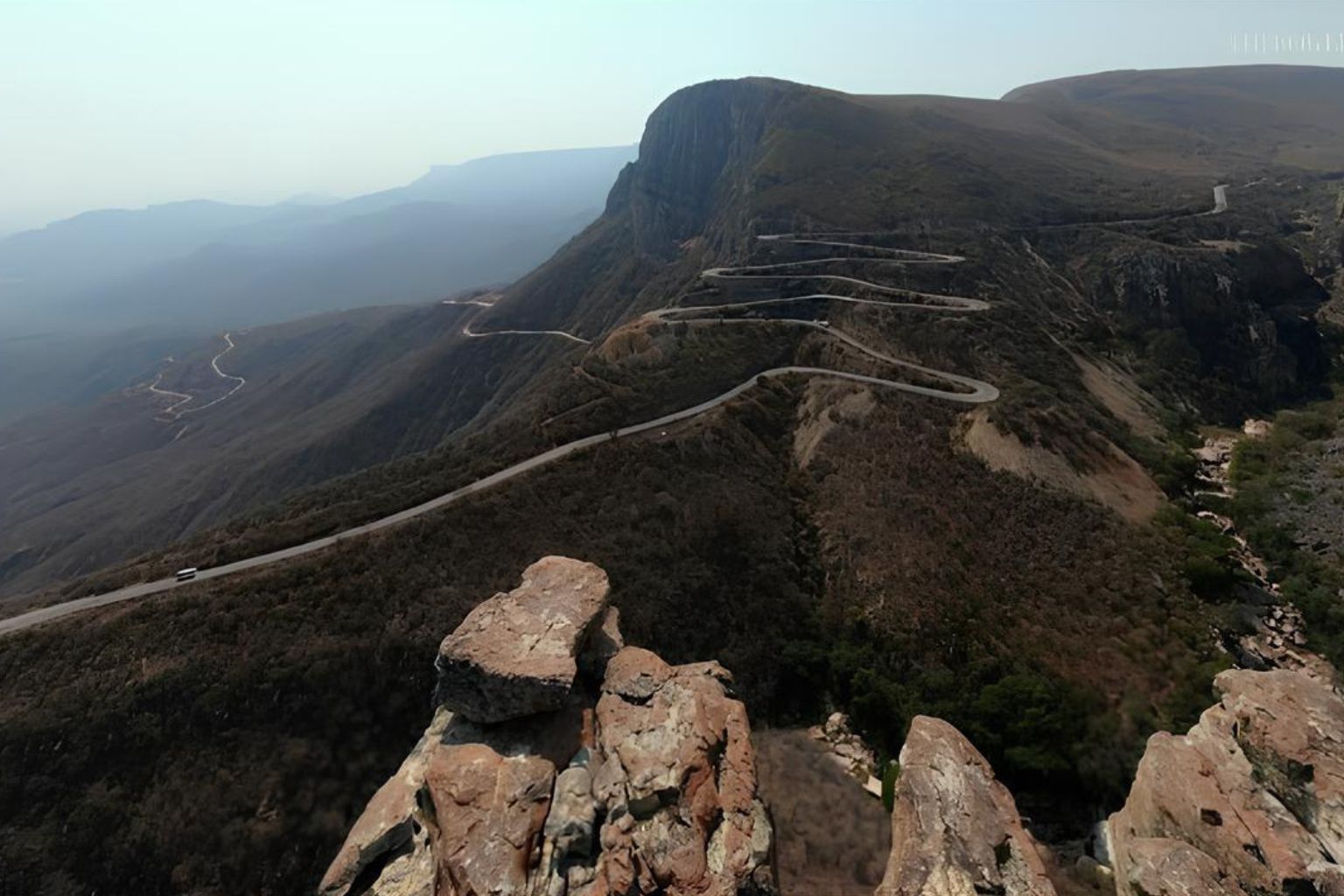
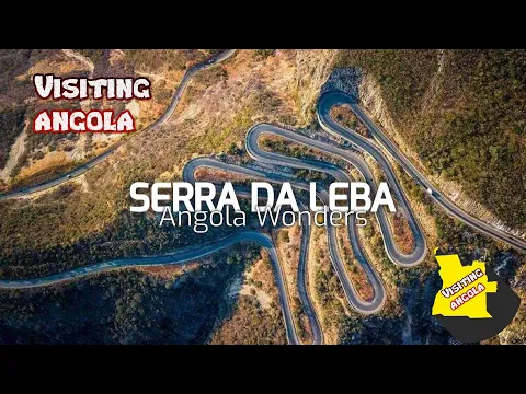
At 1,845 Meters Above Sea Level, The Serra da Leba Connects The Huíla Plateau To The Namibe Coast In Angola With Zigzag Curves That Have Become A Global Symbol Of Engineering And African Landscape.
The Serra da Leba is not just a mountain road — it is one of the most recognizable images of Angola and one of the most impressive roadway designs in Southern Africa. Located in the Namibe province, the route reaches about 1,845 Meters Above Sea Level and connects the central plateau of Angola to the coastal plain that flows into the Atlantic Ocean. Viewed from above, the road forms an almost geometric sequence of zigzag curves that appear to be drawn with a ruler on the mountainside. This sinuous pattern has turned the stretch into a national postcard and an international reference when it comes to scenic roads.
The Strategic Role Of The Serra da Leba
The road is part of the national highway EN280, linking Lubango, in the Huíla plateau, to the coastal city of Moçâmedes, the capital of Namibe province. Historically, this connection has been essential for transporting goods between the agricultural interior and the Atlantic coast.
Before the construction of the modern road, crossing the mountain was extremely difficult. The abrupt height difference between the plateau and the plain made transportation slow and risky. The solution found was a design that reduces the average slope through multiple tight curves.
-
Friends have been building a small “town” for 30 years to grow old together, with compact houses, a common area, nature surrounding it, and a collective life project designed for friendship, coexistence, and simplicity.

-
This small town in Germany created its own currency 24 years ago, today it circulates millions per year, is accepted in over 300 stores, and the German government allowed all of this to happen under one condition.

-
Curitiba is shrinking and is expected to lose 97,000 residents by 2050, while inland cities in Paraná such as Sarandi, Araucária, and Toledo are experiencing accelerated growth that is changing the entire state’s map.

-
Tourists were poisoned on Everest in a million-dollar fraud scheme involving helicopters that diverted over $19 million and shocked international authorities.

The road was built in the late 1960s, during the Portuguese colonial period, as part of a plan for territorial integration and logistical strengthening of southern Angola.
Engineering To Overcome The Gradient On The Angolan Road
The main technical challenge of the Serra da Leba has always been the steep gradient between the top of the escarpment and the base of the mountain. Instead of opting for extensive tunnels or aggressive vertical cuts into the rock, engineers adopted the technique of “switchbacks” — successive curves that allow gradual descents.
Each curve reduces the slope, distributing the descent over several kilometers. This technical solution:
- Reduces engine strain in heavy vehicles
- Minimizes the risk of brake overheating
- Increases safety on long descents
The result was a layout that fits the mountain like an asphalt snake, maintaining structural stability and integrating with the natural terrain.
Geology And Formation Of The Escarpment
The Serra da Leba is part of a mountain range associated with the ancient geological formations of southern Angola. The region features steep cliffs, metamorphic rocks, and structures formed over millions of years.
The contrast between the elevated plateau and the coastal plain occurs due to tectonic movements and differential erosion. The road crosses these rock formations, exposing geological layers that also spark academic interest.
The change in altitude causes variations in climate and vegetation: cooler temperatures at the top; a drier and hotter environment at the base.
The Lookout That Reveals The Perfect Design Of The Road At 1,845 Meters Above Sea Level
One of the most visited spots is the lookout of the Serra da Leba. From there, it is possible to observe the complete sequence of overlapping curves on the slope.
The aerial view is what established the road’s international fame. Photographs taken with drones or captured from the mountain’s peak show the almost symmetrical layout, creating a visual composition that resembles an architectural design applied to the mountain.
This image has circulated widely on social media, travel magazines, and tourist publications, helping to establish the Serra da Leba as a symbol of Angola.
From The Plateau To The Atlantic: Landscape Transition
As you begin the descent from 1,845 meters, travelers notice a gradual transformation of the scenery:
- High-altitude vegetation at the top
- Rocky slopes along the curves
- Progressive reduction of humidity
- Arrival at the coastal plain
The final destination is the Moçâmedes region, close to the Atlantic Ocean coast, where the landscape begins to be marked by drier climates and desert areas.
This transition over a few kilometers reinforces the visual impact of the journey.
Current Use And Economic Relevance

Despite its tourist fame, the road remains functional and active. Trucks and cargo vehicles use the route to transport products between the interior and the Namibe port.
The road connection contributes to:
- Agricultural output
- Transportation of industrial goods
- Regional mobility
Constant maintenance is necessary due to natural wear caused by thermal variations and heavy traffic.
Safety And Traffic Conditions
The route demands attention, especially for drivers facing the descent for the first time. The curves are tight and the continuous slope requires speed control.
In rainy or foggy conditions, visibility may be reduced. Still, the layout is considered stable and safe when driving limits are observed.
The Road That Became A National Symbol
The image of the Serra da Leba is often used in promotional tourism campaigns and institutional materials of Angola. The layout has come to represent:
- Integration Between Infrastructure And Nature
- Technical Achievement In Challenging Terrain
- Unique Geographical Beauty
For many Angolans, the road symbolizes a connection between the interior and the sea.
Winding roads exist in various mountainous regions around the world. However, the combination of altitude, almost symmetrical design, and environmental contrast gives the Serra da Leba its unique identity.
The geometric pattern of the curves, especially when viewed from above, is the element that differentiates this stretch and propels it internationally.
At 1,845 meters above sea level, the Serra da Leba represents a meeting point between engineering and geography in southern Angola. Built to overcome a steep gradient between the plateau and the coast, the road has become a national icon and a global reference among scenic routes.
Its zigzag layout, carved into the rock of Namibe province, not only fulfills a strategic logistical function but has also established itself as one of the most striking images of Angolan territory.


Seja o primeiro a reagir!