 Portuguese
  English
  Spanish
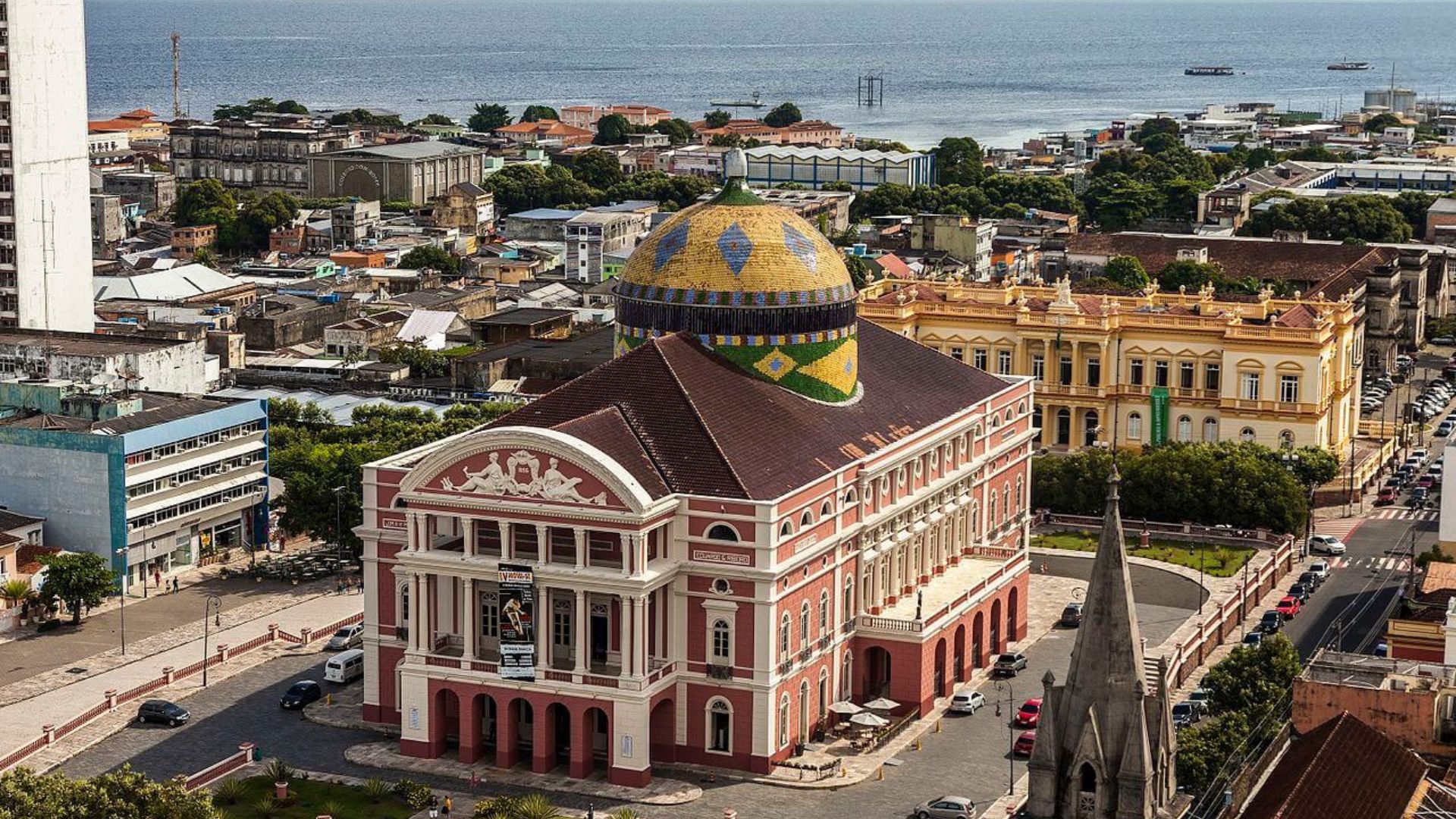
Amazon Metropolis Grows Between Rivers and Industry, Consolidates Strategic Role in the North and Expands International Prominence Even Far from the Country’s Main Highway Axes.
Manaus, the capital of Amazonas, has 2,063,689 inhabitants according to the 2022 Census and ranks as the 7th most populous city in Brazil, sustaining an economy anchored in the Free Trade Zone Industrial Pole and a logistics shaped by rivers, aviation, and long distances in the Amazon interior.
Located in the heart of the Amazon Rainforest, the city expanded around the Negro River and a network of igarapés, and has solidified a regional role as the main urban hub in the North, concentrating services, commerce, industry, and public institutions in an area of 11,400 square kilometers.
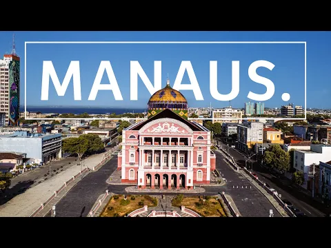
Throughout the 19th century, the Rubber Boom put Manaus on the map of international trade and funded works that still define its landscape, such as the Amazônia Theatre, inaugurated in 1896, a symbol of the period when the capital was nicknamed the “Paris of the Tropics.”
-
Friends have been building a small “town” for 30 years to grow old together, with compact houses, a common area, nature surrounding it, and a collective life project designed for friendship, coexistence, and simplicity.

-
This small town in Germany created its own currency 24 years ago, today it circulates millions per year, is accepted in over 300 stores, and the German government allowed all of this to happen under one condition.

-
Curitiba is shrinking and is expected to lose 97,000 residents by 2050, while inland cities in Paraná such as Sarandi, Araucária, and Toledo are experiencing accelerated growth that is changing the entire state’s map.

-
Tourists were poisoned on Everest in a million-dollar fraud scheme involving helicopters that diverted over $19 million and shocked international authorities.


Geographical Isolation and Challenges of BR-319
Although BR-319 exists as a planned link with Porto Velho, the so-called “middle section” remains the most fragile point of the corridor, with extensive segments unpaved, which makes the land connection irregular and, in practice, unreliable for routine travel.

This condition has pushed Manaus into a model of supply and circulation that depends on river and air transport, with cargo and passengers arriving by rivers and the Eduardo Gomes International Airport, while the distance from major centers in the Southeast and Midwest raises the costs of logistics chain stages.
Free Trade Zone of Manaus and Strength of the Industrial Pole
The contemporary boost came with the Free Trade Zone of Manaus, which transformed the capital into a national industrial hub, producing electronics, two-wheeled vehicles, and consumer goods, in addition to creating jobs and revenue that reconfigured the local labor market.
Official data from Suframa indicates that the Industrial Pole of Manaus had revenue of R$ 205.07 billion in 2024, a figure that helps explain why the metropolis maintains an urban growth pace even far from the consolidated highway routes of the Center-South.
Manaus as Host of G20 Events
In 2024, Manaus entered the route of international diplomacy by hosting meetings related to Brazil’s presidency of the G20, including agendas and parallel events focused on the Amazon and tropical forests, with participation from delegations and authorities in scheduled meetings in the city.
In addition to the symbolism, the holding of the group’s activities in the North highlighted the contrast between the economic weight of Manaus and its infrastructure bottlenecks, showing how a capital with a scaled industry coexists with transportation, sanitation, and housing pressure challenges.
Everyday Life Between Rivers, Heat, and Amazon Metropolis
In day-to-day life, the urban rhythm coexists with a riverside dynamic that remains essential, as rivers serve as pathways for communities, neighboring municipalities, and leisure, and also as a cultural reference, appearing in weekend leisure activities and city meeting points.
The cuisine reinforces this identity by giving prominence to fish such as tambaqui and regional ingredients, while the constant presence of the equatorial climate, with high humidity and elevated temperatures, shapes schedules, movements, and the use of open spaces throughout the year.
Tourism in Manaus: History of Rubber and Biodiversity
Visitors often quickly perceive the local duality when walking through historical areas and, in a short time, reach experiences linked to the forest and rivers, such as the Meeting of the Waters, where the Negro River and Solimões run side by side without mixing for kilometers.
In the center, the Adolpho Lisboa Municipal Market concentrates commerce and typical products in a historic building, while cultural facilities such as the Provincial Palace house collections and memories of the city, offering a portrait of how Manaus was formed through economic cycles and migrations.
The Museum of the Amazon, featuring an observation tower above the tree canopy, serves as a gateway to learn about species and scientific research, while urban spaces like the Ponta Negra waterfront act as a postcard along the Negro River.
The Arena da Amazônia, a legacy of the 2014 World Cup, reinforces how the city alternates global agendas and regional everyday life, adding to a circuit that mixes monuments from the rubber era, preservation areas, and the practical life of an Amazon metropolis.
Higher Education and Research in the Amazon Capital
In education, the presence of institutions such as the Federal University of Amazonas and the State University of Amazonas supports the training of professionals and scientific production, with research addressing strategic themes of the region, including biodiversity, health, and technological development.
This academic environment, combined with the industrial market, helps retain students and workers, fueling a demographic dynamic that concentrates population and services in the capital, whose population density reaches 181.01 inhabitants per square kilometer.
Climate, Best Time, and How to Get to Manaus
In climatic terms, the city alternates between wetter periods and months with reduced rainfall, which influences riverboat trips, trails, and daily routines, as the flooding and ebbing of the rivers determine access to freshwater beaches and igapó landscapes.
To get there, the main entry point is the airport, with regular flights to major capitals, while access by boats remains relevant for passengers and cargo, and urban transport occurs via buses, taxis, and apps, with boats used on specific routes and crossings.


-

-

-

-

8 pessoas reagiram a isso.