 Portuguese
  English
  Spanish
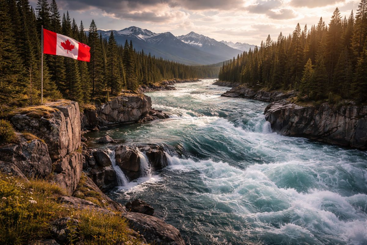
The Most Voluminous River In Canada, The Mackenzie Route Begins At Great Slave Lake And Flows Into The Arctic Ocean, With An Average Flow Of Over 10000 M³ Per Second; Nevertheless, Thawing Permafrost, Indigenous Opposition, And Seasonal Logistics Undermine Many Energy And Transport Promises Repeated For Decades.
The most voluminous river in Canada, known to many as the Mackenzie River, has returned to the center of the debate about infrastructure in the north of the country because it brings together, in a single map line, water on a continental scale, mineral resources, and a natural outlet to the Arctic.
However, the same grandeur that seduces also imposes limits. What seems like an inevitable corridor on paper becomes a survival test when the work meets permafrost, distance, and environmental costs, and the story of the Mackenzie accumulates projects that start with ambition and end in setbacks.
Where The Strength Of The Mackenzie Comes From And Why It Complicates Everything

The journey begins at Great Slave Lake, described as the deepest lake in North America, with depths exceeding 600 m.
-
Friends have been building a small “town” for 30 years to grow old together, with compact houses, a common area, nature surrounding it, and a collective life project designed for friendship, coexistence, and simplicity.

-
This small town in Germany created its own currency 24 years ago, today it circulates millions per year, is accepted in over 300 stores, and the German government allowed all of this to happen under one condition.

-
Curitiba is shrinking and is expected to lose 97,000 residents by 2050, while inland cities in Paraná such as Sarandi, Araucária, and Toledo are experiencing accelerated growth that is changing the entire state’s map.

-
Tourists were poisoned on Everest in a million-dollar fraud scheme involving helicopters that diverted over $19 million and shocked international authorities.


From there, the river organizes itself and flows northward, crossing different ecological zones until it empties into the Arctic Ocean, carrying sediments and nutrients through a territory that, in many stretches, remains remote.
This scale is measurable. The Mackenzie extends over 4,200 km and drains a basin of almost 1.8 million km², with an average flow of over 10000 m³ per second, numbers that place it among the rivers with the highest flow in the northern hemisphere.
When a natural system operates on this scale, any human intervention becomes an automatically high-risk intervention.
The Energy And Transport Corridor That Never Fully Delivers

The idea of transforming the most voluminous river in Canada into a logistical axis does not come from nowhere.
During part of the 20th century, when roads and railways were seen as almost impossible on frozen terrain, the Mackenzie was, out of necessity, the natural transportation route for a vast region poorly connected to industrial centers.
Over time, the “Mackenzie Corridor” began to be promoted as a platform for energy and strategic resources.
The argument is simple: if the river connects resource-rich areas to the Arctic and the interior, it could support oil pipelines, gas pipelines, terminals, and supply chains.
The problem is that the real cost is not just in steel and concrete; it’s in the timeline and the land.
Oil, Diamonds, And The Impulse That Pulls Projects North
Talking about the Mackenzie without mentioning the Athabasca tar sands is to ignore a central engine.
This material is described as one of the largest estimated reserves in the world, with over 1.7 trillion barrels beneath the surface.
However, extraction is difficult: it is a dense mixture that requires enormous amounts of water and energy to separate oil, sand, and impurities.
The Mackenzie basin appears, in this context, as both a resource and a route. Water is seen as a critical component for industrial processes, but every cubic meter extracted pressures fragile boreal ecosystems.
In parallel, the region also hosts diamond mines, such as Ekati and Diavik, whose logistics depend on seasonal windows: in winter, temporary ice roads; in summer, river transport.
Wealth exists, but access to it is a puzzle with melting pieces.
Permafrost And Methane: The Environmental Cost That Alters The Budget
The biggest physical barrier is permafrost. There are records that describe this territory as a carbon vault, with billions of tons stored in biomass and sediments.
When works disturb this frozen ground, thawing accelerates and the system releases methane, a greenhouse gas much more potent than carbon dioxide in the short term.
The consequence is twofold. On one hand, soil instability increases the risk of failures in foundations and pipelines, raising costs and delays.
On the other hand, projects designed to extract or transport energy may trigger climate feedback cycles, amplifying impacts beyond the perimeter of the enterprise.
This is why, in the most voluminous river in Canada, engineering competes not only with geography; it competes with the physics of climate.
Seasonal Logistics And Isolation: When The Road Disappears, Risk Remains
Even when there is money and interest, seasonal logistics limit the pace.
In northern Canada, routes appear and disappear depending on the season, and this changes the construction economy: heavy equipment, fuel, and supplies need to fit into a short time frame, under extreme weather.
This dependency creates operational vulnerability. In winter, ice can enable what summer prevents; in summer, the river returns as a route, but with its own risks.
Seasonal logistics is not a detail; it is the control system for the entire region, and any plan that ignores this tends to repeat the pattern of delays, reassessments, and cancellations.
Indigenous Communities And Caribou: Social Limits That Are Also Infrastructure
Around Great Slave Lake, Indigenous Dene communities are cited, connected to fish, caribou, and seasonal migration routes.
For these populations, the lake and the river are not just the beginning and end of a navigation route but a complete ecosystem and a living space.
The caribou is a central piece because its migrations depend on continuous biological corridors.
New roads, pipeline crossings, and industrial installations can fragment routes and accelerate population declines.
When the work cuts the caribou corridor, it is not just wildlife in crisis; it is a way of life. This conflict can’t be resolved merely with spreadsheets; it requires governance, consultation, and clear limits.
The Lesson Of Canol And The Ghost Of The Project That Stayed Behind
History records a decisive test during World War II when the Canol Project turned the Mackenzie into the backbone of an infrastructure effort to bring fuel to U.S. armed forces, with oil pipelines and pumping stations built under pressure.
However, the outcome is described as bitter: costs exceeded benefits, operational efficiency was low, and the system functioned for a short time before being abandoned, leaving industrial waste and stretches of infrastructure scattered throughout the north.
The lesson is harsh: it is possible to build quickly, but not always possible to sustain it. Afterwards, proposals for gas pipelines and the so-called Mackenzie Gas Project also got stuck amid market issues, opposition, environmental concerns, and rising costs.
The Arctic Opening Routes And Closing The Margin For Error
Today, with thawing advancing, the Arctic gains commercial and geopolitical relevance.
The possibility of new navigation routes shortens distances and reopens the debate about connecting the interior of North America to the Arctic Ocean, placing the most voluminous river in Canada once again at the center of the map.
However, the opening comes with clear risks: more vessels increase the chances of spills, noise, and impacts on fragile coastal ecosystems.
The Arctic may enhance connectivity, but it also reduces the margin for error, because any accident has less capacity for response and more recovery time.
What Remains When The Big Project Does Not Happen
The Mackenzie is not just a watercourse; it is a practical limit to industrial ambition.
With each cycle, the promise of a corridor reappears with new names and new financing models, but it runs into permafrost, seasonal logistics, environmental pressure, and social conflicts.
In other words, the bottleneck is not a lack of resources; it is the sum of restrictions.
The most voluminous river in Canada concentrates, in a single corridor, opportunity and fragility, and this forces any plan to treat environmental risk, social acceptance, and logistical cost as part of the project, not as a footnote.
When looking at Great Slave Lake, at thawing permafrost, and at the rapidly changing Arctic, the Mackenzie appears less as a ready route and more as a thermostat.
It measures how far Canada is willing to advance in infrastructure without turning the north into a long-term climate and social liability.
Now I’m interested in knowing your personal take. Do you think the country should insist on large works on the most voluminous river in Canada even with seasonal logistics and methane risk, or should the priority be to limit interventions and protect caribou corridors? If you lived in the region, what would you require to support a project of this magnitude?


-

-

-

-

6 pessoas reagiram a isso.