 Portuguese
  English
  Spanish
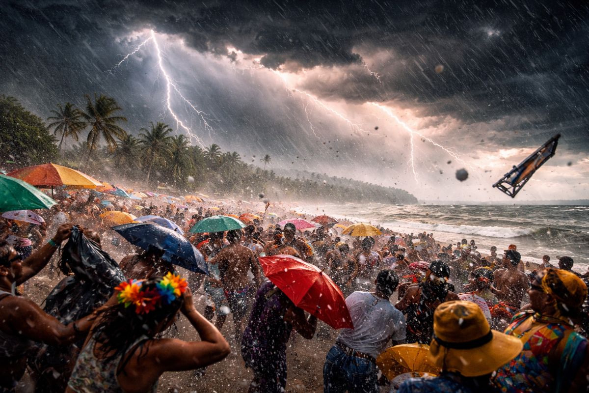
Between 2pm Saturday and 10pm Sunday, the Civil Defense projects instability in all regions of SC, with high risk in the orange areas and moderate risk in the sections under observation, under a typical summer standard marked by heat, high humidity, and atmospheric disturbances in several vertical layers.
SC opens the Carnival period under a weather warning for severe storms between Saturday afternoon (14) and Sunday night (15). The combination of locally intense rain, possibility of hail, and isolated gusts of wind places the state in a scenario of increased attention for rapid impacts.
According to information from the NDMAIS portal, the alert was issued by the state Civil Defense and covers all regions of Santa Catarina, with different levels of risk according to the map. The critical window of 32 hours concentrates conditions for localized but potentially severe occurrences, especially where the soil has already received significant rain the day before.
Alert Window in SC: Duration, Rhythm and Behavior of the Event

The period between 2pm Saturday and 10pm Sunday does not indicate continuous rain the entire time, but rather an interval in which instabilities can organize more forcefully in specific points. In such episodes, the biggest issue tends to be the rapidity of the change, with the sky closing in a short time, heavy showers, and sudden winds.
-
Motorola launched the Signature with a gold seal from DxOMark, tying with the iPhone 17 Pro in camera performance, Snapdragon 8 Gen 5 that surpassed 3 million in benchmarks, and a zoom that impresses even at night.

-
Satellites reveal beneath the Sahara a giant river buried for thousands of kilometers: study shows that the largest hot desert on the planet was once traversed by a river system comparable to the largest on Earth.

-
Scientists have captured something never seen in space: newly born stars are creating gigantic rings of light a thousand times larger than the distance between the Earth and the Sun, and this changes everything we knew about stellar birth.

-
Geologists find traces of a continent that disappeared 155 million years ago after separating from Australia and reveal that it did not sink, but broke into fragments scattered across Southeast Asia.

In practice, this pattern requires local risk: neighboring neighborhoods may face different conditions at the same time.
In SC, the forecast points to isolated storms, typical of summer, but with the potential to concentrate a large amount of precipitation in a short interval.
This type of concentration is what most pressures urban drainage, slopes, and movements in vulnerable areas.
Where the Risk is High and Where it Remains Moderate on the Civil Defense Map
The areas classified as attention (orange), with high risk for flooding and flash floods, include part of the Meio-Oeste, part of the Planalto Sul, and the Litoral Sul, as well as all of the Planalto Norte, Médio and Alto Vale do Itajaí, Grande Florianópolis, Litoral Norte, and Baixo Vale do Itajaí.
In these sectors, the frequency and intensity of instabilities tend to be greater throughout the warning period.
In observation (yellow), with moderate risk, appear the Grande Oeste, part of the Meio-Oeste, part of the Planalto Sul, and part of the Litoral Sul. This division shows that the risk in SC is not homogeneous: it changes by sub-region and can fluctuate depending on the evolution of clouds and rain. Therefore, the geographical reference of the map needs to be read alongside real-time updates.
Why Severe Storms Gain Strength This Carnival in SC
The central meteorological explanation involves three factors working together: heat, high humidity, and disturbances at different atmospheric levels.
When this trio combines, the warm, humid air rises more efficiently, favoring clouds of large vertical development. This process increases the chance of intense showers and more aggressive convective episodes.
Even with isolated distribution, the atmosphere can produce high-energy events in a short period. It is in this context that sudden windstorms and hail arise. In SC, the risk for these occurrences has been indicated as moderate in all regions, which reinforces an important technical point: it is not necessary for instability to be widespread to generate relevant impact.
Intense Rain, Hail, Windstorms, and Landslides: The Main Expected Effects
With rain concentrated over a short time, the first effect tends to appear in the drainage system, with flooding and rapid flash floods.
Roads with a history of water accumulation, urban lowlands, and sections near watercourses become more sensitive. The perception of “passing rain” can be misleading when the volume falls with great intensity in minutes.
In the case of landslides, the alert gains additional weight because there is a sequence of rainy days and areas with high volumes recorded previously. This increases soil saturation, especially in regions highlighted in orange. When the ground is already soaked, the margin of safety decreases, and any new intense shower can accelerate instability processes on slopes.
Safety Recommendations to Navigate the Critical Period in SC
During severe storms, the recommendation is to seek shelter in a safe location, away from windows and objects that may be thrown by the wind. In situations of strong gusts, it is also important to avoid staying close to susceptible structures, such as signs, walls, and external elements without proper fixation. A quick response in the first minutes of the event usually significantly reduces personal risk.
Another central measure is not to cross flooded streets, bridges, or submerged walkways during flash floods. The water level can hide currents, unevenness, and pavement damage. In SC, where the alert predicts isolated episodes with high potential in some areas, the decision to halt movement at the right moment can prevent serious accidents.
The scenario for Carnival in SC combines a broad alert, regionally unequal risk, and the possibility of intense events in a short period.
The key point is not just “if it will rain,” but how, where, and with what intensity the instability will organize between Saturday and Sunday.
In your region of SC, what situation tends to concern you the most during severe storms: flooding on a specific street, flash floods near a bridge, hail, or strong gusts near trees and poles? And what practical measure do you take first to protect yourself?


-

-

-

-

-

-

372 pessoas reagiram a isso.