 Portuguese
  English
  Spanish
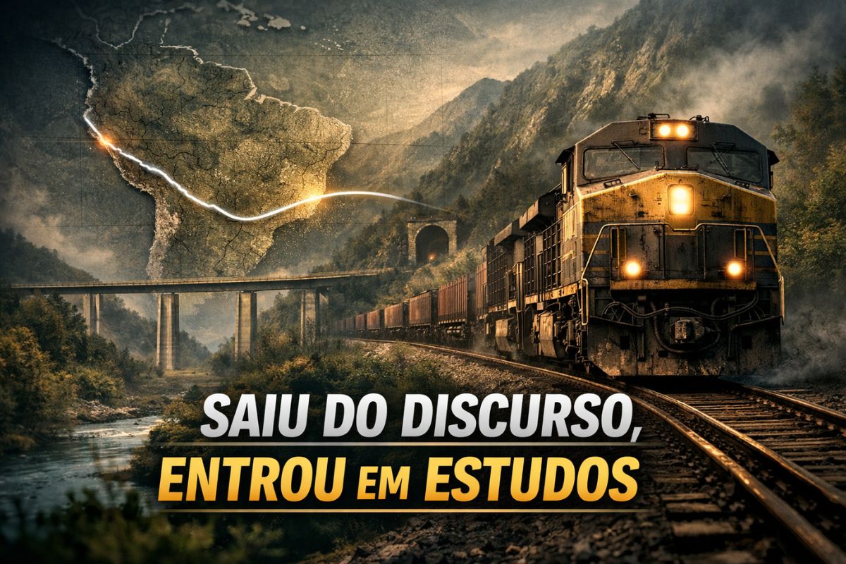


Planned By Brazil, China And Peru, The Insane Bioceanic Railway Of 4,500 Km Would Link Fiol, North South And Grain Corridors From The Midwest To The Andes And To A Chinese Port On The Pacific, Shortening Days Of Travel To Asia With Feasibility Studies In 2025 And No Works Started Yet
In December 2024, when the channel Construction Time detailed for the first time the layout of the so-called Brazil Peru bioceanic railway, the project still sounded like a distant line drawn on the map. Since then, the insane bioceanic railway of 4,500 km has entered a more technical phase, with Brazil, China, and Peru aligning feasibility studies and cost scenarios throughout 2025, still without construction sites opened in Brazilian territory.
At the beginning of 2025, the corridor moved from generic discourse to a formal program of studies with a memorandum of understanding signed between the Brazilian government, Chinese railway planning institutions, and Peruvian representatives. The focus is to measure, with numbers and maps on the table, whether a continuous railway linking the Atlantic in Bahia to the port of Shankai on the Pacific makes economic, environmental, and technical sense before any tracks are ordered.
From Steel Wire On The Map To The Corridor That Crosses Two Oceans

The central image of the project is that of a steel wire crossing South America. This wire begins in the region of Ilhéus, Bahia, where the Fiol West East Integration Railway connects to the future deep-water port on the Atlantic.
-
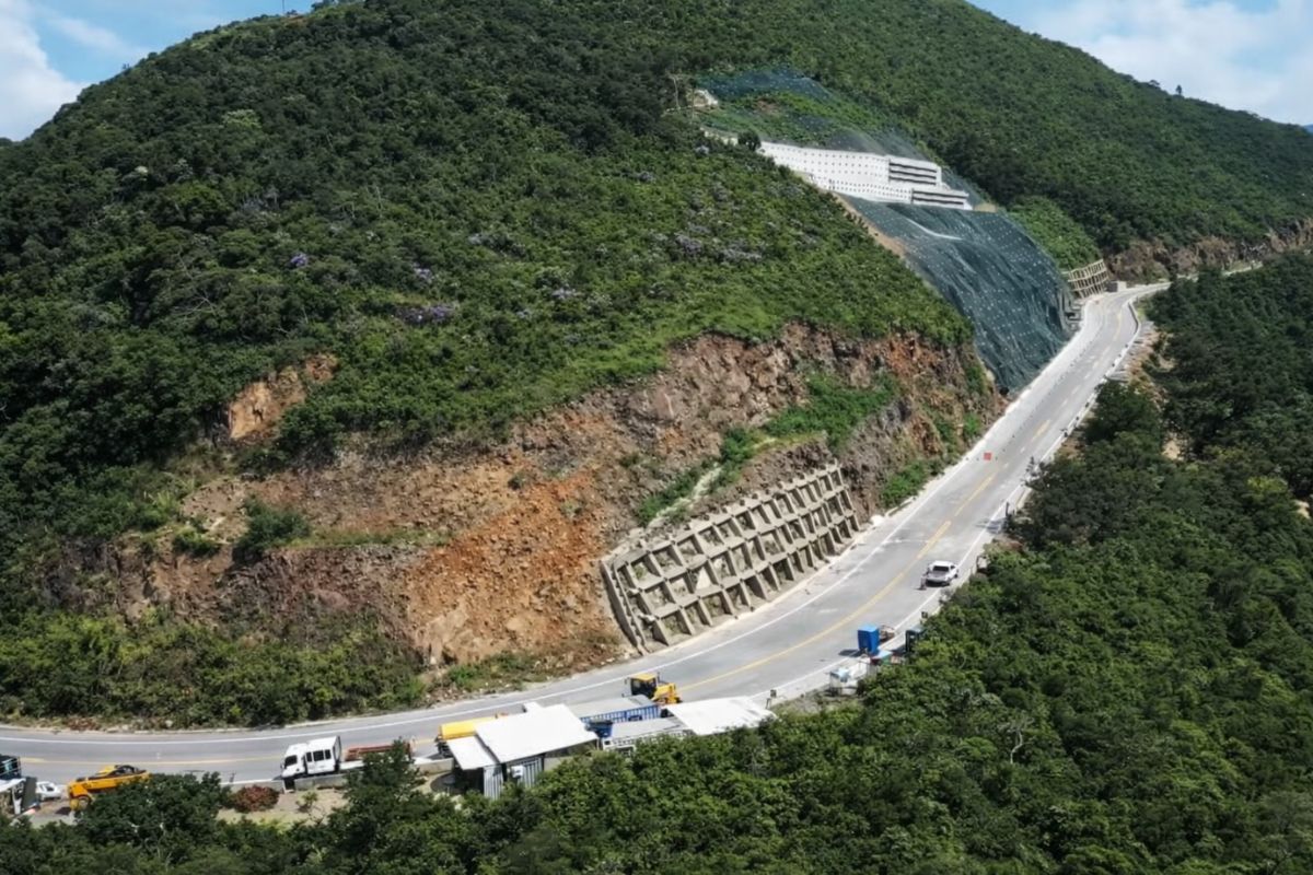
The section of Serra da Rocinha on BR-285 is now open in Timbé do Sul: 50 m tensioned curtains and top-down technique stabilize the slope, with a stairway duct controlling the water.
-
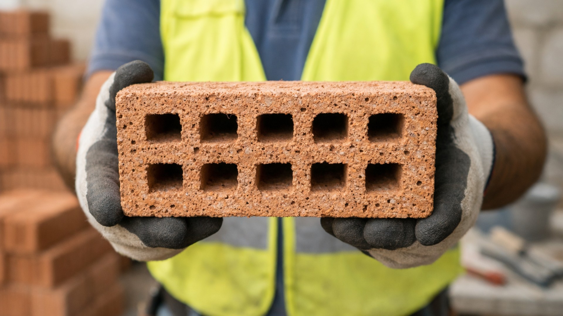
Scientists use sawdust mixed with clay to create a lighter brick, promising efficient thermal insulation and impressing by transforming waste into a solution for construction.
-
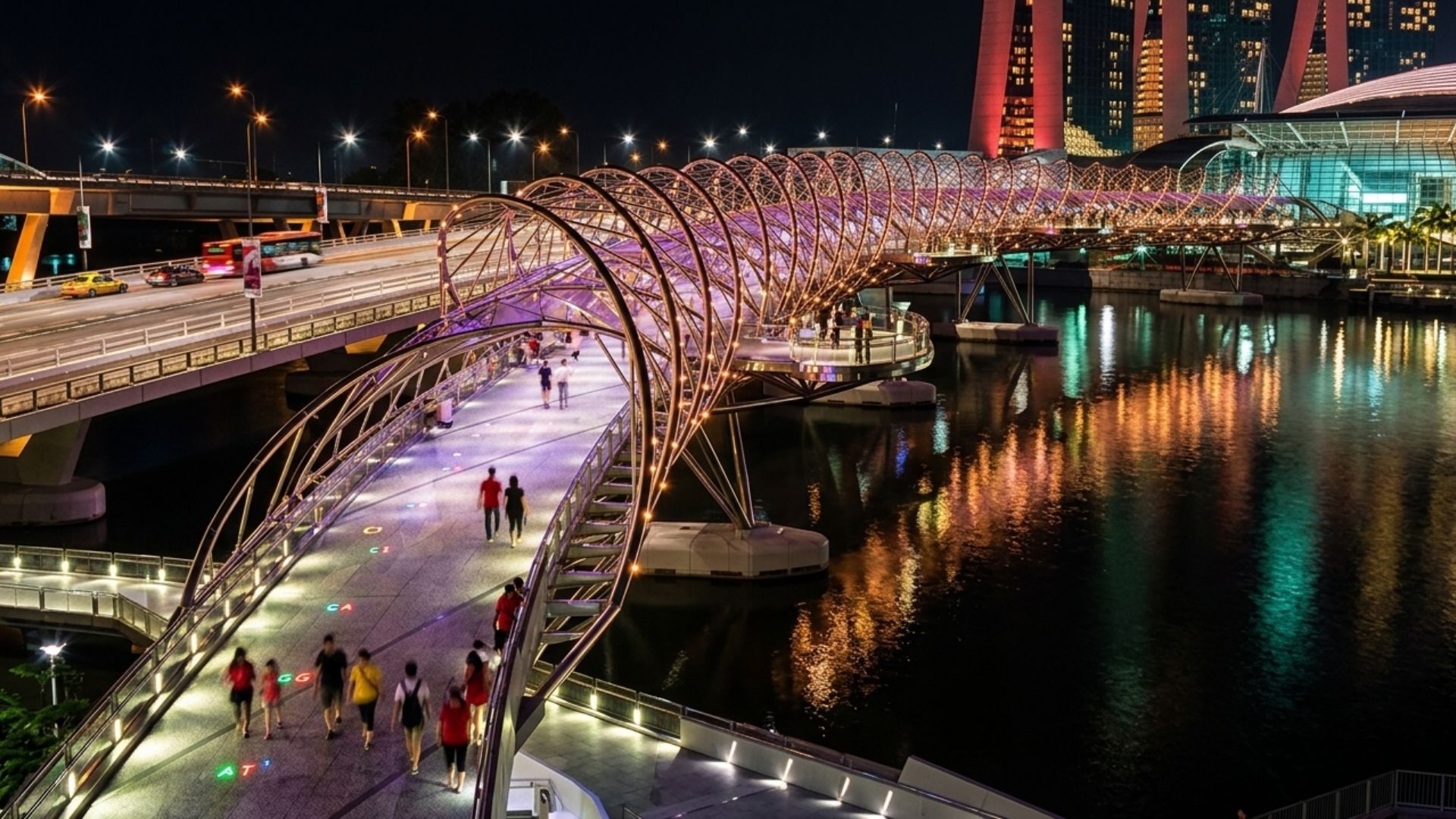
With a DNA shape, this bridge in Singapore draws attention in modern architecture and surprises tourists by transforming a simple crossing into an unforgettable visual experience in the urban heart.
-
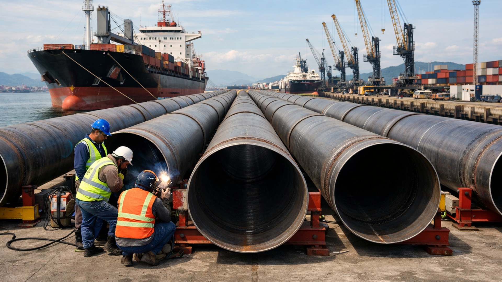
Giant underwater pipeline begins to take shape with a R$ 134.7 million project at the Port of Santos: the 1.7 km structure uses 12-meter and 700 mm pipes to supply water to 450,000 people in Guarujá.

From there, the preliminary layout of the insane bioceanic railway of 4,500 km advances through western Bahia, crosses the Cerrado in Goiás, and meets the North South Railway, the longitudinal axis of the Brazilian network.
From the connection with North South, the corridor proceeds towards the agricultural heart of Mato Grosso, in the region of Lucas do Rio Verde, an area that today relies on long road routes to Atlantic ports.
Then, the potential line ascends towards Rondônia and Acre, approaching the border with Peru.
On the Peruvian side, the proposal is for the tracks to cross the eastern edge of the Andes mountain range and descend to the port of Shankai on the Pacific, financed with Chinese capital and prepared to receive large-draft ships.
What Changes In The Route For Grains And Minerals Between Brazil And Asia

The central motivation of the project lies in export logistics. Today, a large part of Brazilian soy, corn, beef, and minerals exits through ports on the Atlantic, such as Santos, Paranaguá, Itaqui, or via the Northern Arc, heading to Asia via the Panama Canal or long detours around southern Africa.
Each extra day of travel represents cost, risk, and volatility in the global supply chain.
With the insane bioceanic railway of 4,500 km, the idea is to ship grains and minerals directly from a port on the Pacific, shortening the distance to China and other Asian markets.
By integrating Fiol, Fico, North South, and the BR-364 and BR-317 road corridors, the bioceanic corridor would function as a backbone linking farms, mines, intermodal terminals, and ports in a single outlet line, reducing reliance on trucks on long and congested routes.
Scale Of The Project: When Three Fiol Fit In The Same Line
In terms of length, the project operates in a different category.
Adding the Brazilian section linked to Fiol, Fico, North South, and the Andean crossing to the Pacific, studies mention something between 4,400 and 4,500 kilometers of integrated railway.
In practice, it is like linking three lines the size of Fiol in a single continuous corridor from the Atlantic to the Pacific, something close to the distance between Lisbon and Moscow placed on tracks.
For comparison, Fiol has about 1,527 kilometers planned, the Central-West Integration Railway Fico exceeds 1,000 kilometers in its main sections, and the North South Railway totals approximately 2,184 kilometers cutting the country from north to south.
Even a controversial and large project like Ferrogrão, with about 900 kilometers, seems compact when placed next to the insane bioceanic railway of 4,500 km.
Geographical Challenge: Amazon, Fast-Flowing Rivers, And The Wall Of The Andes
From the interior of Mato Grosso to the border with Peru, the potential layout crosses areas of varied relief, stretches of Amazon rainforest, large rivers, and, in the final stage, the steep ramp of the Andes.
For a heavy cargo railway, it is not enough to connect points on the map with a straight line; it is necessary to respect limits of incline, curve radii, soil stability, and landslide risks.
This pushes the project towards a robust package of tunnels, high viaducts, cut-and-cover gallery systems, and slope containment works.
In the flatter areas of the Midwest, the technical focus would fall on large cuts and fills, stable railway platforms, and efficient drainage.
As the project transitions to the western Amazon and ascends the Andes, the design shifts to a higher level, requiring engineering solutions typical of mountain railways, with constant monitoring of rainfall, slopes, and landslide movement.
Environmental Licensing, Traditional Peoples, And Social Complexity
Another critical axis is environmental and social licensing.
The proposed corridor passes through sensitive biomes, conservation areas, and territories of traditional communities and indigenous peoples, both in Brazil and Peru.
This means high complexity licensing, with prior consultations, compensation measures, and possible route revisions to avoid more vulnerable zones.
Any failure on this front could result in years of delays, judicial actions in multiple instances, and significant cost increases.
Environmental compensation programs, spring protection, wildlife corridors, and guarantees that the railway will not isolate entire communities are part of the risk package that needs to be calculated from the study phase, and not just when the machines arrive in the field.
Billions Of Reais, Legal Security, And The Test Of Economic Viability
A railway of this scale requires investments in the range of tens of billions of reais over several years. To close the account, a generic bet on the growth of agribusiness is not enough.
It is necessary to prove long-term cargo volume, clear concession rules, legal security, and a sensitive balance between public, private, and foreign capital.
Without this framework, the risk is that the insane bioceanic railway of 4,500 km remains stuck as a set of well-prepared studies but without the capacity to turn into a bid or concession contract.
The discussion involves how to share tariff revenues, who assumes currency and demand risks, which sovereign guarantees will be accepted, and how to prevent economically weak segments from jeopardizing the entire corridor.
Technical Standard, Gauge, And Integration With The Existing Network
From an engineering perspective, the trend is to adopt a broad gauge and parameters compatible with Fiol and Fico, allowing long and heavy trains with good commercial speed.
In flat regions, this means prioritizing wide curves, gentle grades, platforms with good drainage, and special structures to cross rivers and floodplain areas without creating chronic maintenance points.
As the layout approaches areas of rugged terrain, especially in the transition to the Amazon and the ascent of the Andes, more intensive packages of tunnels, elevated viaducts, and intermediate yards for train crossings come into play.
Throughout the backbone, operation would depend on modern signaling systems, operational control centers, and intermodal terminals to interface between trains, trucks, waterways, and the port of Shankai on the Pacific.
Potential Impacts On Inland Cities And New Logistics Hubs
If it comes to fruition, the insane bioceanic railway of 4,500 km will not only change the path for soy and minerals.
By creating new logistics nodes in the interior of the continent, the corridor is likely to transform road junctions into hubs for storage, processing, and services, with railway yards, warehouses, and distribution centers.
Cities today viewed only as truck transit points may gain intermodal terminals, industrial clusters, and jobs linked to railway operation, equipment maintenance, and logistics services.
In practice, the corridor would function as an integrative axis between farms, mines, factories, and ports, redistributing economic flows that today concentrate in a few Atlantic ports.
Between Memorandums And Real Tracks: What Remains To Happen
The 2025 update shows a project that has not yet turned into construction, but has left behind just political discourse and moved to rely on formal memorandums, responsible institutions, and structured risk analysis.
The next step is to transform these studies into an executive project, concession modeling, and finally a bid capable of attracting groups with the capital and appetite to deliver a corridor of this scale.
Until that happens, the insane bioceanic railway of 4,500 km remains a high-cost, high-risk, and high-impact bet that can only become real tracks with a long and technically robust process.
Given this scenario, in your opinion, is it worth Brazil taking on the effort for a railway of this magnitude, or do the environmental and financial risks outweigh the potential logistical gains on the route to Asia?


Este corredor ferroviário abrirá as portas para 2/3 do total da população mundial necessitando ser alimentada pelo Brasil
celeiro do mundo.
Esta obra foi projetada no início por Vasco Filho e Vasco Neto na década de 60, pensada desde Getúlio Vargas. Os EUA deram o golpe de 64 pra impedir o Brasil de crescer e desenvolver trilhos. Eles queriam impor sua indústria automobilística. Queriam asfalto. Destruíram a Gurgel (carro elétrico), destruíram a Leste Brasileira e outras ferrovias. Agora tentam acabar com a ligação Atlântico/Pacífico. Vamos cair de novo?
Eu gostaria que o tracado passasse peka bolivia antes de chegar ao Peru, pois esta alijando este país que tem muita producao de cultivos de sementes e que, também precisa crescer e se desenvolver com apoio do Brasil.
O Peru ja teria outra rota bioceanica rodoviária funcionando a partir de julho deste 2026.