 Portuguese
  English
  Spanish
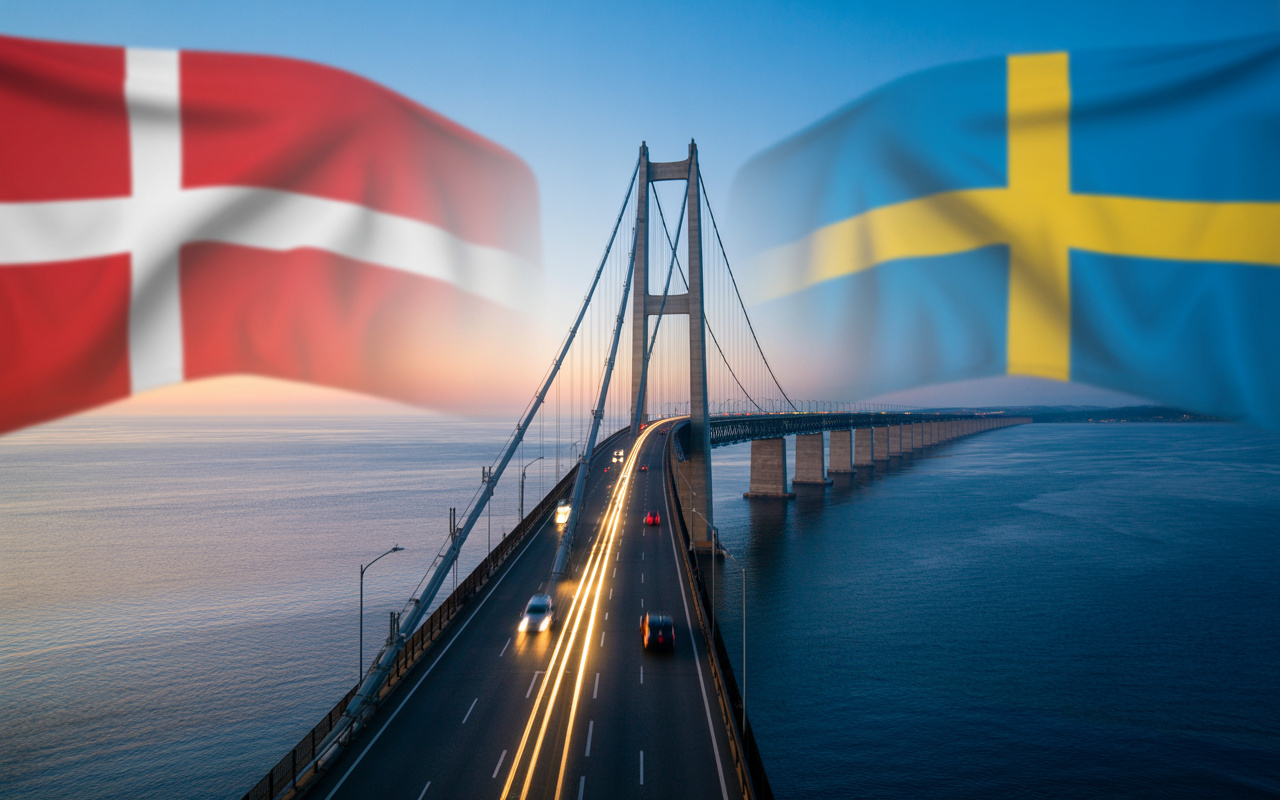
With Almost 8 Km Over The Sea, The Øresund Bridge Integrates Denmark And Sweden, Creates Daily Corridor For Work And Tourism And Moves Billions In Regional Investments.
When the Øresund Bridge began operations in 2000, what was inaugurated was not just a steel and concrete structure of 7.8 kilometers in length over the sea. One of the largest experiments in binational urban integration ever carried out in Europe was born there. For the first time, two large cities from different countries — Copenhagen and Malmö — began to function, in practice, as parts of the same cross-border metropolis.
Before the bridge, crossing the Øresund Strait required ferries, strict schedules, and logistical limitations. After it, the journey began to take about 15 to 20 minutes by train or car, completely transforming the dynamics of work, living, tourism, and investments between Denmark and Sweden.
A Project That United Cutting-Edge Engineering And Geopolitical Vision
The construction of the Øresund was not just an infrastructure decision. It was born out of a strategic agreement between two countries that understood that economy, mobility, and global competitiveness necessarily involve the physical integration of territories. The project combined:
-
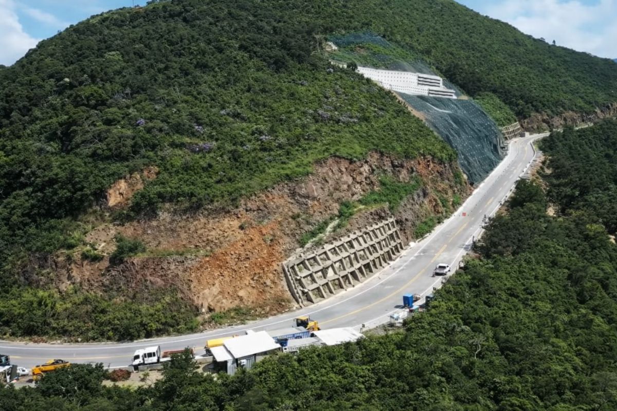
The section of Serra da Rocinha on BR-285 is now open in Timbé do Sul: 50 m tensioned curtains and top-down technique stabilize the slope, with a stairway duct controlling the water.
-
Scientists use sawdust mixed with clay to create a lighter brick, promising efficient thermal insulation and impressing by transforming waste into a solution for construction.

-
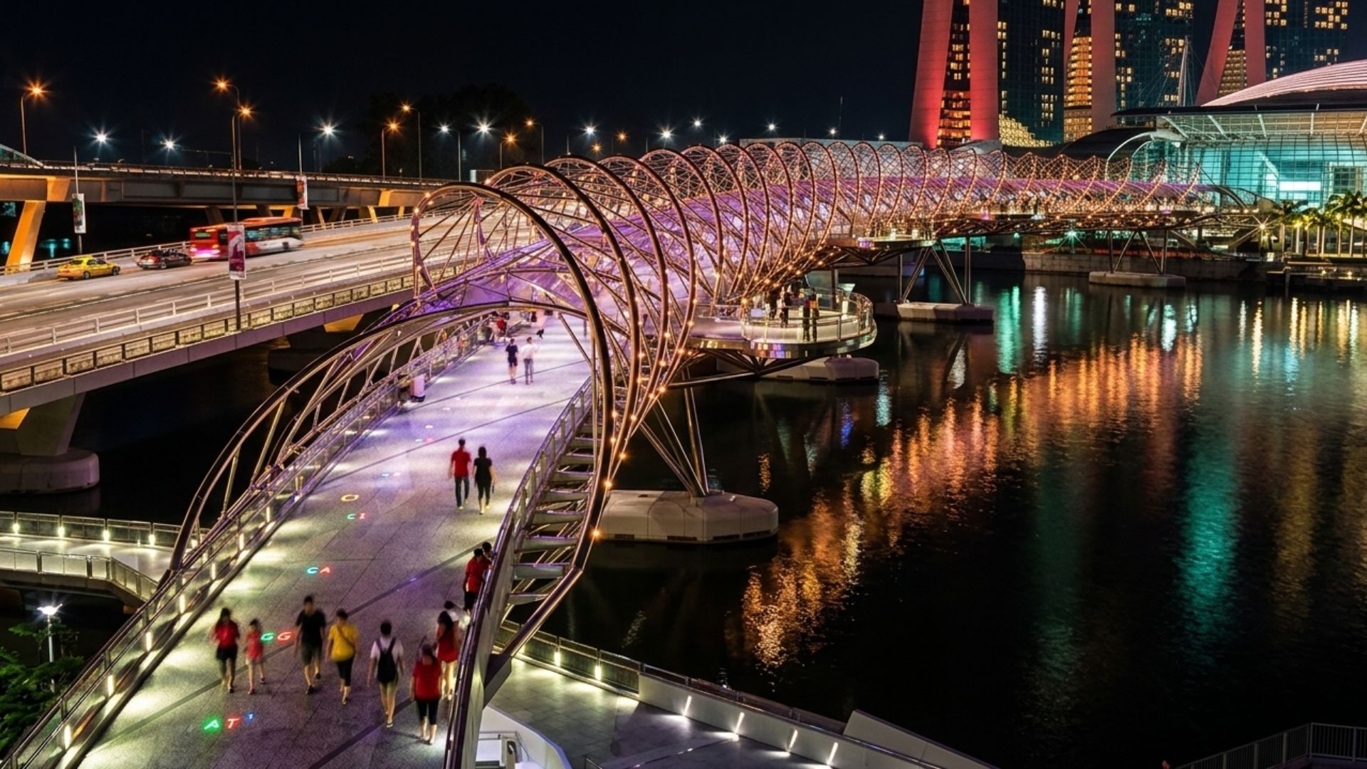
With a DNA shape, this bridge in Singapore draws attention in modern architecture and surprises tourists by transforming a simple crossing into an unforgettable visual experience in the urban heart.
-
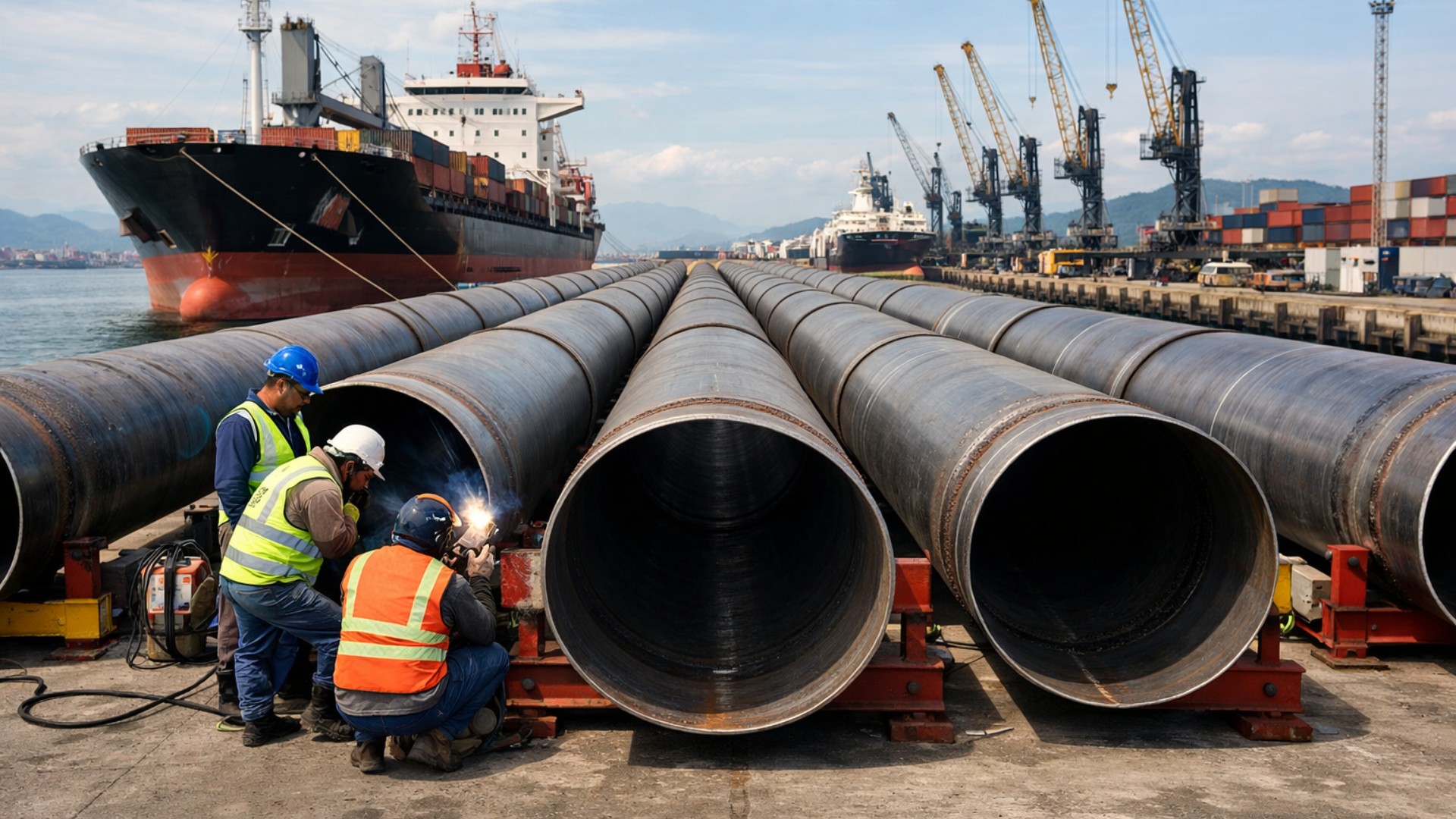
Giant underwater pipeline begins to take shape with a R$ 134.7 million project at the Port of Santos: the 1.7 km structure uses 12-meter and 700 mm pipes to supply water to 450,000 people in Guarujá.

- an elongated cable-stayed bridge over the sea;
- an underwater tunnel near Copenhagen;
- an artificial island built solely to connect the bridge and tunnel.
This arrangement was necessary to not interfere with the air routes of Copenhagen Airport, one of the busiest in Scandinavia. The result was a rare hybrid engineering solution in the world, combining a bridge, tunnel, and artificial island into a single continuous system.

The Real Dimension Of The Work That Redesigned The Region
The numbers of the Øresund make it clear why it became a symbol of continental integration:
- 7.8 km of main bridge length;
- 4 km of underwater tunnel;
- 4 km of land access;
- more than 15 km of continuous infrastructure combining all sections;
- two traffic levels: road on the upper part and rail on the lower.
This configuration allows for the simultaneous traffic of cars, buses, trucks, and high-capacity trains, creating one of the most efficient multimodal corridors in Europe.
When Two Cities Became One Metropolitan Region
The urban impact was immediate. Professionals living in Malmö began working daily in Copenhagen. Danes started living in Sweden, where the cost of living was lower, while working in the Danish capital, where salaries were higher.
This gave rise to the so-called Øresund Region, now one of the most dynamic metropolitan areas in Northern Europe. It concentrates:
- international universities;
- research centers;
- biotechnology hubs;
- headquarters of global companies;
- pharmaceutical industry;
- clean technology startups.
The bridge literally created a new binational job market, where borders became mere administrative formalities.
The Impact On Tourism That Multiplied Regional Flow
Before the bridge, tourism between Denmark and Sweden was limited by dependence on ferries. With the Øresund, the flow exploded. Today, millions of tourists per year cross the bridge to:
- visit Copenhagen and Malmö in the same day;
- tour castles, beaches, and historical centers on both sides;
- participate in binational cultural events;
- use the region as a base to explore all of Scandinavia.
The bridge began to function as an international tourism artery, boosting local revenue, the hotel sector, and urban services.

The Logistical Axis That Reorganized All Of Scandinavia
From a logistical point of view, the Øresund has become a strategic corridor for exports and imports from Northern Europe. Goods that once relied on longer routes began circulating directly between:
- Danish ports;
- Swedish industrial centers;
- continental railway networks.
This reduced operational costs, shortened delivery times, and made the region even more attractive for European distribution centers. Today, numerous international logistics hubs have been established around the bridge precisely because of this geographical advantage.
The Direct Effect On The Real Estate Market
The physical integration completely changed the map of property prices. Malmö, which previously had values much lower than Copenhagen, began to experience a strong valuation cycle. Danes migrated to Sweden in search of lower living costs, creating demand pressure.
This generated:
- new residential neighborhoods;
- planned urban expansion;
- growth of commercial enterprises;
- increase in land and property values.
The bridge became, in practice, an international real estate engine, where living in one country and working in another became routine.
A Bridge That Moves Billions Every Year
Although exact figures vary over the years, regional estimates indicate that the direct and indirect economic activity generated by the Øresund Bridge moves tens of billions of euros per decade when considering:
- trade;
- tourism;
- real estate;
- logistics;
- cross-border jobs;
- tax revenue.
In addition, the operation of the bridge itself is tolled, ensuring a constant revenue for maintenance, rail expansion, and structural modernization.
Engineering Designed To Withstand The Sea, The Wind, And Time
The Øresund Strait is a region of strong winds, intense sea currents, and heavy naval traffic. Therefore, the bridge was designed to withstand:
- severe storms;
- continuous marine corrosion;
- impacts from naval collisions;
- simultaneous vibrations from trains and vehicles.
Sensors monitor in real-time:
- structural displacements;
- cable fatigue;
- tension in the pillars;
- thermal variations.
This is one of the most technically monitored bridges in all of Europe.
A Political Symbol Of An Integrated Europe
The Øresund is not just infrastructure. It has become a physical symbol of European integration, of free movement of people, and of cooperation among sovereign countries. In a continent historically marked by wars and rigid borders, the bridge represents:
- free movement of workers;
- university integration;
- transnational production chains;
- regional identity above formal borders.
It materializes, in steel and concrete, the idea that modern economies grow more when they connect than when they isolate.
The Bridge That Also Became A Cultural Character
The Øresund Bridge has transcended its role as an engineering work and has definitively entered popular culture. International series, documentaries, films, and suspense productions have used the bridge as a backdrop precisely because of its symbolic nature: it connects two distinct worlds over a sheet of water.
This cultural aspect has further helped to project the bridge globally, turning it into one of the most recognized postcards of Northern Europe.
Why It Is Considered One Of The Most Important Bridges On The Planet
There are longer, taller bridges with larger spans. But few have:
- direct transnational urban impact;
- economic reorganization of two major cities;
- daily integration of thousands of workers;
- direct influence on the real estate market;
- regional geopolitical role.
The Øresund not only connects shores. It merged the economies, labor markets, and lifestyles of two entire countries.


-

-

-

8 pessoas reagiram a isso.