 Portuguese
  English
  Spanish
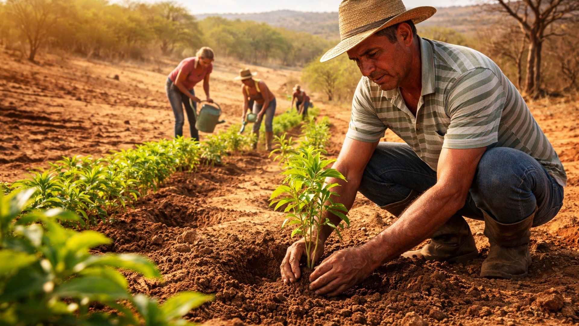
In Areas of Northeast Brazil Affected by Desertification, Rural Inhabitants Plant Trees as an Environmental and Social Resilience Strategy, Trying to Contain Soil Degradation, Reduce Water Loss and Maintain Agricultural Production in the Face of Decades of Intensive Land Use and Climate Change.
Desertification in Northeast Brazil affects 1,340,863 km² and 1,488 municipalities, according to UNCCD criteria, combining climate variations and human actions; reports in Ceará and Bahia show how families that plant trees adopt agroecological practices to contain degradation and recover soil, water, and income.
The process of desertification is internationally defined as the degradation of land in arid, semi-arid, and dry sub-humid zones, where the relationship between annual precipitation and potential evapotranspiration varies from 0.05 to 0.65.
In Brazil, this characterization primarily applies to the Northeast and northern Minas Gerais, delineating areas susceptible to desertification with cumulative environmental and social impacts.
-
Friends have been building a small “town” for 30 years to grow old together, with compact houses, a common area, nature surrounding it, and a collective life project designed for friendship, coexistence, and simplicity.

-
This small town in Germany created its own currency 24 years ago, today it circulates millions per year, is accepted in over 300 stores, and the German government allowed all of this to happen under one condition.

-
Curitiba is shrinking and is expected to lose 97,000 residents by 2050, while inland cities in Paraná such as Sarandi, Araucária, and Toledo are experiencing accelerated growth that is changing the entire state’s map.

-
Tourists were poisoned on Everest in a million-dollar fraud scheme involving helicopters that diverted over $19 million and shocked international authorities.


The areas susceptible to desertification in Northeast Brazil cover ten states, in addition to portions of northern Minas Gerais and Espírito Santo.
In these territories, land degradation does not occur suddenly, but as a succession of events that repeat over decades, forming cycles of loss of fertility, income, and social stability.
Desertification involves, simultaneously, physical, biological, and social processes. The removal of vegetation cover, intensive land use, and aggressive agricultural practices expose the land to wind and water action, favoring erosion, siltation, and surface sealing, with effects that extend beyond rural areas.

Concept of Desertification and the Extent of the Problem in Northeast Brazil
Under the United Nations Convention to Combat Desertification, desertification results from both climate variations and human activities. In Northeast Brazil, this framework recognizes regions where degradation exceeds common erosion processes and structurally compromises the productive capacity of the soil.
The areas susceptible to desertification in Brazil total more than 1.34 million km², involving 1,488 municipalities. This is a territory where knowledge about the extent and intensity of degrading processes is still considered insufficient, requiring constant updates and continuous monitoring.
According to the Ministry of Environment and Climate Change, the most advanced processes are concentrated in the so-called desertification nuclei, such as Seridó, Cariris Velhos, Inhamuns, Gilbués, Central Sertão of Pernambuco, and São Francisco Sertão. In these areas, large patches of bare soil and signs of erosion are recurrent.
Desertification in Northeast Brazil is not merely an environmental phenomenon. It implies the loss of productive territory, impoverishment of local populations, intensification of migratory flows, and increased social risk, in addition to contributing to changes in water and carbon cycles on a regional and global scale.

How Soil Degradation Evolves into Desertification
The process of desertification occurs gradually. Initially, human occupation leads to deforestation and burning of native vegetation, followed by agricultural or livestock use for several generations, often with practices that do not consider the ecological limits of the semi-arid region.
Over time, the soil loses fertility and structure. Rainwater and wind carry particles, silting rivers and ponds, while the exposed surface dries out and becomes impermeable. Vegetation loses vigor, the local atmosphere heats up, and precipitation becomes more irregular.
The reduction of soil fertility implies a decrease in productivity and family income. Unable to convert ecological assets into means of livelihood, families face deteriorating social conditions, amplifying inequalities and weakening entire rural communities.
In advanced stages, desertification leads to forced migration. Families leave the countryside and settle in peripheral urban areas, often inadequate, where they face new risks such as landslides and lack of infrastructure, characterizing a picture of social decomposition.
Irauçuba, in Ceará, and Living with Desertification

A report from Jornal Nacional showed that in the municipality of Irauçuba, in northern Ceará, desertification is visible in the landscape. The hardened soil, with a whitish color, reveals the loss of nutrients and the difficulty of regenerating plant life, even during the rainy season.
Irauçuba is part of a critical desertification nucleus recognized in the country. The so-called wounds in the soil, clearings without vegetation cover, tend to expand when there is no adequate intervention, deepening degradation and reducing the capacity for water infiltration.
Despite the adverse scenario, local experiences show important contrasts. In areas where the caatinga remains standing, producers have begun to adopt management practices that respect natural cycles, replacing the logic of confronting drought with coexistence with semi-aridity.
The change in approach includes recognizing drought as a recurring environmental behavior, just like winter in cold regions. This understanding guides adapted productive strategies capable of reducing impacts and maintaining economic activity even under extreme climatic conditions.
Regeneration, Mulch, and Recovery of Fertility
In Irauçuba, reforestation projects aim to restore native vegetation and protect the soil. Community nurseries produce seedlings, while farmers learn simple planting and soil covering techniques, reducing erosion and increasing moisture retention.
The mulch, formed by the layer of leaves and organic matter on the soil, has become a practical indicator of recovery. This cover protects the land from the sun, improves water infiltration, and favors biological activity, essential elements for reversing desertification processes.
Producers who planted trees in backyards previously considered unproductive have begun to harvest fruits such as coconut, lemon, banana, and papaya. In some cases, production generates recurring daily income, contributing to food security and the permanence of families in the territory.
The dissemination of these practices among neighbors has transformed isolated areas into continuous green patches. The contrast with degraded neighboring regions highlights the impact of low-cost interventions based on local knowledge, even in semi-arid environments.
Simple Works and Erosion Control in the Sertão
In addition to plant management, residents of the Ceará Sertão have adopted simple constructions to contain erosion. Stone bunds and small dams reduce the speed of rainwater, favoring its infiltration into the soil and decreasing sediment transport.
These structures use locally available materials, such as stones abundant in the region, and do not require complex technology. The logic is to slow down the water so that it remains in the territory, recharging the soil and groundwater.
In areas where these techniques have been continually applied, the landscape shows greater vegetation cover and lower incidence of exposed soil. The cumulative effect reinforces the importance of integrated interventions to combat desertification in Northeast Brazil.
These experiences demonstrate that environmental recovery does not depend solely on large projects, but on persistent, articulated actions adapted to local conditions, with direct participation from communities.
Synterpic Agriculture and Recovery of Degraded Areas in Bahia
In the interior of Bahia, synterpic agriculture has emerged as an alternative to recover degraded areas and reconcile agricultural production with environmental restoration. In a 500-hectare farm, agroforestry techniques have allowed reversing decades of degradation.
The agroforestry system is inspired by the original ecosystem of the region. In the Atlantic Forest, species occupy different strata of the forest, reproducing natural dynamics. Cocoa, the main crop, grows in the shade of larger trees, avoiding the logic of monoculture.
The diversity of species above and below the cocoa creates a more stable environment, with greater moisture retention and nutrient cycling. The practice eliminates the need for pesticides and chemical fertilizers, reducing costs and environmental impacts.
The success of the model attracted interest from companies and led to the training of students who replicate the methods in different regions of the country, including semi-arid areas, expanding the reach of solutions against desertification.
Agroforestry in the Semi-Arid and the Return of Water
In semi-arid regions of Bahia, areas previously used for pasture or agriculture showed compacted soil due to the cutting and burning of vegetation. The implementation of agroforestry began with the opening of trenches on contour lines to facilitate water infiltration.
The intensive planting of adapted species such as prickly pear, sisal, piteira, umburana, and mandacaru formed an active photosynthetic matrix throughout the year, regardless of rain. These species keep the soil covered and productive.
Three years after implementation, the presence of constant greenery attracted fauna that had disappeared, such as the catingueiro deer. Soil gradually improved, demonstrating that desertification can be contained with appropriate practices.
In this context, rain is seen as a bonus, not as the sole factor for success. Dew and moisture retained by the system ensure continuous gains, reinforcing adaptation to the climatic reality of Northeast Brazil.
Structural Causes and Associated Economic Pressures
The causes of desertification are related to extractive agricultural practices and human actions that deplete natural resources, especially in the Caatinga biome. Market pressure encourages the conversion of resources into products aimed at sale and export.
This logic treats the soil as an inexhaustible physical support, substituting ecological processes for external inputs and economic labor. The result is environmental and social costs that accumulate over time, exacerbating degradation.
Structural factors such as land concentration, income, biodiversity, and water, along with high population density in some areas, contribute to intensifying desertification. These elements amplify inequalities and limit the capacity of communities to respond.
Desertification in Northeast Brazil, therefore, reflects not only adverse natural conditions but also economic and political choices that have shaped land use over decades.
Social Technologies and Public Policies for Coexistence
Social technologies play a central role in confronting desertification. Plate cisterns, for example, total more than 1.3 million built units, ensuring access to water for more than 5 million people in 1,200 municipalities.
Agroecological family agriculture promotes productive intensification based on valuing local resources. The diversification of productive systems allows for forming stocks of water, food, forage, and seeds, increasing resilience.
These strategies are reinforced by social articulation and contextualized public policies, as demonstrated in research conducted by institutions in the Brazilian semi-arid region. The integration of environmental, territorial, and urban policies is indicated as fundamental.
The accumulated experience indicates that coexistence with the semi-arid requires integrated solutions capable of simultaneously addressing desertification, water insecurity, and social vulnerabilities.
Monitoring, Challenges, and Future Perspectives
The monitoring of desertification depends on temporal data series to evaluate risks, progression, and effectiveness of preventive actions. However, indicator systems are still incipient, especially regarding the assessment of soil degradation on a large scale.
The absence of consolidated metrics hinders decision-making and prioritization of critical areas. Still, empirical evidence shows that recovery practices can reverse local degradation trends.
With the advance of climate change, increased desertification processes are expected. This makes it urgent to expand successful experiences, support farmers who plant trees, and strengthen adaptation policies in Northeast Brazil.
Desertification must be seen as a pan-geospatial problem, articulated with global processes.
The stories from Ceará and Bahia show that, even in the face of limitations, the combination of local knowledge, agroecology, and collective action can contain degradation and open pathways for permanence in the territory, despite persistent challenges.
This article was prepared based on technical and conceptual information from Embrapa regarding the desertification process in Brazil, complemented by reports from Jornal Nacional / G1 on experiences of living with desertification in Irauçuba (CE) and by a report from BBC News Brasil (2022) on synterpic agriculture and recovery of degraded areas in the interior of Bahia and in the Brazilian semi-arid region.


-

-

-

-

-

12 pessoas reagiram a isso.