 Portuguese
  English
  Spanish
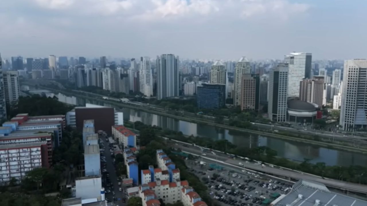


Urban Waterway Transport Comes to the Fore in the Capital with the Hydro SP Plan, Aiming for Recovered Rivers, Integration with Other Modes, and More Predictable Journeys in Congested Corridors.
The urban waterway transport is being treated as a real alternative in São Paulo, not just a curiosity. The proposal bets on the water that already flows through the metropolis to create a mobility axis capable of relieving bottlenecks, reducing dependence on asphalt, and reorganizing flows where congestion constantly changes.
The ambition is great: a network that can reach 180 km of navigable waterways, with ecoports, locks, and revitalization of the banks.
The promise is not just to “put boats on the river,” but to transform rivers into transport infrastructure, connected to the rest of the city.
-
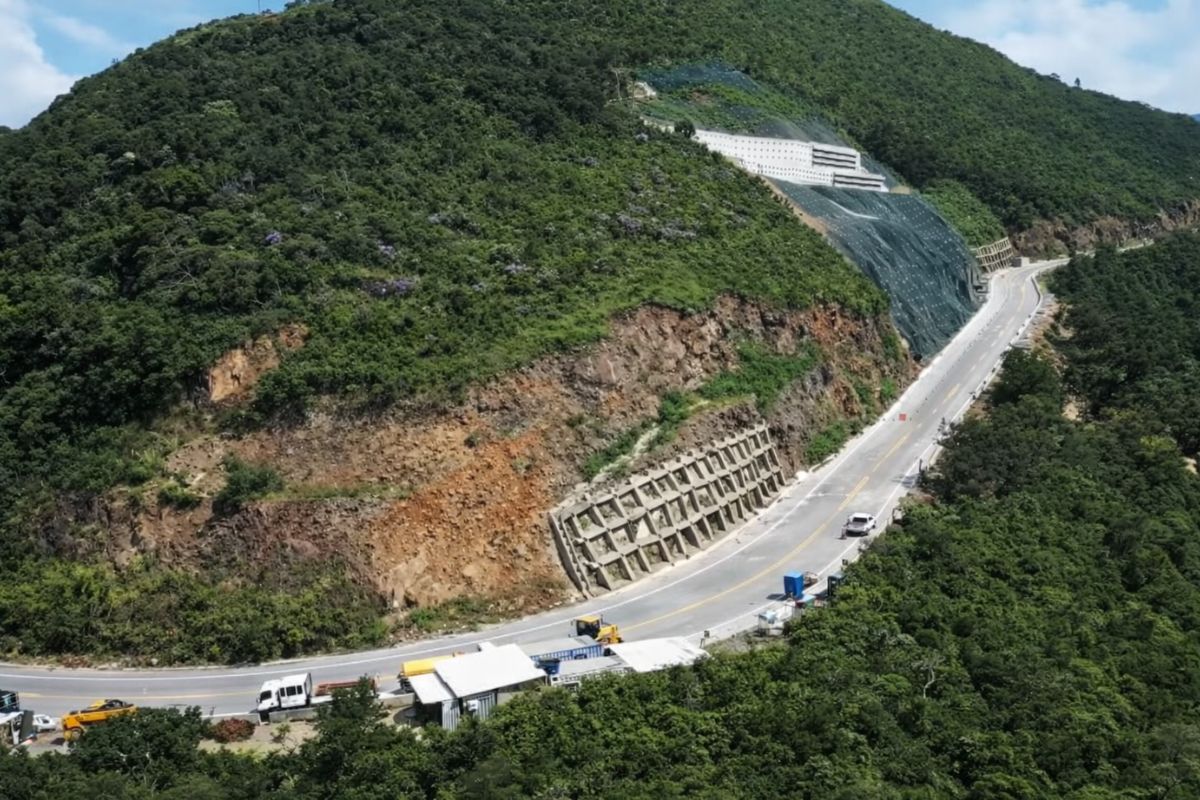
The section of Serra da Rocinha on BR-285 is now open in Timbé do Sul: 50 m tensioned curtains and top-down technique stabilize the slope, with a stairway duct controlling the water.
-
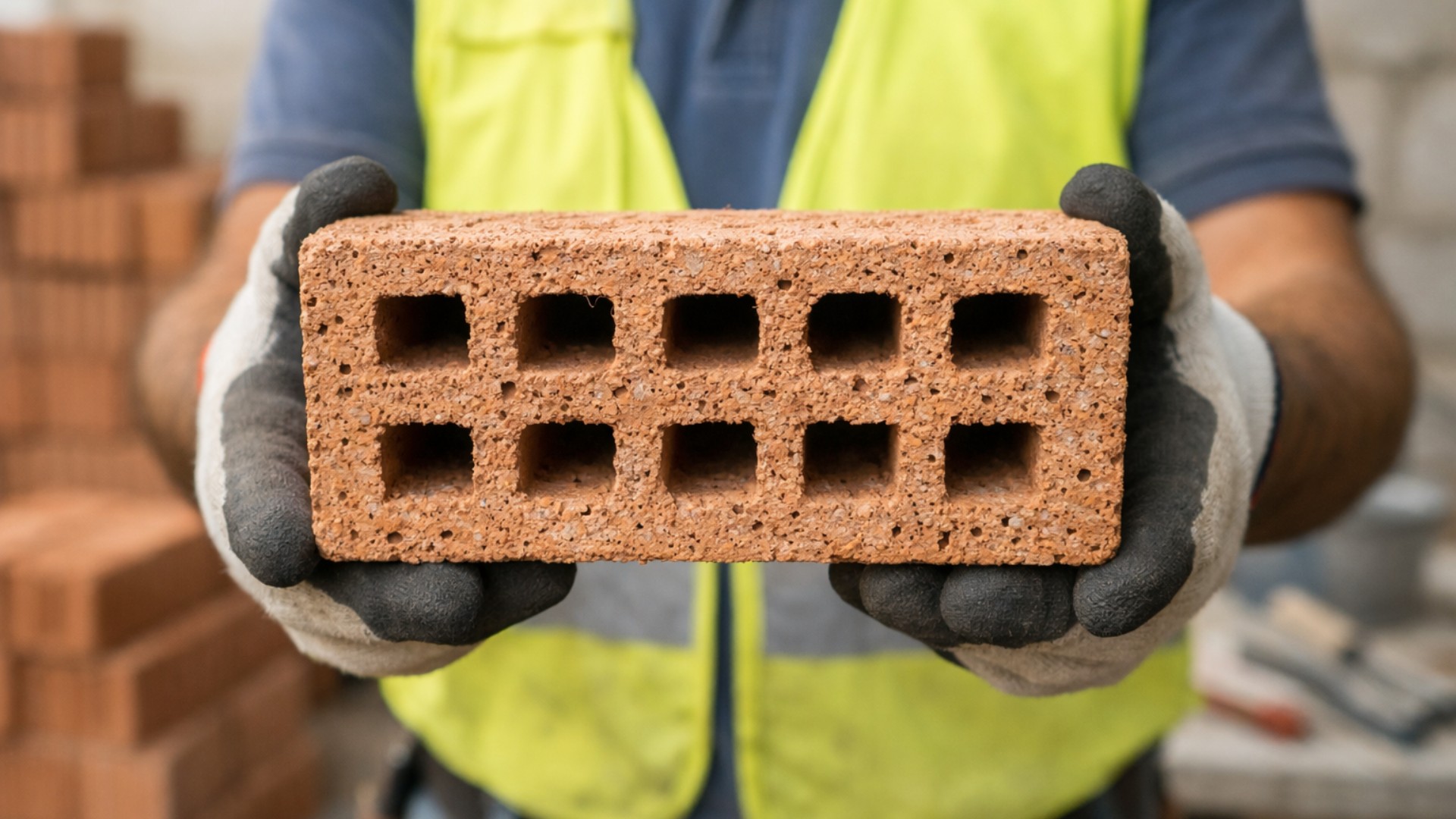
Scientists use sawdust mixed with clay to create a lighter brick, promising efficient thermal insulation and impressing by transforming waste into a solution for construction.
-
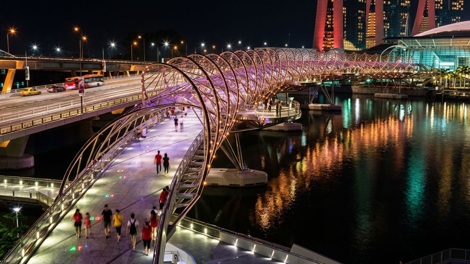
With a DNA shape, this bridge in Singapore draws attention in modern architecture and surprises tourists by transforming a simple crossing into an unforgettable visual experience in the urban heart.
-
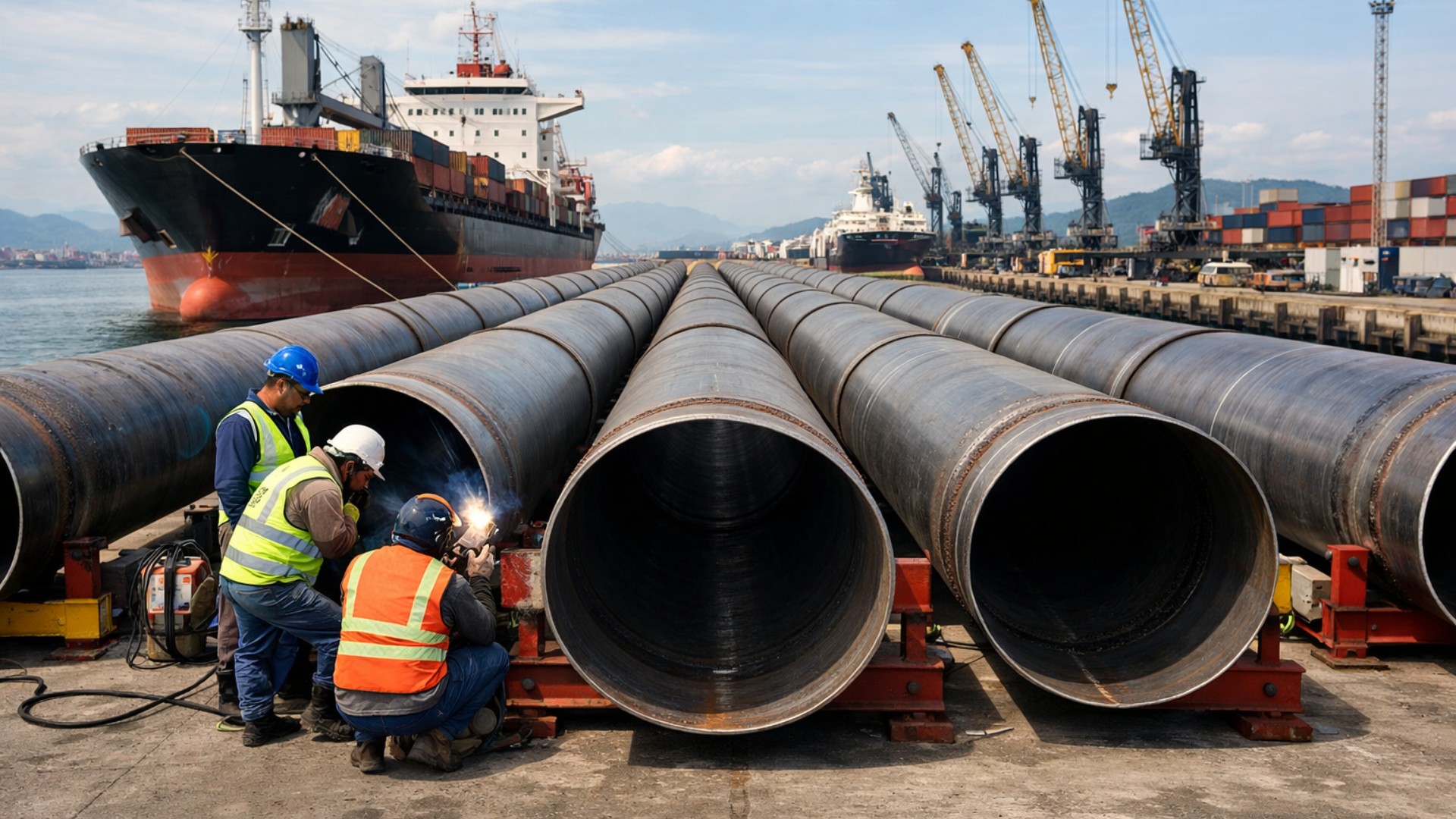
Giant underwater pipeline begins to take shape with a R$ 134.7 million project at the Port of Santos: the 1.7 km structure uses 12-meter and 700 mm pipes to supply water to 450,000 people in Guarujá.

Why São Paulo is Looking at Rivers as a Mobility Corridor

The starting point of the plan is pragmatic: while traffic turns minutes into hours, there is already a continuous layout on the map, the urban waterways. The plan seeks to restore the strategic function of rivers that have been pushed into the category of “drainage problems.”
The logic is clear. When the river becomes an axis, you create a route with less interference from traffic lights, intersections, and typical road congestion, especially in areas where mobility and economic activity overlap permanently.
The Tamanduateí as the Core of Urban Waterway Transport
The Hydro SP design is organized around the Tamanduateí River, presented as a corridor with a direct impact on displacements by traversing dense regions with intense traffic, such as areas in ABC, Brás, and the vicinity of Dom Pedro I Park.
The proposal is to reposition the Tamanduateí as a navigable waterway integrated into urban life, with access and connections that bring the riverbanks closer to the fabric of the city.
The potential gain is not only in displacements but in the reorganization of flows, because a fluvial axis can function as a structural alternative connected to transfer points with ground transportation.
The Expanded Network up to 180 km and Integration with Other Rivers and Reservoirs
The plan is not limited to the Tamanduateí. It anticipates extension with larger rivers, such as Tietê and Pinheiros, as well as connections with reservoirs like Billings and Guarapiranga. The idea is for the network to cease being an isolated section and to operate as a unified system.
This concept opens two paths. First, urban waterway transport for passengers gains real utility when it becomes a network, not when it becomes an exception.
Second, the same infrastructure can create space for, in the future, compatible cargo to circulate within the city and reduce pressure on saturated corridors.
Ecoports, Locks, and Urbanized Bridges: The Engineering Behind the Plan
The plan highlights three physical components that support the operation:
Ecoports
These are embarkation and disembarkation points that organize the interchange between the waterway and the city. The proposal considers designs aimed at passengers and a future vocation for cargo, along with supporting solutions, such as energy and local resource management.
Locks
In urban rivers with water level variations, navigability depends on control of elevations and operational safety. Locks serve as key structures to ensure regular and safe passage, with an emphasis on modern and automated models, combining civil engineering and electromechanical systems.
Urbanized Bridges and Revitalized Banks
The plan mentions 10 urbanized bridges and ongoing revitalization of the riverbank edges. The logic is “urban stitching”: more crossings and vibrant banks reduce the barrier effect and connect neighborhoods that currently face each other without truly connecting.
Before the Boat, Comes Structural Decontamination
The material leaves a non-negotiable point: the system only works with a minimally recovered river. Therefore, the plan relies on preparatory actions for cleaning, waste removal, and organizing what needs to be addressed before continuous operation can begin.
The critical stage is structural decontamination, not just “cleaning the surface.” It involves tackling continuous inflows of sewage and pollutants along the route, with sanitation systems, stations connected to tributaries, filtering, and solid retention. Without controlling the pollutant load, no timeline can be sustained.
Digital Layer and Safety: When It Becomes a Service, Not Just “Boat on the River”
For urban waterway transport to be reliable, the plan includes a monitoring and control layer: GPS-based systems, radars, and traffic control, connecting vessels, operators, and structures like locks in a coordinated flow.
This part is usually the difference between a one-off test and a stable service, with operational rules, continuous communication, and predictability of passage windows.
The Pilot in Billings and the Argument of Time Saved
The practical reference mentioned is Aquático SP, in Billings, described as a pilot project that completed a year with 500,000 passengers transported and an approval rating above 90%, with the majority use tied to commuting.
The example also illustrates the magnitude of the gain: a route of 5.6 km completed in about 17 minutes, while the same connection by bus takes around 1h20.
When this kind of difference is repeated thousands of times a week, it changes productivity and access and can even influence choices of where to work and study.
Scale, Fleet, and Cost: What the Plan Brings to the Table
In the expansion, the material mentions 40 ecoports and an estimated fleet of 71 passenger boats, designed to operate near major train and subway stations, so the boat can enter the system as part of the modal and not as an exception.
Regarding cost, the value cited for the entire set revolves around R$ 8.5 billion. The justification for the investment lies in the delivery package: recovered time, territorial integration, and reduced dependence on asphalt in a metropolis where road transport weighs more in urban life.
What Needs to Work for Urban Waterway Transport to Become Routine
The plan implicitly leaves a chain of actions that cannot be skipped:
Without comfortable crossings, the river separates
Without vibrant banks, the river isolates
Without level control, the river does not become a route
Without sanitation, the river does not become a service
If these pillars move together, São Paulo does not “discover” water; it reclaims a pathway that has always been there, but has been expelled from daily life.
Do you think that the urban waterway transport in São Paulo can truly become a day-to-day alternative, or will it remain restricted to isolated stretches and pilot projects?


Eu apoio está iniciativa porque precisamos de alternativas para transportar população de sao paulo por enquanto sem mais