 Portuguese
  English
  Spanish
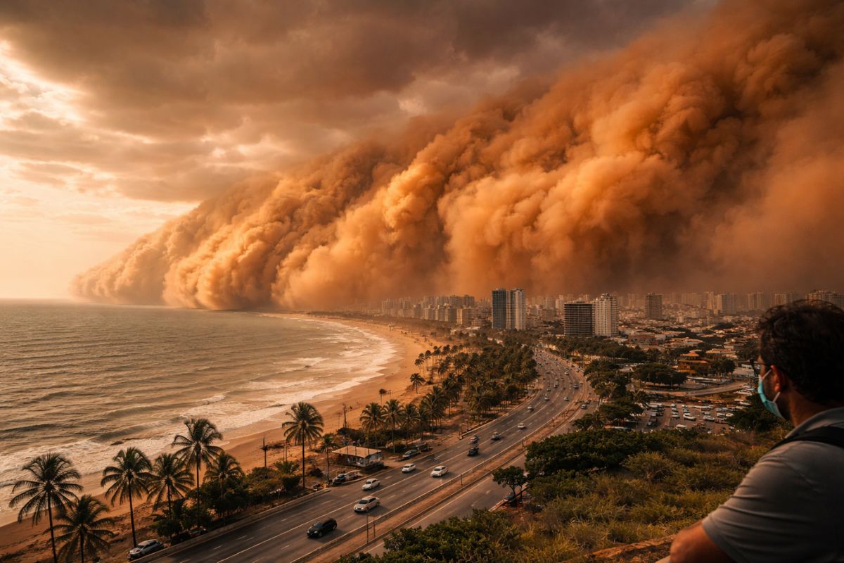
The Dust Storm From The Sahara Has Left North Africa, Crossing The Tropical Atlantic With Trade Winds And Should Reach The North And Northeast In The Next Few Days. The Plume Lifts PM10 And PM2.5 Particles, Can Reduce Visibility, Leave The Sky Whitish Or Orange, And Temporarily Irritate The Airways Here
The dust storm from the Sahara is crossing the Atlantic Ocean from North Africa and is expected to reach parts of the North and Northeast of Brazil in the coming days, according to the atmospheric forecast maps cited in the base. The most sensitive signal appears in the increase of particulate matter, especially in PM10 and PM2.5 fractions, with the potential to temporarily alter air quality.
The same transport of dust, carried by trade winds over the tropical Atlantic, also reaches countries in the Caribbean, Central America, and northern South America. The expectation is for hazier skies, reduced visibility, and temporary respiratory discomfort in parts of Brazilian territory, with greater perception precisely where the air tends to fluctuate more in dry periods.
What Is The Dust Storm From The Sahara And Why Does It Cross The Atlantic
The dust storm from the Sahara is described as an extensive mass of dust that emerges from the desert in North Africa and is pushed by trade winds that regularly blow over the tropical Atlantic.
-
Motorola launched the Signature with a gold seal from DxOMark, tying with the iPhone 17 Pro in camera performance, Snapdragon 8 Gen 5 that surpassed 3 million in benchmarks, and a zoom that impresses even at night.

-
Satellites reveal beneath the Sahara a giant river buried for thousands of kilometers: study shows that the largest hot desert on the planet was once traversed by a river system comparable to the largest on Earth.

-
Scientists have captured something never seen in space: newly born stars are creating gigantic rings of light a thousand times larger than the distance between the Earth and the Sun, and this changes everything we knew about stellar birth.

-
Geologists find traces of a continent that disappeared 155 million years ago after separating from Australia and reveal that it did not sink, but broke into fragments scattered across Southeast Asia.

The central point is not just the origin, but the transport mechanism, because it allows particles to remain suspended and travel thousands of kilometers.
This type of plume often mixes particles of various sizes. The larger ones tend to fall earlier, due to gravity, and that is why the fine fraction, capable of remaining in the atmosphere longer, reaches further.
Even when the arrival in Brazil occurs in a more dispersed manner, the base highlights that there may be temporary changes in air quality indices, precisely because fine particles take longer to settle.
PM10 And PM2.5, What Do These Numbers Mean In The Air You Breathe
The cited maps indicate an increase in particulate matter, highlighting PM10 and PM2.5. PM10 is a fraction of larger particles, still relevant for airway irritation and visible dust, but the base text draws attention to PM2.5 as the most concerning fraction from a public health perspective.
PM2.5 consists of particles with a diameter equal to or less than 2.5 micrometers.
The base provides an objective comparison: about 30 times smaller than a human hair.
This scale matters because extremely small particles can penetrate deep into the lungs and, in some cases, enter the bloodstream, which helps explain why the concern is not limited to sneezing and scratchy throats.
Where Effects Have Been Observed And Which Areas Of Brazil Should Notice More
Since Monday (23), countries such as Suriname, Guyana, French Guiana, Venezuela, Colombia, Ecuador, Peru, and Bolivia have already reported hazier skies and increased dust at medium levels in the atmosphere, according to the base.
This geographic chain serves as a clue to the plume’s path, as it shows the progression through northern South America before the impact becomes more noticeable in Brazil.
In Brazil, the base indicates that the effects are expected to be more noticeable in the North and Northeast regions, which aligns with the logic of entry through the tropical Atlantic.
Even without pinning city by city, the main warning is about an increase in fine particles, the possibility of hazy skies and reduced visibility, which may become clearer on days of stable weather, when the horizon contrast becomes more evident.
Timeline, Peak Concentration, And Expected Window Of Persistence
The base outlines a time window that helps understand the rhythm of the event.
The peak concentration would have occurred between Tuesday (24) and Wednesday (25), suggesting that the most intense part of the plume has already passed through earlier areas of the route and is now likely to spread and persist in a more diluted form.
Nevertheless, the text indicates that the effects may persist at least until Friday (27).
Persisting does not mean worsening, it means remaining present at levels capable of changing the appearance of the sky and influencing air quality measurements, especially if there is atmospheric stability.
In such events, small variations in wind and humidity can alter how visible the dust is and how much it bothers, even within the same region.
Public Health, Who Feels It First And What Symptoms Are On The Radar
The dust storm from the Sahara can increase the presence of PM2.5 and, consequently, raise the risk of irritation in the airways, worsening asthma and bronchitis attacks, as well as increasing the risk of cardiovascular problems, according to the base.
This does not turn everyone into a patient, but increases the chance of discomfort in sensitive groups and those already with chronic conditions.
Children, the elderly, and people with chronic respiratory diseases are identified as more vulnerable. During higher concentration periods, the common recommendation is to reduce outdoor activities and, if necessary, use respiratory protection.
The logic is simple: less exposure to polluted air, less chance of irritation and crisis in those with a history.
Hazy Sky, Reduced Visibility, And The Change That Appears In The Eyes Before The Body
Besides health, the dust storm from the Sahara alters the sky in a way that many people notice even before any symptoms occur.
The base speaks of reduced visibility and horizon with whitish or orange tones, especially on clear weather days.
It is the kind of change that makes the landscape look washed out, with less contrast between sky and horizon line.
The plume can also interfere with cloud formation and the occurrence of rain by altering moisture condensation processes in the atmosphere, according to the base. This is not a guarantee of rain or lack thereof, but a possibility of influence.
In practical terms, what tends to be more evident to the public is the appearance of the sky and the sensation of heavier air, especially for those who already have rhinitis, asthma, or bronchitis.
What To Do In Your Routine Without Exaggeration Or Neglect
The first step is to understand the size of the risk: the base describes temporary effects and more dispersed arrival in Brazil, but with an increase in fine particles in the air. Therefore, the most rational approach is to adjust your routine, not panic.
If You Do Outdoor Physical Activity, reducing intensity or changing the time may be enough on days of hazier skies and more irritating air.
For those who already have respiratory conditions, the care is more direct: watch for signs of an attack, maintain usual medication according to existing medical guidance, and avoid prolonged exposure.
Children and the elderly deserve extra attention, not for generic fragility, but because they react more to fluctuations in air quality. If visibility decreases, it is wise to be cautious while traveling, as suspended dust can distort distance and contrast, especially at dawn and dusk.
The dust storm from the Sahara is on a path toward Brazil after crossing the tropical Atlantic with trade winds, and the base indicates the North and Northeast as areas where the effect is likely to be most noticeable, with increases in PM10 and PM2.5, hazy skies, reduced visibility, and temporary respiratory discomfort.
What Matters Here Is The Fine Particle, as it remains suspended longer and has a greater potential impact on public health.
I want a practical and personal response: in your city, do you usually notice the change in the sky or in your body first when the air gets drier, and who in your home would feel the arrival of this dust storm from the Sahara the most, children, the elderly, or someone with asthma or bronchitis?


-

Uma pessoa reagiu a isso.