 Portuguese
  English
  Spanish
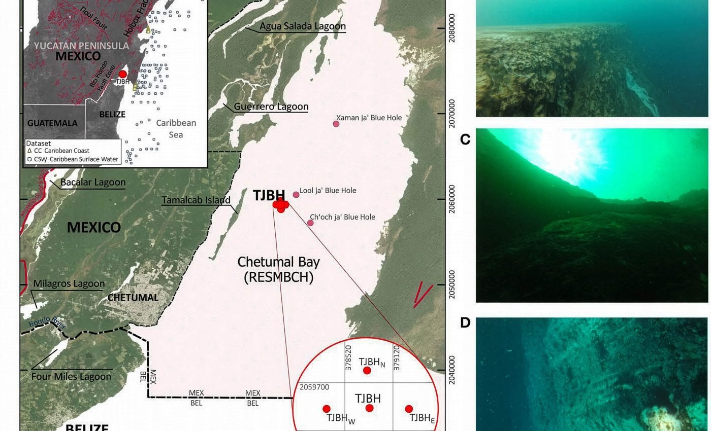


New Measurements Made in December 2023 in Chetumal Bay Show That the Blue Hole Taam Ja’ Exceeds 424 Meters in Depth, Surpassing the Previous Estimate of 274 Meters and Exhibiting Layers of Water with Distinct Characteristics Without Reaching the Bottom
Scientists identified that the blue hole Taam Ja’, in Chetumal Bay, exceeds 424 meters in depth after two expeditions in December 2023. The new measurements surpass the previous estimate of 274 meters and did not reach the bottom.
The blue hole Taam Ja’ is located beneath the seemingly calm surface of Chetumal Bay. The formation, described as an underwater sinkhole, became a focus of investigation after initial sonar readings indicated about 274 meters in depth.
However, the latest measurements revealed much higher values. In two descents with a CTD profiler, about 416 meters were recorded on one day and approximately 423.6 meters on another, without the instrument reaching the bottom.
-
Motorola launched the Signature with a gold seal from DxOMark, tying with the iPhone 17 Pro in camera performance, Snapdragon 8 Gen 5 that surpassed 3 million in benchmarks, and a zoom that impresses even at night.

-
Satellites reveal beneath the Sahara a giant river buried for thousands of kilometers: study shows that the largest hot desert on the planet was once traversed by a river system comparable to the largest on Earth.

-
Scientists have captured something never seen in space: newly born stars are creating gigantic rings of light a thousand times larger than the distance between the Earth and the Sun, and this changes everything we knew about stellar birth.

-
Geologists find traces of a continent that disappeared 155 million years ago after separating from Australia and reveal that it did not sink, but broke into fragments scattered across Southeast Asia.

Blue Hole Taam Ja’ and the Need to Determine Shape and Depth
The blue hole is considered a potential natural laboratory. Structures of this type can connect to cave systems beneath the seabed or accumulate layers of sediments that record past storms, climate changes, and variations in sea level.
Before investigating these issues, researchers need to determine the shape of the blue hole and its true depth. The absence of a definitive value hinders more detailed analyses of the stability of the layers and internal processes.
The initial uncertainty arose because the plan was simple: map with sonar, obtain the depth, and conclude the preliminary phase. However, the first readings raised the possibility that Taam Ja’ might be deeper than the initial numbers suggested.
Limitations of Sonar in a Stratified Blue Hole
Sonar works by sending sound waves and measuring the time it takes for the echo to return. Under normal conditions, it is a reliable method. However, in a blue hole, changes in temperature and salinity can bend or disperse sound waves.
If the signal bounces off sloped walls, protrusions, or irregularities, it may return sooner than expected. The early return causes the equipment to identify a bottom that does not correspond to the actual deepest point.
Moreover, the shape of a blue hole is rarely a straight tube. It may incline, narrow, open into chambers, or branch out. In this scenario, a device dropped vertically may not hit the deepest point directly below the opening.
Observations from Divers in the First 30 Meters
To understand the upper part of the blue hole, divers explored down to about 30 meters. Below the murky surface of the bay, the outline of the opening became more visible.
The walls were not uniform. In certain stretches, the material appeared soft and fragile. Some surfaces were covered with biofilms, viscous layers formed by microorganisms.
At the end of the dive, the walls became steeper, with firmer rock and fewer visible coatings. These observations reinforced the structural complexity of the blue hole.
Measurement with CTD Profiler and Increase in Recorded Depth
Given the limitations of sonar, the team used a CTD profiler, standing for conductivity, temperature, and depth. Conductivity allows for estimating salinity, temperature is measured directly, and depth is calculated by pressure.
Pressure increases predictably, about one atmosphere for every 10 meters of seawater. Therefore, measurements based on pressure tend to be more reliable when acoustics are compromised.
During two expeditions in December 2023, a boat was anchored over the blue hole. The CTD was lowered by a cable of approximately 500 meters. The readings indicated depths less than the length of the cable.
This suggests that the instrument did not descend in a straight line. Currents may displace the cable laterally, and the interior of the hole may guide the equipment along angled trajectories.
On one of the days, the CTD reached about 416 meters below sea level. On another, it achieved approximately 423.6 meters, still without touching the bottom. Thus, it was concluded that the blue hole has more than 1,390 feet of depth.
Layering Inside the Blue Hole
Besides the depth, the CTD revealed strong stratification. Several pycnoclines were detected, bands where density varies rapidly. These zones resist mixing, maintaining layers separated for long periods.
Near the surface, the conditions were typical of an estuary, with warmer and less saline water than the open ocean. This corresponds to a partially enclosed bay receiving freshwater input.
As the instrument descended, temperature and salinity changed in stages, with abrupt jumps marking clear boundaries. Below approximately 400 meters, the trend reversed.
The temperature began to rise slightly, while salinity increased even more. This combination indicates that the deeper water has a distinct origin, with its own signature.
Comparisons with regional waters showed that the upper layers coincide with the mixed water of the bay. In contrast, the deeper layers present values more typical of Caribbean seawater.
This data does not prove the existence of a large open tunnel directly connecting the blue hole to the Caribbean. However, it reinforces that the deep water does not originate solely from the bay above.
Geological Context and Next Steps in Studying the Blue Hole
The Yucatán Peninsula is primarily composed of limestone, a rock that dissolves over time, creating voids and networks of caves. Historical changes in sea level flooded many of these spaces.
This geological context makes it plausible that complex systems exist where freshwater and seawater meet and move intricately. The next objective is to obtain a detailed 3D model of the interior.
There is also an effort to confirm the real depth of the bottom of the blue hole. With this foundation, it will be possible to investigate the stability of the layers, variations in oxygen and other chemicals, as well as microbial communities.
For now, the blue hole Taam Ja’ is partially defined by the unknown. It is known to exceed 424 meters and that the bottom has not been reached. These facts alter the planning of future dives and sampling strategies.
If deeper waters enter the system and if the layers remain separated, the blue hole is not just a deep well. It is a connected, structured, and active entity, the understanding of which is still in development.
The complete study was published in the journal Frontiers in Marine Science.


Meteoro que dizimou os dinos deixou cicatrizes profundas em Yucatan