 Portuguese
  English
  Spanish
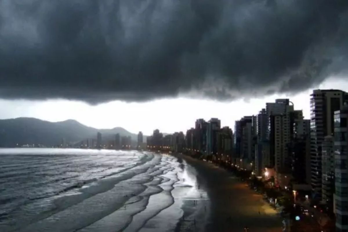
Between Monday and Tuesday, the combination of heat above 30°C in all regions, peaks of 35°C in the West and high humidity increases the risk of thunderstorms with heavy rain, lightning, strong winds, flooding, and landslides, keeping the state on alert also in the following days, until Sunday with oppressive heat.
Santa Catarina opens the week under a typical summer scenario: widespread heat, high humidity, and a growing potential for thunderstorms between afternoon and evening. With highs above 30°C throughout the state and the possibility of exceeding 35°C in the West and the Itajaí Valley, the meteorological risk ceases to be routine and begins to require practical attention.
The most critical period concentrates between Monday (16) and Tuesday (17), when the Civil Defense classifies the risk of occurrences between the Midwest and the Coast as high. In the alert map, the expected impact ranges from urban disruptions, such as flooding and roof damage, to threats on already saturated slopes, where new landslides remain on the radar.
Where the Risk Gains Scale Between Monday and Tuesday
The weather alert began at noon on Monday (16) and continues until 11 PM on Tuesday (17), a time frame that concentrates the greatest potential for thunderstorms with broader effects. During this period, the accumulated heat throughout the day meets enough humidity to intensify rain cores and raise the chances of lightning, gusts, and hail.
-
Motorola launched the Signature with a gold seal from DxOMark, tying with the iPhone 17 Pro in camera performance, Snapdragon 8 Gen 5 that surpassed 3 million in benchmarks, and a zoom that impresses even at night.

-
Satellites reveal beneath the Sahara a giant river buried for thousands of kilometers: study shows that the largest hot desert on the planet was once traversed by a river system comparable to the largest on Earth.

-
Scientists have captured something never seen in space: newly born stars are creating gigantic rings of light a thousand times larger than the distance between the Earth and the Sun, and this changes everything we knew about stellar birth.

-
Geologists find traces of a continent that disappeared 155 million years ago after separating from Australia and reveal that it did not sink, but broke into fragments scattered across Southeast Asia.

In the area breakdown, the Great West and a small part of the Midwest appear at an attention level, while the orange alert reaches a broader range: Midwest, Southern Plateau, Northern Plateau, Medium and High Itajaí Valley, Greater Florianópolis, Northern Coast, Southern Coast, and Lower Itajaí Valley. This means that the risk is not homogeneous but is distributed across practically the entire map of Santa Catarina.
Why Heat Up to 35°C Accelerates Thunderstorm Formation
The central factor of the week is the combination of high temperature with high humidity. When the heat rises above 30°C in all regions and can reach 35°C in specific areas, the atmosphere gains energy to develop denser clouds by the end of the day. This thermal energy transforms oppressive heat into instability.
In practice, this mechanism explains why thunderstorms tend to form between afternoon and evening: daytime heating reaches its peak, humidity is already available, and the atmosphere responds with stronger and faster showers.
Rather than continuous and uniform rain, the expected pattern is for localized, yet potentially severe, episodes, with a lot of water in a short time.
From Hail to Landslide: How Impacts Change According to Territory
In urban areas and sections with overloaded drainage, the biggest problem tends to be the sudden accumulation of water.
Even when the rain lasts a short time, the intensity can cause flooding, hinder movement, and increase the risk of damage to properties and businesses. The same storm can have very different effects in neighboring neighborhoods.
In regions with a recent history of saturated soil, the scenario takes on a different weight: concerns grow regarding flash floods and landslides, especially on vulnerable slopes.
At the same time, gusts of wind can cause roof damage, falling branches and trees, as well as impacts on the power grid. Therefore, the high risk indicated for the beginning of the week involves not only heavy rain but a set of cascading threats.
Wednesday, Thursday, and Friday: The Pattern Changes, Not the Discomfort
On Wednesday (18), thunderstorms continue but with more isolated behavior. This reduces the scope of simultaneous events, but maintains the possibility of intense rain in a short period. Less comprehensive does not mean harmless: the chance of localized disruption remains present.
Between Thursday (19) and Friday (20), the passage of a cold front favors rain showers again, especially in areas close to the border with Rio Grande do Sul.
Still, the indicated trend is to maintain the summer pattern, with persistent heat and a feeling of oppression throughout the week and also into the weekend, with sun in the morning and rain between afternoon and evening.
What to Observe During the Day to Understand When the Thunderstorm May Worsen
In the rhythm of this week, signs such as oppressive mornings, rapid temperature increases, and increased cloud cover throughout the afternoon serve as indicators that the thunderstorm may gain strength by the end of the day.
This daily monitoring helps interpret better why some periods seem stable and, a few hours later, change drastically.
The recent rainfall history in the area where each person is also weighs in. In regions with already saturated soil, the threshold for new problems is lower, and shorter episodes can cause relevant impacts.
The week in Santa Catarina begins with a clear picture: high heat, high humidity, and a critical window between Monday (16) and Tuesday (17), with continued instability in the following days.
The thunderstorm ceases to be a distant possibility and becomes a concrete risk, with effects that vary from region to region and from neighborhood to neighborhood.
In your city, what tends to cause more impact when this pattern sets in: rapid flooding, power outages, strong winds, or risk on slopes? And in your neighborhood, what time does the rain most often intensify – late afternoon or early evening? Share your real experience: this local picture helps understand how the same event affects each area differently.


-

-

-

-

-

-

37 pessoas reagiram a isso.