 Portuguese
  English
  Spanish
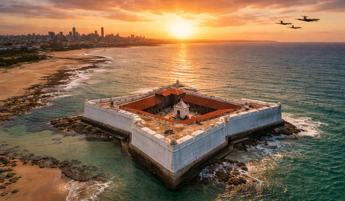
Between Colonial Fortress and Air Route of World War II, Natal Combines Strategic Geography, Military Memory, and Landscapes of Dunes and Reefs in a Destination Marked by Constant Winds and Persistent Heat That Shaped Both Its History and Current Tourism.
On the coast of Rio Grande do Norte, Natal brings together two traits that frequently appear in historical records and tourism promotion: the geographic position closest to the Americas in relation to Africa and the combination of sun, winds, and sea that sustains its image as a beach destination throughout the year.
This condition also contributed to the city and neighboring Parnamirim gaining logistical relevance during World War II when they began to operate as a support point for crossings in the South Atlantic.
The same coastal strip that today concentrates hotels, services, and tours was, at another time, a corridor considered strategic by allied forces.
-
Friends have been building a small “town” for 30 years to grow old together, with compact houses, a common area, nature surrounding it, and a collective life project designed for friendship, coexistence, and simplicity.

-
This small town in Germany created its own currency 24 years ago, today it circulates millions per year, is accepted in over 300 stores, and the German government allowed all of this to happen under one condition.

-
Curitiba is shrinking and is expected to lose 97,000 residents by 2050, while inland cities in Paraná such as Sarandi, Araucária, and Toledo are experiencing accelerated growth that is changing the entire state’s map.

-
Tourists were poisoned on Everest in a million-dollar fraud scheme involving helicopters that diverted over $19 million and shocked international authorities.


Alongside this past, Natal preserves a landmark predating the city’s very foundation: a star-shaped fortress at the mouth of the Potengi River, built in the 16th century.
Forte dos Reis Magos: The Star-Shaped Fortress at the Mouth of the Potengi
The Portuguese occupation in the region began with a military structure.
On January 6, 1598, on the Epiphany, the construction of the Forte dos Reis Magos at the mouth of the Potengi River began, under the orders of Philip II, in the context of the Iberian Union, when Portugal and Spain were under the same monarch.
Historical sources associate the work with the attempt to consolidate dominion over the coastline and to contain the actions of French privateers, mentioned in narratives about the smuggling of brazilwood.

The star shape, with five points, follows defensive models used at the time to expand the field of vision and fire.
The foundation of Natal only occurred on December 25, 1599, nearly two years after the start of the fortification.
It is this temporal difference that often appears in explanations about the origin of the name of the state capital.
The fort was listed by the Iphan in 1949 and underwent conservation and restoration processes recorded in materials from the agency itself.
Visitation includes internal areas and elements associated with military use, such as cannons, as well as a chapel.
In cultural promotion materials, there are references to the Marco de Touros, a Portuguese possession marker dated 1501 and associated with the Portuguese presence on the coast.
As this object underwent displacements and institutional custody over time, the identification of where it is on display may vary depending on the period and the collection consulted.
Parnamirim Field and the “Trampoline of Victory” in World War II
During World War II, Natal’s position in the South Atlantic was used to shorten travel routes between America and Africa.
From 1942, the base of Parnamirim Field, in Greater Natal, began to concentrate operations and support for aircraft in transit to North Africa and, later, to the European theater.
Estimates mentioned in historical publications and local memory initiatives indicate that about 20,000 aircraft passed through the structure over the period.
The nickname “Trampoline of Victory” became popular precisely because of the idea of an air bridge and quick connection between continents.
There are also recurring numbers regarding the presence of American military personnel, with records mentioning the passing of thousands of soldiers through the region.

The exact dimension varies according to the source and the adopted framing, but the volume is pointed out as sufficient to produce effects on urban daily life, such as changes in commerce and greater circulation of foreign cultural references.
In the diplomatic field, the most remembered episode occurred on January 28, 1943, when Getúlio Vargas and Franklin D. Roosevelt met in Natal at the event known as the Potengi Conference.
The meeting is cited as a milestone in Brazil–United States relations during the conflict.
Part of this past can be revisited in Parnamirim, at the Centro Cultural Trampolim da Vitória, which gathers items related to the base and the wartime period, such as documents, objects, and pieces associated with aviation and foreign presence.
What to Do in Natal Besides the Beaches: Dunes, Urban Park, and Reefs
The coastal strip usually concentrates most of the tourist flow, highlighting Ponta Negra, an urban beach associated with Morro do Careca, a dune surrounded by vegetation and protected by preservation rules.
Along Via Costeira, viewpoints and access points to the sea help connect beaches and hotel areas.
Off the beach line, the Parque Estadual Dunas do Natal stands out as one of the main conservation areas within the urban perimeter.
The space was created in 1977 and is managed by Idema, with trails and environmental education actions.
In institutional and promotional materials, the park is described as a relevant protection area for remnants of the Atlantic Forest and for the dynamics of the dunes in the city.
In the metropolitan region, the Dunes of Genipabu, in the municipality of Extremoz, concentrate buggy rides and stops at lagoons.
Operators and guides usually present the route with the question “with or without thrill?”, a phrase used to differentiate between faster stretches with steep descents and a more moderate route.
On the northern coast, the Parrachos de Maracajaú, in Maxaranguape, are sought after on days of lower tides when natural pools and reef areas become more accessible.
Tourism operators and visitor orientation agencies recommend paying attention to tide tables and sea conditions because the experience directly depends on water level and visibility.
On the southern coast, in Parnamirim, the Cajueiro de Pirangi is marketed as the largest cashew tree in the world, with an area often estimated at about 8,500 m².
The explanation presented in tourist materials attributes its expansion to a genetic anomaly that caused branches to grow and spread, creating the appearance of several connected trunks.
Climate in Natal: When It Rains More and How That Changes the Tours
Natal’s fame as the “City of the Sun” is reinforced by climatic data indicating high temperatures and relatively small variation throughout the months.
Climatology series used by meteorological services indicate that the highest volumes of rain tend to concentrate between autumn and winter, with a higher frequency of precipitation between March and July.
Even in the rainiest period, it is common to have alternation between downpours and sun breaks, a pattern mentioned in meteorological descriptions of the Northeast coast.
In practice, the choice of itinerary usually considers this behavior: when the weather is more stable, activities at sea and visits to reefs take priority.

On days of instability, some visitors combine beach with historical and cultural tours, such as the Forte dos Reis Magos and spaces dedicated to the memory of World War II.
The mention of “300 days of sun per year”, used in different promotional materials, circulates as an estimate, but does not always appear linked to a standardized climatological series.
Therefore, the data should be read as a promotional reference and not as a unique and consensual statistic.
How to Get to Natal and Travel Between Beaches and Attractions
The main air access is via the Governador Aluízio Alves International Airport, in São Gonçalo do Amarante, with the journey to Natal varying according to the point of arrival and destination within the city.
By car, BR-101 connects the capital to Recife and Fortaleza, along routes used by those traveling along the coast.
For internal circulation, travel usually occurs by taxi and apps, as well as transfers, vans, and contracted tours, especially for those intending to go from the urban area to Genipabu, Maracajaú, or Pirangi.
In many itineraries, the buggy appears as a mode of tour, operated by drivers and companies involved in dune tourism.


-

-

-

-

9 pessoas reagiram a isso.