 Portuguese
  English
  Spanish
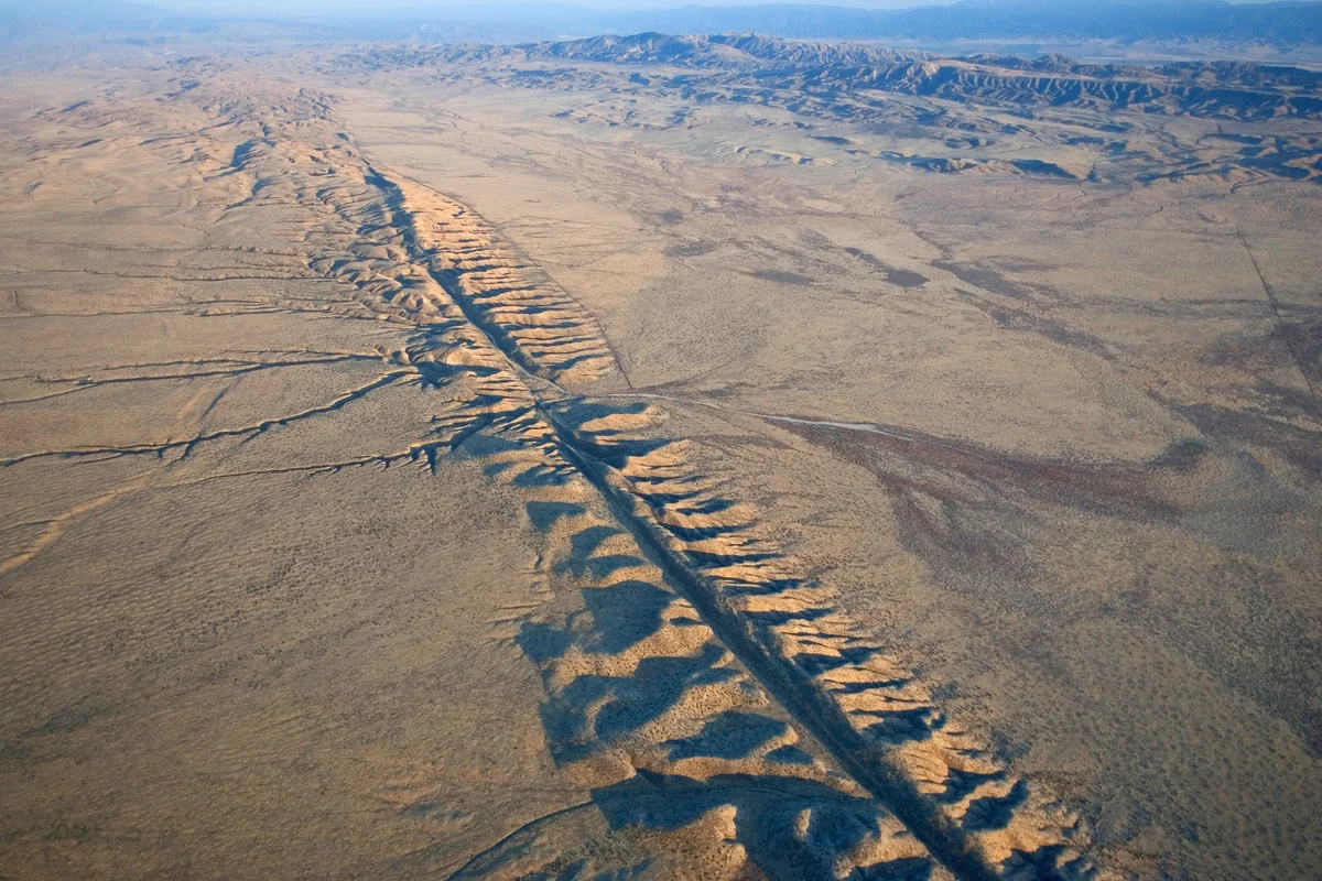
San Andreas Fault Moves Up to 3.5 Cm Per Year in California, Accumulates Seismic Tension for Centuries, and Influences Earthquakes That Could Redefine the West of the USA.
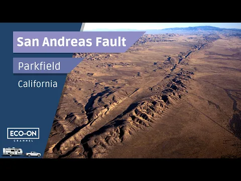
In the western United States, more specifically in the state of California, one of the most studied and monitored geological structures on the planet is in continuous motion. The San Andreas Fault, a tectonic system about 1,300 kilometers long, runs through the state from south to north and marks the boundary between two giant plates of the Earth’s crust: the Pacific Plate and the North American Plate. This movement is neither speculative nor recent. It is measured annually by geodetic GPS networks operated by organizations such as the U.S. Geological Survey (USGS) and U.S. universities, with continuous records since the 1990s.
The data show that, depending on the section of the fault, the relative movement between the plates varies between 2 and 3.5 centimeters per year, a small value on a human scale, but massive in geological terms. This constant slipping is what causes parts of California, technically, to be moving slowly to the northwest, toward Alaska, over millions of years.
Where Exactly Is the San Andreas Fault and Why Is It So Important
The San Andreas Fault cuts through densely populated regions, including areas near Los Angeles, San Bernardino, Palm Springs, San José, and south of the San Francisco Bay.
-
Friends have been building a small “town” for 30 years to grow old together, with compact houses, a common area, nature surrounding it, and a collective life project designed for friendship, coexistence, and simplicity.

-
This small town in Germany created its own currency 24 years ago, today it circulates millions per year, is accepted in over 300 stores, and the German government allowed all of this to happen under one condition.

-
Curitiba is shrinking and is expected to lose 97,000 residents by 2050, while inland cities in Paraná such as Sarandi, Araucária, and Toledo are experiencing accelerated growth that is changing the entire state’s map.

-
Tourists were poisoned on Everest in a million-dollar fraud scheme involving helicopters that diverted over $19 million and shocked international authorities.


Unlike deep, invisible faults, at many points it is clearly visible in the landscape, forming linear valleys, escarpments, diverted river courses, and anomalous alignments of lakes.
Tectonically, it is a transform fault, meaning that the plates do not collide or move apart vertically. They slide laterally past one another.
This type of movement explains why the region does not have active volcanoes associated with the fault, but conversely, it concentrates some of the most destructive earthquakes in U.S. history.
A Slow Movement That Does Not Alleviate Danger
The fact that the fault moves a few centimeters per year does not mean that energy is being released safely. On the contrary. In many sections, especially in the so-called “blocked segment”, the plates become stuck due to friction for decades or centuries.
Elastic tension accumulates until the system can no longer bear it, releasing energy suddenly in the form of large magnitude earthquakes.
According to the USGS, critical parts of the fault, such as the southern segment between the Mojave Desert and the Los Angeles area, have not completely ruptured since 1680, accumulating energy for over 300 years. This data is one of the main reasons scientists consider this segment one of the most dangerous in the country.
Scientific Evidence of Continuous Displacement
The proof of California’s annual displacement does not come from theoretical estimates but from direct measurements. High-precision GPS stations, fixed to the ground on both sides of the fault, record millimetric variations in ground position. This data is analyzed by teams from the USGS, the California Geological Survey, and academic centers like the University of California, Berkeley.
These measurements show, for example, that points located west of the fault, technically on the Pacific Plate, are moving to the northwest faster than areas to the east, which are stuck to the North American Plate. Over thousands and millions of years, this lateral movement has already displaced entire regions by hundreds of kilometers.
Historical Earthquakes That Confirm Accumulated Risk
History provides concrete examples of what happens when this accumulated energy is released. On April 18, 1906, an earthquake estimated at 7.8 in magnitude ruptured about 480 kilometers of the San Andreas Fault, destroying much of San Francisco and killing more than 3,000 people.

The observed horizontal displacement in fences, roads, and railroad tracks reached 6 meters in some places, a value consistent with centuries of accumulated movement released at once.
Another notable event occurred in 1989, the Loma Prieta earthquake, which, although smaller, again demonstrated how modern urban areas remain vulnerable to active faults.
Is California Really Going to “Split in Half”?
From a scientific perspective, the idea that California will “fall into the sea” or completely separate from the continent is incorrect.
What occurs is a continuous lateral displacement, not a rupture that opens an ocean. Over very long geological timescales, parts of California may end up attached to regions further north on the North American Plate, but this would take tens of millions of years.

Still, the impact on society does not lie in the displacement itself, but in the earthquakes associated with this movement. Even a few centimeters per year, when locked, represent enough energy to generate events capable of paralyzing entire cities, disrupting global supply chains, and causing losses of hundreds of billions of dollars.
Constant Monitoring and Limited Predictions
Currently, the San Andreas Fault is one of the most monitored geological structures in the world. In addition to GPS, scientists use seismographs, deformation sensors, satellite imagery, and paleoseismic studies, which analyze sediment layers to identify ancient earthquakes.
Despite this, there is no technology capable of predicting exactly when a major earthquake will occur.
What scientists can do is estimate probabilities. Official reports from the USGS, published in recent years, indicate that there is a significant chance of an earthquake of magnitude 7 or greater hitting California in the coming decades.
An Invisible Movement That Is Already Shaping the Future
Even without changing the political map today, the continuous displacement of the San Andreas Fault is already influencing urban planning decisions, building codes, and public policies.
Buildings, bridges, aqueducts, and pipelines in California are designed with expected seismic displacements in mind, something rare in other parts of the world.
In summary, California is not static. It moves every year, centimeter by centimeter, driven by tectonic forces that have been operating since before human existence. This silent movement, documented by robust scientific data, does not change borders today, but defines the risks, costs, and structural challenges of the future of the western United States.


Seja o primeiro a reagir!