 Portuguese
  English
  Spanish
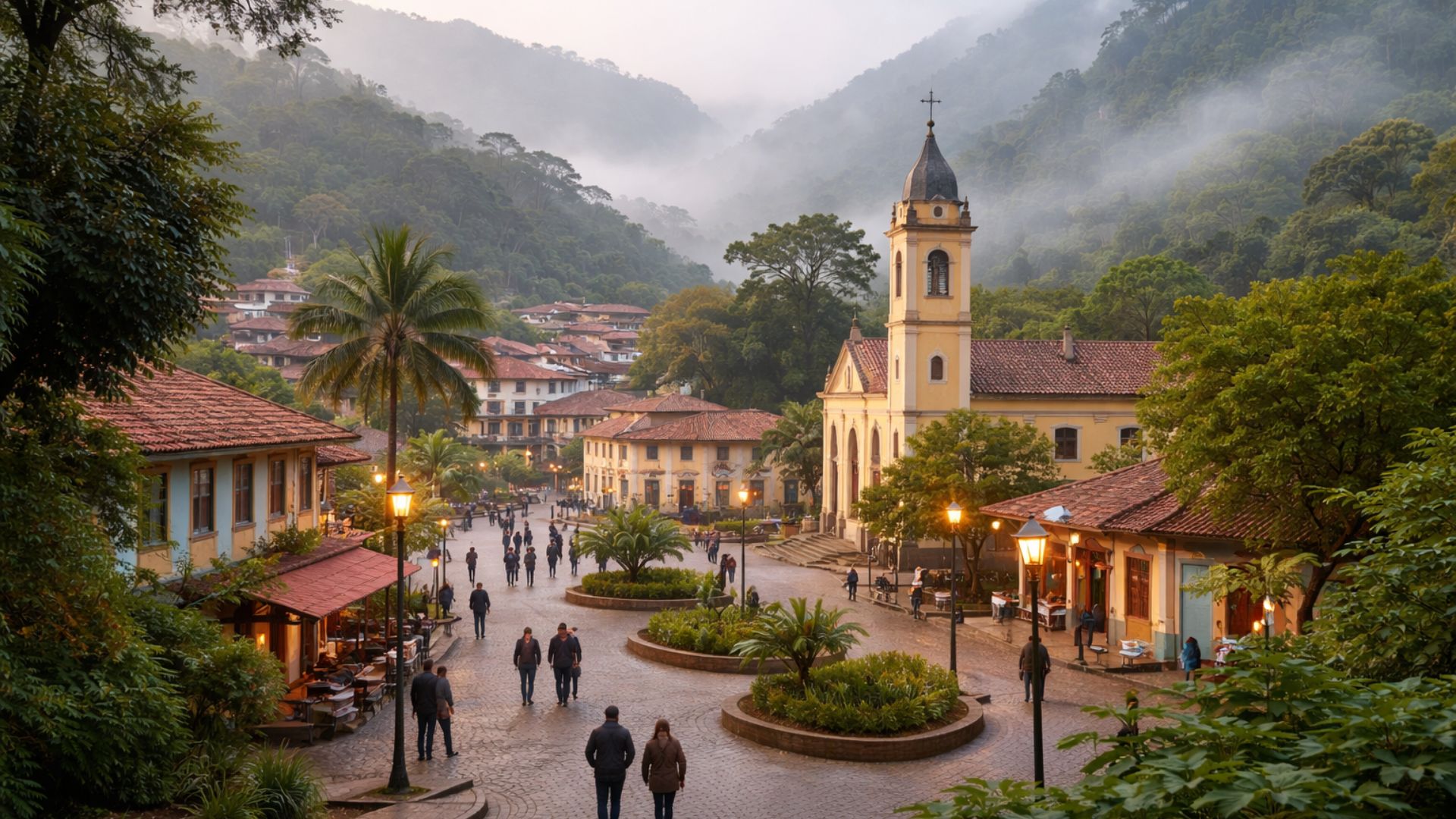


The Mountain City of Ceará Brings Together High Altitude, a Record of 13.3°C, a Jazz and Blues Festival, and a Location Within a State Conservation Unit, a Combination That Explains Why Guaramiranga Becomes a National Reference When the Topic is Cold in the Northeast.
Altitude, Cold, and an Uncommon Municipality in Ceará
Guaramiranga, a mountain municipality in Ceará, has characteristics that deviate from the thermal standard associated with the state: the headquarters is at 865.24 meters above sea level, the city has recorded 13.3°C in monitoring by the National Institute of Meteorology (Inmet), it hosts a traditional jazz and blues festival, and is part of the area covered by the Environmental Protection Area (APA) of Baturité Mountain, a conservation unit created by state decree.
This set of factors causes the municipality to frequently appear in news about cold in Ceará, while at the same time placing it on the cultural map of the state and in a region of officially recognized environmental importance.
The Record of 13.3°C and Its Impact in Local News
The record of 13.3°C in Guaramiranga was reported by Ceará’s news outlets based on information attributed to Inmet and is regarded as the lowest temperature ever observed in the historical monitoring series cited by these publications.
-
The Argentine government celebrates the lowest poverty rate in 7 years, but experts warn that the methodology has changed, real wages have fallen, unemployment has risen, and the number of people on the streets of Buenos Aires has increased by 57% since Milei took office.

-
7.8 magnitude earthquake in Indonesia frightens the population, triggers tsunami alert, and hits an island with over 200,000 inhabitants this Thursday.
-
Google will finally let you change that embarrassing Gmail address you created in your teenage years without losing any accounts, logins, or old emails: the feature is already available in the United States.

-
Heading to Brazil in a Bonanza F33 single-engine aircraft: a couple departs from Florida on a visual flight, makes technical stops in the Caribbean to refuel and organize paperwork, and begins the staged crossing until they reach the country.


The mark was associated with a November morning in 2022, during which the city drew attention again for low temperatures compared to local standards.

The same coverage also contextualized that, over the years, Guaramiranga tends to lead the lows in the state, in a scenario where downward variations are more noticeable in elevated areas.
Official Altitude and Its Effect on Daily Life
The official altitude of the municipality appears in public documents from the Institute of Research and Economic Strategy of Ceará (Ipece), in information compiled from the IBGE.
The municipal profile records 865.24 meters as the territorial measure of altitude and also details the geographic position and the straight-line distance to the capital.
In practice, this relief condition reflects in daily life: on colder days, jackets and blankets cease to be “travel items” and become part of local routines, especially in the early hours of the morning and at night, when the difference in thermal sensation becomes more noticeable.
APA of Baturité Mountain and Environmental Protection Around Guaramiranga
The fact that Guaramiranga is in a mountainous area is not restricted to its effect on the climate.
The city is part of a region recognized as a refuge for biodiversity and remnants of Atlantic Forest amidst the predominant Caatinga in the surroundings.
The APA of Baturité Mountain is presented by the Secretariat of the Environment of Ceará (Sema) as a sustainable use conservation unit, with mountain climate and temperature, and has legal creation certification through State Decree No. 20,956, of September 18, 1990, later amended by another decree in 2003.

Sema further informs the total area of the APA and its coverage by municipalities, which includes Guaramiranga among the involved localities.
This insertion in a conservation unit imposes a distinct dynamic on land occupation and use, as the APA aims to harmonize human presence with environmental protection.
In Baturité Mountain, protection is often associated with the preservation of landscapes, springs, and fragments of native vegetation, as well as tourist activities that rely on the appeal of the mountainous environment.
At the same time, the presence of environmental rules and management instruments, such as plans and zoning, tends to be a recurring theme in regional public policies, as it is an area where the pressure for occupation, tourism, and economic activities must engage with conservation.
Jazz & Blues Festival and the Cultural Weight of the Local Calendar
Tourism, in fact, is one of the most visible aspects of Guaramiranga for those outside the municipality.
The city is one of the most memorable destinations in Ceará when it comes to mountains, mild weather, and short travel from Fortaleza.
Within this context, the Jazz & Blues Festival appears as an element that helps turn seasonal attention into an organized flow of visitors.
The event has its own website and describes its proposal as a cultural alternative during the Carnival period, featuring concerts, workshops, and activities in Guaramiranga.

The festival’s implementation is also noted in institutional disclosures from state cultural agencies, which inform about editions and programming, reinforcing the event’s ties to the municipality and its role in Ceará’s cultural calendar.
Mountain Tourism, Thermal Contrast, and Public Interest
The combination of cooler weather and cultural events is often one of the driving forces of public interest, especially during periods when temperatures drop and the search for mountain destinations increases.
In the case of Guaramiranga, news reports about low temperatures tend to resonate due to contrast: in a state known for high temperatures throughout the year, the possibility of a morning with 13.3°C becomes easily shareable and quickly digestible information.
This type of information, when backed by meteorological sources, often gains traction on social media, radio, and portals, and becomes a topic among residents of warmer areas seeking a “break” from the heat.
In addition to the specific temperature record, local coverage of the 2022 episode also highlighted that Inmet maintains comparative records and that in other years, the municipality has been close to similar marks, with lows below 15°C on specific occasions.
This history helps explain why Guaramiranga remains a reference when the subject is cold in Ceará, without relying on a single event.
Still, the record of 13.3°C is the figure that encapsulates the phenomenon for the reader and is often the first reference cited when the municipality returns to the news.
Conservation Unit and the Landscape That Becomes News
Being in the APA of Baturité Mountain adds another layer of public interest, as it relates the “mountain climate” to an area officially recognized by the environmental management of the state.
In the institutional description of the conservation unit, Sema points out exuberance and biodiversity as attributes of the territory, in addition to associating the APA with strong tourism potential.
In practice, this means that the scenery appearing in photographs and videos of Guaramiranga, with denser vegetation and mountainous landscapes, is not just an aesthetic trait but part of a region with formal protection instruments and its own rules.
The municipality also appears in institutional pages of the city hall itself with data on altitude and geographic characterization, reinforcing the information that the city is at a high level compared to Ceará’s standards.
The convergence of official state sources, data compiled from IBGE, and journalistic coverage based on meteorological monitoring helps sustain, with public documentation, the central elements that make Guaramiranga be treated as a “cold city” in the state.
In daily life, this sum of factors tends to translate into a local identity marked by contrast: while a large part of Ceará deals with predominant heat, Guaramiranga is remembered for colder nights, for a highly visible musical event, and for being situated in an area of conservation that values natural attributes associated with the mountains.
In a country where regional variations often surprise even those who live in the same state, the municipality has become an example of how altitude, climate, culture, and environmental protection can intersect at the same address.
What other Brazilian city do you know that also breaks the expectation of the “typical” climate of its own region?


A primeira foto é fake.
A Serra da Ibiapaba também é uma região que oferece um clima frio e tem uma diversidade muito grande no turismo.
Guaramiranga não é a cidafe mais fria do Ceará. A mais fria fica proximo, é Aratuba. Um absurdo esta informação errada.