 Portuguese
  English
  Spanish
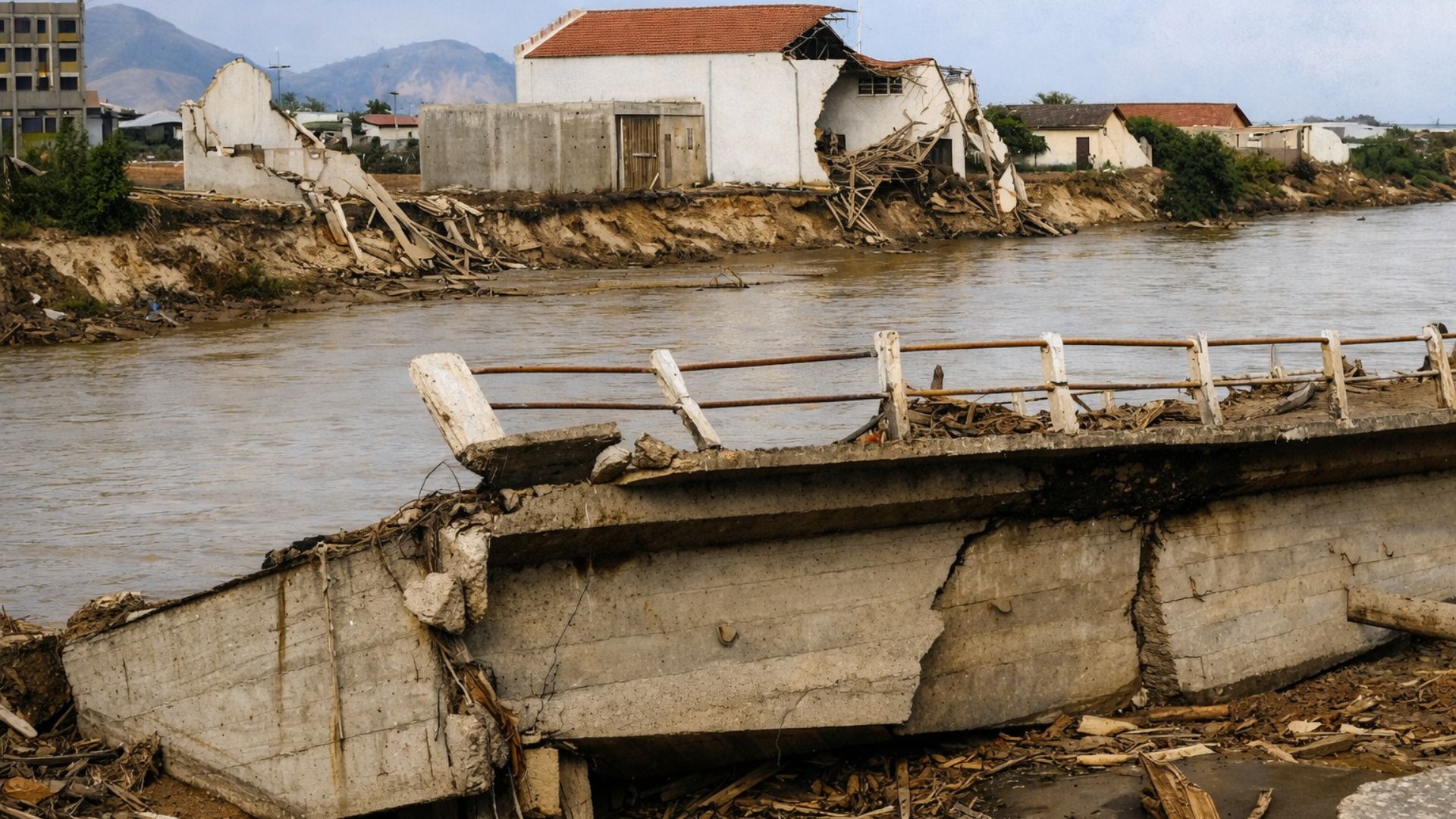
Extreme Rains Devastated Caraguatatuba in March 1967, Causing Landslides in Serra do Mar, Total Isolation of the Municipality and Hundreds of Deaths, in One of the Most Remarkable Episodes in the History of Natural Disasters in Brazil.
Caraguatatuba, on the North Coast of São Paulo, experienced a collapse caused by extreme rains on March 17 and 18, 1967, which triggered widespread landslides in Serra do Mar, flooding, and the isolation of the municipality, in an episode that marked the history of disasters in the country.
In two days, records and technical studies indicate a total of nearly 580 mm in 48 hours, an exceptional level for the region, sufficient to saturate the soil and turn slopes into corridors of mud, rocks, and trunks that advanced over neighborhoods, streets, and central areas.
Although the memory of the event is associated with “thousands,” the official victim numbers reported in later surveys remain in the hundreds, with 436 deaths frequently cited as the formal count, in addition to missing persons who were never fully quantified.
-
Friends have been building a small “town” for 30 years to grow old together, with compact houses, a common area, nature surrounding it, and a collective life project designed for friendship, coexistence, and simplicity.

-
This small town in Germany created its own currency 24 years ago, today it circulates millions per year, is accepted in over 300 stores, and the German government allowed all of this to happen under one condition.

-
Curitiba is shrinking and is expected to lose 97,000 residents by 2050, while inland cities in Paraná such as Sarandi, Araucária, and Toledo are experiencing accelerated growth that is changing the entire state’s map.

-
Tourists were poisoned on Everest in a million-dollar fraud scheme involving helicopters that diverted over $19 million and shocked international authorities.


At the same time, social impact estimates record about 3 thousand people without housing in a city that had a much smaller population than it does today, which elevated the humanitarian crisis and pressured the arrival of aid, hindered by interruptions in land connections and failures in basic services.

What Happened in Caraguatatuba in March 1967
The sequence of rains had already been intense during those days, but the worst phase consolidated between Friday and Saturday, when precipitation increased and the waterlogged ground lost stability, favoring the landslide of large volumes of material down the slopes.
A technical study compiling data from IPT records, for example, high daily values on March 17 and 18, and a total of 586 mm in 48 hours, a number very close to the rounded figure of 580 mm that became popular in historical reconstructions.
With the rupture of slopes, debris flows began to descend toward lower areas, carrying trees, rocks, and mud, hitting homes and altering the functioning of rivers and channels, in a scenario that complicated rescue efforts and the immediate assessment of the extent of the damage.
Technical reports and historical records also describe significant destruction in road accesses, including sections that today are part of the Tamoios Highway corridor, which contributed to Caraguatatuba being isolated and depending on support by sea and air.
Deaths, Homelessness, and the True Scale of the Tragedy

The divergence between what remained in popular memory and the official counts is a recurring feature in disasters with great destruction because entire families may have been affected simultaneously, documents can get lost, and in areas covered by mud, it is not always possible to locate all victims.
Still, widely cited surveys in public records and historical compilations indicate 436 deaths as the official number, while other academic works mention approximately 400 fatal victims based on newspaper records and consulted archives.
In social terms, the indication of around 3 thousand people who lost their homes helps to assess the disruption of local routines, with improvised shelters and the need for emergency assistance, in a context where municipal infrastructure was much more limited than it is today.
This was compounded by service interruptions, with reports of power outages for several days and issues with communication and supply, factors that tend to amplify health risks and the logistical complexity of rescue operations in isolated municipalities.
Impacts on Prevention and Civil Defense in São Paulo
In assessing the landslides and the extent of the impact, geotechnical experts at the time treated the episode as a landmark unprecedented in the country during that period, reinforcing the perception that extreme events required ongoing organization, not just improvised responses.
Over the years, this understanding became connected to institutional discussions that led the state government to formalize coordination structures, culminating in the creation of the State Civil Defense System, through Decree No. 7,550, of February 9, 1976.
This movement occurred during a period marked by other emergencies of great repercussions, such as fires in buildings in downtown São Paulo, which also expanded the debate on prevention, protocols, and the public authorities’ response capacity in the face of complex crises.
The Legacy of the 1967 Tragedy for Risk Areas
Almost six decades later, the episode is still remembered as a historical reference for discussions on hillside occupation, drainage, monitoring, and risk communication, especially in Serra do Mar areas where the combination of steep terrain and intense rain favors mass movement.
The challenge of accurately recording human and material losses in extreme events also remains current, as the quality of information influences compensations, reconstruction, urban planning, and, above all, the ability to prevent similar tragedies from occurring in new rainy seasons.
If Caraguatatuba became a symbol of a turning point in disaster management in São Paulo, what concrete measures are still lacking for vulnerable cities to be able to reduce losses before the next exceptional rain tests the limits of slopes and infrastructure?


-

-

6 pessoas reagiram a isso.