 Portuguese
  English
  Spanish
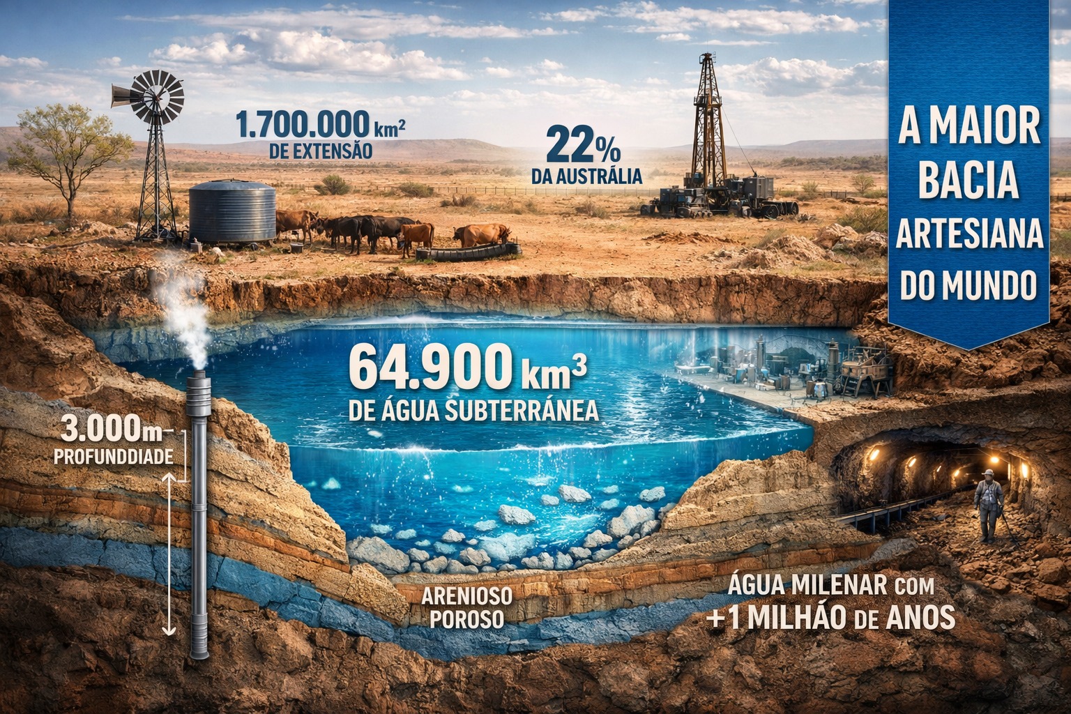
Underground System Reaches 3,000 Meters, Provides Freshwater to Arid Regions, Records Temperatures of 30 to 100 °C and Sustains Communities, Livestock, Industry, and Energy for Millennia in the Australian Interior
The Great Artesian Basin of Australia covers 1,700,000 km², reaches depths of up to 3,000 meters, contains about 64,900 km³ of groundwater, and sustains 22% of the continent in arid areas for millennia.
The Great Artesian Basin of Australia concentrates 1,700,000 km², reaches 3,000 meters in depth, and stores about 64,900 km³ of groundwater, providing fresh water to the arid interior, sustaining 22% of the continent, and shaping human occupation for millennia.
The Great Artesian Basin is considered the largest and deepest artesian basin in the world, serving as the main underground water reserve for extensive inner areas of Australia.
-
Friends have been building a small “town” for 30 years to grow old together, with compact houses, a common area, nature surrounding it, and a collective life project designed for friendship, coexistence, and simplicity.

-
This small town in Germany created its own currency 24 years ago, today it circulates millions per year, is accepted in over 300 stores, and the German government allowed all of this to happen under one condition.

-
Curitiba is shrinking and is expected to lose 97,000 residents by 2050, while inland cities in Paraná such as Sarandi, Araucária, and Toledo are experiencing accelerated growth that is changing the entire state’s map.

-
Tourists were poisoned on Everest in a million-dollar fraud scheme involving helicopters that diverted over $19 million and shocked international authorities.

Its extent covers approximately 22% of the Australian continent, encompassing large parts of Queensland, the southeast of the Northern Territory, the northeast of South Australia, and the north of New South Wales.
At some points, the aquifer system reaches depths of up to 3,000 meters, a condition that directly influences internal pressure, the natural flow of water, and its thermal characteristics.
Water temperatures vary between 30 and 100 °C, reflecting the depth of the aquifer layers and allowing applications that exceed human and agricultural consumption.
Estimates suggest that the basin contains around 64,900 km³ of groundwater, primarily stored in deep formations of porous sandstone.

Geological Formation and Dynamics of Groundwater
Water is retained in sandstones formed during the Triassic, Jurassic, and early Cretaceous periods, subsequently sealed by marine sedimentary rocks.
This sealing created a confined aquifer system, where internal pressure allows water to flow naturally when drilled under certain conditions.
Recharge occurs mainly in elevated areas on the eastern edge, located in Queensland and New South Wales, where infiltration is more significant.
From these areas, water flows slowly to the south and west, traveling long distances over geological timescales.
In arid regions of central Australia, recharge is lower along the western margin, with estimated flow rates between one and five meters per year.
Carbon-14 and chlorine-36 analyses indicate ages ranging from thousands of years in recharge zones to nearly 2 million years in the southwest.
Human Use, Occupation, and Historical Impacts
Before European colonization, water naturally emerged in mound springs, supporting Aboriginal communities, trade routes, and endemic aquatic invertebrate species.
These springs played a central role in traditional occupation, serving as permanent points of survival in extremely arid environments.
After 1878, when a shallow well produced flowing water near Bourke, the basin facilitated the settlement of vast inland areas that were previously inaccessible.
The availability of water allowed the expansion of livestock, irrigation, and domestic use, establishing settlements far from permanent rivers.
By 1915, there were about 1,500 wells supplying approximately 2,000 megaliters per day, a volume that has now dropped to about 1,500 megaliters daily.

Management, Environmental Risks, and Specific Uses of the Aquifer
Currently, there are just under 2,000 free-flowing wells and more than 9,000 wells that require continuous pumping for operation.
Many of these wells remain abandoned or lack proper regulation, contributing to pressure loss and significant water waste.
Total extraction significantly exceeds natural recharge, causing a decline in internal pressure and the disappearance of various historical springs.
The basin also supplies the Olympic Dam mine, authorized to extract up to 42 megaliters per day, in addition to specific industrial uses.
In Birdsville, a geothermal plant operates with a 1.2 km deep well, utilizing water at 98 °C for local power generation.
Integrated management involves state, territorial, and federal governments, coordinated by the Great Artesian Basin Committee, responsible for a strategic plan published in 2020.
Environmental concerns include risks associated with coal gas extraction, hydraulic fracturing, and carbon storage, practices prohibited in the basin since May 2024.
With information from Wikipedia.


-

-

-

-

-

-

118 pessoas reagiram a isso.