 Portuguese
  English
  Spanish
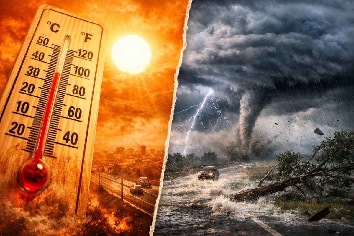
Forecast Indicates Peak of Heat Wave This Thursday (19), Driven by a Warm Air Mass Between Paraguay and Northern Argentina, with Conditions Indicated by the EFI. Subsequently, Starting Friday (20), a Cold Front Advances and May Bring Storms, Up to 100 mm, Winds of 100 km/h and Hail.
The day starts with a furnace-like feeling in parts of the South and moves towards a rapid change scenario because the peak of heat this Thursday (19) opens space for instability and storms shortly thereafter, with potential for disruptions in different regions.
The combined reading of forecasts and alerts shows two very distinct moments: first, temperatures that may exceed 40°C; then, the arrival of a frontal system on Friday (20), with a risk of heavy rain, strong gusts, and hail, as well as impacts such as power outages and flooding.
The Peak of Heat and Why It “Stretches” the Risk of Sudden Change
The rise in temperatures is associated with the presence of a warm air mass located over Paraguay and northern Argentina, favoring the maintenance of very warm air in part of Brazil throughout this Thursday.
-
Motorola launched the Signature with a gold seal from DxOMark, tying with the iPhone 17 Pro in camera performance, Snapdragon 8 Gen 5 that surpassed 3 million in benchmarks, and a zoom that impresses even at night.

-
Satellites reveal beneath the Sahara a giant river buried for thousands of kilometers: study shows that the largest hot desert on the planet was once traversed by a river system comparable to the largest on Earth.

-
Scientists have captured something never seen in space: newly born stars are creating gigantic rings of light a thousand times larger than the distance between the Earth and the Sun, and this changes everything we knew about stellar birth.

-
Geologists find traces of a continent that disappeared 155 million years ago after separating from Australia and reveal that it did not sink, but broke into fragments scattered across Southeast Asia.

This type of configuration tends to increase thermal discomfort and prolong periods of persistent heat, especially where there is less cloudiness and more heating during the day.
Furthermore, the Extreme Forecast Index (EFI) indicates the possibility of very unusual or extreme weather conditions in most of the country throughout the day.
When the atmosphere becomes exceptionally heated, any change in wind and humidity patterns tends to have quicker repercussions, which helps explain why attention shifts from extreme heat to the chance of storms as the cold front begins to organize and advance.
Where the Heat Should Be Most Intense This Thursday (19)
The expectation is for more intense heat in Santa Catarina, especially in the western region of the state, where thermometers may exceed 40°C.
This behavior is not limited to a single state: the projection also mentions other areas with a higher probability of elevated temperatures, reinforcing that the peak of heat spreads across different regions of the territory.
Among the mentioned regions are the Northwest of Rio Grande do Sul (especially Northwest Rio Grande do Sul), the Northwest, West, and Southwest of Paraná, and in São Paulo, the area of Presidente Prudente.
Also included in the map is Mato Grosso do Sul, in most of the state (except for the central-north), and Mato Grosso, especially in the Southwest, Central-South, and Southeast.
This regional breakdown matters because it defines where heat concentrates first and where the transition to storms may be felt more after, as instability advances.
The Turn Starting Friday (20): Cold Front on the Radar and Storms Taking Shape
Starting Friday (20), the indicated trend is for a relief in temperatures in parts of Brazil with the advance of a cold front. Nonetheless, heat may persist in areas like Mato Grosso do Sul, northern Paraná, western São Paulo, and southern Mato Grosso, which creates a relevant contrast: very hot air on one side and a change of pattern on the other.
It is exactly in this contrast scenario that storms may intensify. With the arrival of the frontal system, the chance of heavier and more organized rains increases, accompanied by gusts of wind and episodes of hail.
The critical point is not just to rain, but the combination of intense rain in a short period with strong winds, which increases the risk of falling trees, power outages, and problems in areas more vulnerable to flooding.
What Do “Up to 100 mm” and “Winds of 100 km/h” Mean in Everyday Impact
The Inmet alert indicates the possibility of intense rainfall of up to 100 millimeters per day and wind gusts of 100 km/h on Friday (20), with Santa Catarina highlighted and other states also included in the warning.
Among the areas mentioned are Santa Catarina, Rio Grande do Sul, Mato Grosso do Sul, and Paraná, indicating a corridor of instability that may affect urban routines and activities in the field.
In practice, high volumes of rain in a short time raise the risk of flooding and flash floods in critical points, especially where drainage is limited. Meanwhile, very strong gusts can bring down branches, trees, and more fragile structures, as well as cause power outages, a typical effect when wind and storms combine.
Hail, in its turn, tends to be localized but can cause damage to roofs, vehicles, and crops, reinforcing why storms demand attention even when they do not uniformly affect the entire state.
Associated Risks and Why Attention Needs to Be Technical, Not Alarmist
The main risks associated with the mentioned storms include power outages, hail, damage to crops, falling trees, and flooding.
It is a set of impacts that varies according to the neighborhood, topography, infrastructure, and even the time when the heaviest rain occurs, which is why the perception of “normalcy” can be very different between nearby cities.
At the same time, it is not a scenario for panic, but rather for careful risk assessment: extreme heat may continue in some areas even with the cold front advancing, and storms may distribute unevenly.
In such episodes, the key is to understand that storms are not just “heavy rain,” but a package of effects with the potential for disruption, especially when wind and hail factor into the equation.
Thursday (19) concentrates the peak of heat in parts of the South and other states, with a chance of exceeding 40°C in Santa Catarina, and the sequence of the scenario points to the turn on Friday (20), when the cold front may favor storms with intense rain, strong winds, and hail risk, along with the possibility of power outages and flooding.
In your city, what tends to weigh more when storms arrive: power outages, flooding, wind knocking down trees, or hail damaging roofs and cars? Have you noticed if the worst happens right after very hot days, or does the change catch everyone by surprise?


-

-

-

3 pessoas reagiram a isso.