 Portuguese
  English
  Spanish
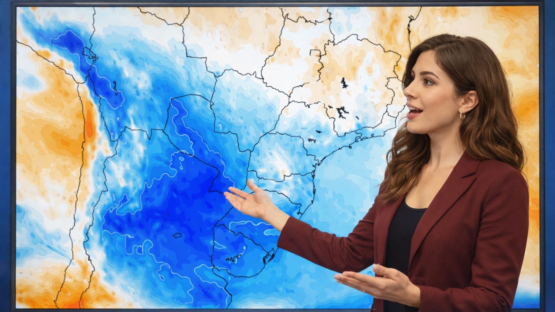
Weather change advances through the South of Brazil and begins transition after persistent heat, with gradual decrease in temperatures and forecast of colder mornings throughout the week, although there is still influence of warm air in some regions.
The arrival of a cold air mass in the South of Brazil begins to influence the weather this Monday, after a Sunday still marked by heat in various regions, gradually ending a prolonged period of high temperatures that has extended since March with records well above the historical average.
According to an analysis by MetSul Meteorology, the change in the atmospheric pattern begins to consolidate with the action of systems between Argentina and Uruguay, which favor the advance of cold air towards Brazilian territory, albeit initially in a more limited way.
Even with the ongoing transition, the heat does not disappear immediately, as part of Rio Grande do Sul still remains under the influence of warm air, especially in the Northwest regions, where temperatures remain high at the beginning of the week.
-
Young people are begging to join the Army due to a shortage of jobs as unemployment hits 16%, with nearly 1 million out of work, military applications soar, and the armed forces shrink to their lowest level in decades in the United Kingdom.

-
Young wheelchair delivery person goes viral at 19 by making up to 6 deliveries a day within a 1 km radius, living alone in SC, starting on March 5, and receiving a tricycle that can multiply income.

-
With a production of 3000 kg per day, a dried pork factory in Taiwan uses few machines, slow cooking, and manual labor to maintain quality standards in the food industry and flavors valued by consumers.

-
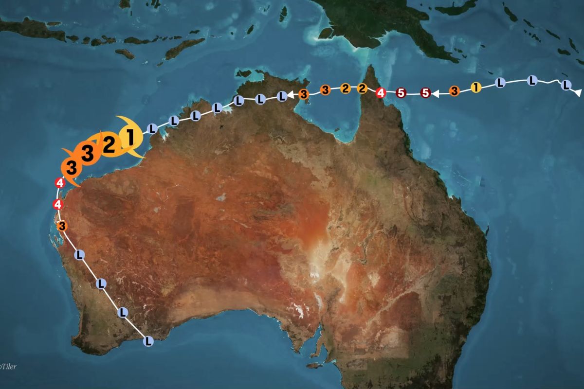
Cyclone Narelle swept through northern Australia with winds of 200 kilometers per hour, destroying crops, homes, and marine life, but what came next was even more surprising: an entire community took to the streets to help strangers.
The recent scenario in the state highlights the intensity of the recorded heat, with the municipality of São Luiz Gonzaga, in the Missions region, accumulating nine consecutive days with maximums above 30°C, constituting an unusual sequence for the period.
Data from the National Institute of Meteorology show that, throughout this sequence, thermometers reached 30.5°C on March 25, progressively rising to 37.2°C on March 29, with maintenance of high levels in the following days, reinforcing the persistent heat pattern.
This abnormal thermal behavior stood out for its duration and intensity, with temperatures frequently above the climatological average, impacting both the thermal sensation and environmental conditions in different regions of the state.
Initial advance of cold air is still irregular in the state
The initial incursion of cold air, which began to manifest on Sunday, advances this Monday in a more noticeable way in areas of the South and East of Rio Grande do Sul, where a gradual decrease in temperatures is already observed throughout the day.
Meanwhile, regions in the West and Northwest still face significant heat, highlighting a thermal contrast within the state itself, resulting from the partial action of the cold air mass at this first moment.
Between this Monday and Tuesday, the forecast indicates that warm air can still reorganize in part of the gaucho territory, maintaining afternoons of moderate to intense heat in some localities, especially inland.
This persistence is associated with the presence of a low-pressure area between Argentina and Uruguay, which contributes to the circulation of warm air before a broader change in the atmospheric pattern.
Weather change gains strength from Wednesday
A more consistent alteration in climatic conditions is expected from Wednesday, when the deepening of the low pressure in the Rio de la Plata region intensifies the movement of cold air towards the South of Brazil.
At this moment, the cold air mass begins to act in a more comprehensive and continuous way, reaching different regions of Rio Grande do Sul and establishing a more typical autumn pattern, with a more widespread reduction in temperatures.
The change represents the effective end of the prolonged heat sequence, replaced by milder days and mornings with a feeling of cold in various cities, especially in the second half of the week.
Temperature drop will be significant, even without intense cold
Although it is not a cold air mass of great intensity, meteorological models indicate a significant drop in thermometers, especially in the mornings, when cooling tends to be more pronounced.
Projections indicate minimums between 10°C and 13°C in most of Rio Grande do Sul by the end of the week, while in the metropolitan region of Porto Alegre, values should be close to or slightly below 15°C.
This scenario marks a significant change compared to previous days, when maximums frequently exceeded 35°C, highlighting a significant thermal variation in a short period of time.
Even though the cold is not extreme, the difference in temperatures will be enough to characterize an environment more compatible with autumn, with a direct impact on the population’s routine and thermal perception throughout the day.
Effects outside the South include rain and moderate variation
Outside the South region, the effects of the cold air mass tend to be more limited, with a greater impact concentrated on the change of instability conditions rather than on sharp temperature drops.
In the state of São Paulo, for example, the forecast indicates a more discreet reduction in temperatures, especially in the South and East of the São Paulo territory, with no expectation of very low minimums.
At the same time, the interaction between the advance of cold air and other atmospheric systems should favor the formation of areas of instability over the Midwest and Southeast, increasing the occurrence of rain in the coming days.
Volumes may exceed the expected average for April in some localities, which contributes to the decrease in temperatures during the day, although nights remain relatively mild in these regions.
The thermal drop outside the South will be more associated with the presence of cloudiness and precipitation than with the direct influence of cold air, maintaining a distinct pattern from that observed in the southern states.


Seja o primeiro a reagir!