 Portuguese
  English
  Spanish
The cold front advancing through southern Brazil intensifies on this Monday (23) with storms, strong winds, and rain of up to 100 mm that may cause flooding and disruptions in Rio Grande do Sul, Santa Catarina, and Paraná
The cold front that has been moving through southern Brazil since the weekend gains strength on this Monday (23) and puts three states on alert for heavy rain. The forecast indicates accumulations that may reach 100 mm in just a few hours, a volume sufficient to cause flooding, power outages, and river overflows in more vulnerable areas. Rio Grande do Sul, Santa Catarina, and Paraná are expected to face the most critical day of this cold front passage.
The scenario requires heightened attention. According to information from Meteored, a new, more intense system is forming and reinforcing the instabilities that have already been affecting the region. The rain caused by the cold front intensifies throughout the day and spreads across the three southern states, accompanied by gusts of wind, electrical discharges, and the possibility of hail. For those living in risk areas or needing to travel, the alert is clear: Monday requires caution.
Where the cold front will cause more rain
The highest volumes of rain are expected to concentrate in Rio Grande do Sul, especially in regions near the border with Uruguay. In these areas, the accumulations caused by the cold front may reach around 100 mm, which increases the risk of river overflow, flooding, and landslides.
-
In a flooded well, archaeologists found a 1,700-year-old Roman egg that still contains clear and yolk intact inside the very thin shell.

-
Something is happening around the Earth: Inside the huge explosion of fireballs in 2026

-
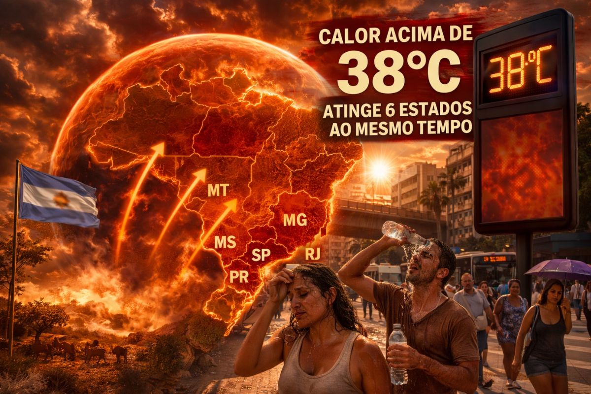
A hot air bubble coming from Argentina expands over Brazil, causing thermometers to exceed 38 degrees with a thermal sensation of 40 degrees in late March, affecting 6 states at once.
-
The radish leaf that almost everyone throws away has more polyphenols, flavonoids, and fiber than the consumed root, and a 2025 study showed that the leaf contains compounds that protect the intestine, combat inflammation, and may inhibit the growth of cancer cells.


This is the point on the map where the combination of rainfall volume and terrain vulnerability creates the most dangerous situation.
In Santa Catarina and Paraná, the rain brought by the cold front also appears widely, mainly between the afternoon and evening of Monday.
The volumes are likely to be lower than in Rio Grande do Sul, but still sufficient to cause urban disruptions such as flooding points, slow traffic, and interruptions in power supply. The cold front spares none of the three southern states this Monday.
Storms, winds, and hail accompany the cold front
The heavy rain does not come alone. The cold front brings with it a package of instabilities that includes gusts of wind with the potential to knock down trees and poles, frequent electrical discharges, and the possibility of hail in isolated spots.
This combination makes Monday especially dangerous for those needing to move in open areas or on roads in the southern region.
This type of event is expected during the transition between seasons when air masses of different temperatures collide and generate intense atmospheric instability.
What stands out in this specific cold front is the predicted intensity: 100 mm in just a few hours is a volume that even cities with good drainage infrastructure struggle to absorb. The risk of flooding is real and is not limited to historically flood-prone areas.
Care for those who need to leave home on Monday
The Civil Defense of the three states maintains an active alert for the passage of the cold front.
For those needing to travel during the most intense storms, the guidelines are straightforward: avoid traveling through flooded areas, keep a distance from poles and trees on windy days, and follow official alerts in real-time.
Inside the house, it is advisable to pay extra attention to loose objects in external areas that may be thrown by the force of the wind.
In case of a power outage caused by the cold front, the recommendation is not to attempt repairs on your own and to contact the utility company. For those living on slopes or near rivers that tend to overflow, the time to prepare is before the rain arrives, not during.
How the next days will be after the cold front
The trend is that, after the passage of the cold front, the weather will begin to stabilize in Rio Grande do Sul as early as Tuesday. In Santa Catarina and Paraná, there may still be isolated showers, but without the intensity expected for Monday.
The peak of risk is concentrated precisely on this Monday, when the system reaches its maximum strength over the three states.
Episodes of intense rain like this, caused by cold fronts during the transition between seasons, have become more frequent in recent years.
The unstable weather of the period between summer and autumn favors the formation of more aggressive systems, and the forecast for the coming weeks still includes the possibility of new cold fronts hitting southern Brazil. Those living in the region need to maintain the habit of checking the weather forecast daily.
This cold front on Monday is the most intense event of the week in southern Brazil. With 100 mm of rain expected in just a few hours, flooding, strong winds, and power outages, the day calls for maximum attention in Rio Grande do Sul, Santa Catarina, and Paraná. The rain will pass, but the damage from not preparing can last much longer.
How is the weather in your city? Have you felt the effects of the cold front? Share in the comments and let those living in the South know to stay alert.


Seja o primeiro a reagir!