 Portuguese
  English
  Spanish
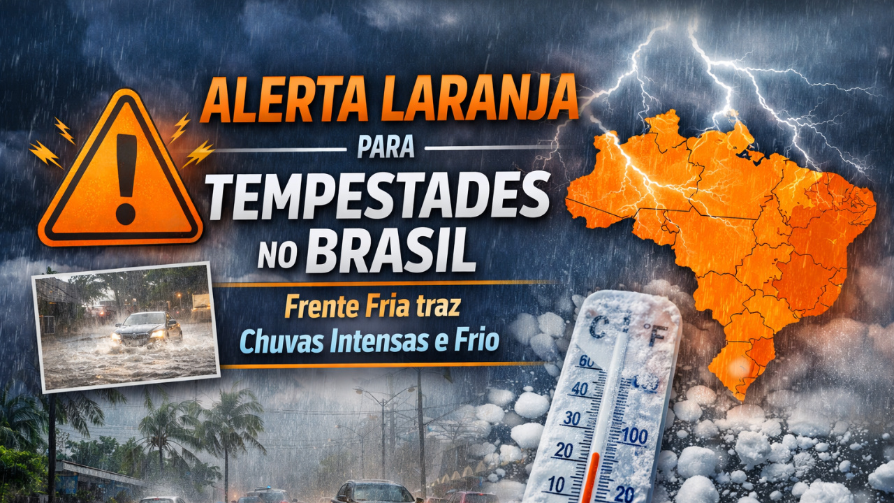
Orange Alert Forecasts Heavy Rains, Cold Front, and Temperature Drop in Much of Brazil After Carnival.
The post-Carnival period begins with heavy rains and temperature drop in much of the country, according to a notice from the National Institute of Meteorology.
The agency issued a orange alert for this Thursday (19), indicating a risk of storms in the states of the South, Southeast, North, and Northeast.
The change in weather occurs due to the arrival of a cold front, which causes instability, strong winds, and the possibility of hail.
-
Friends have been building a small “town” for 30 years to grow old together, with compact houses, a common area, nature surrounding it, and a collective life project designed for friendship, coexistence, and simplicity.

-
This small town in Germany created its own currency 24 years ago, today it circulates millions per year, is accepted in over 300 stores, and the German government allowed all of this to happen under one condition.

-
Curitiba is shrinking and is expected to lose 97,000 residents by 2050, while inland cities in Paraná such as Sarandi, Araucária, and Toledo are experiencing accelerated growth that is changing the entire state’s map.

-
Tourists were poisoned on Everest in a million-dollar fraud scheme involving helicopters that diverted over $19 million and shocked international authorities.


In addition, the scenario is expected to repeat on Friday (20), keeping rainy weather in various regions.
Orange Alert Indicates Risk of Storms in Brazil
The communication from the National Institute of Meteorology classifies the phenomenon as having intermediate severity, which requires public attention.
The orange alert points to potential danger from storms in Brazil, especially in Minas Gerais, São Paulo, Paraná, Santa Catarina, Amazonas, Maranhão, and Rio Grande do Sul.
In these areas, forecasts indicate significant rainfall accumulations.
Volumes may reach at least 50 millimeters per day, with peaks of up to 100 millimeters in some locations.
Additionally, winds are expected to gust up to 60 km/h, increasing the risk of falling branches, flooding, and urban disruptions.
Cold Front Causes Temperature Drop After Heat Wave
After several days of heat during Carnival, the arrival of the cold front changes the climate pattern.
As a result, thermometers are expected to register a temperature drop in nearly all states.
This change will be more noticeable in the capitals of the South and Southeast regions, which start the day with an overcast sky and rain showers throughout.
Therefore, the contrast with the recent heat should be felt mainly in the mornings and evenings, when the weather will be cooler.
Heavy Rains Affect Nearly the Entire Country
The forecast indicates heavy rains across almost the entire national territory.
The exceptions are areas in southern Bahia, Goiás, Espírito Santo, and the northern part of Minas Gerais, where instability is expected to be lesser.
Still, the rest of the country remains under the influence of storms in Brazil, with the possibility of thunderstorms and significant accumulations.
In some places, there is a risk of hail, especially in the South and Southeast regions.
Friday Maintains Instability Scenario
For Friday (20), the weather pattern is not expected to change significantly.
The trend is for a continuation of heavy rains, with many clouds and showers throughout the day.
On the other hand, the temperature drop is expected to persist, signaling the end of the heat wave recorded during Carnival.
This behavior reinforces the influence of the cold front over the country.
What the Orange Alert Means
The orange level represents an intermediate stage of severity.
This means there is a risk of dangerous weather phenomena, although not extreme.
Nonetheless, the National Institute of Meteorology recommends vigilance, especially in areas with a history of flooding and landslides.
The guidance is to avoid open areas during storms, not to seek shelter under trees, and to follow official announcements.
Expected Impacts in Cities
In urban areas, the main effect of the heavy rains may be an increase in flooding points.
Additionally, strong winds can cause power outages and traffic disruptions.
Meanwhile, the temperature drop is expected to provide thermal relief after days of heat, but it also requires adjustments in routine.
The population should prepare for rapid weather changes, common during the passage of a cold front.
Monitoring Continues in the Coming Days
Meteorologists continue to monitor the evolution of storms in Brazil.
As the atmospheric system is still in motion, new alerts may be issued.
Therefore, following updates from the National Institute of Meteorology is essential to reduce risks.
The scenario requires heightened attention, especially in regions with forecasts of high rainfall volumes and intense winds.
The combination of orange alert, heavy rains, cold front, and temperature drop marks the transition of weather after Carnival, signaling more unstable days in much of the country.
See more at: Post-Carnival Should Be Marked by Heavy Rains and Temperature Drop


-

Uma pessoa reagiu a isso.