 Portuguese
  English
  Spanish
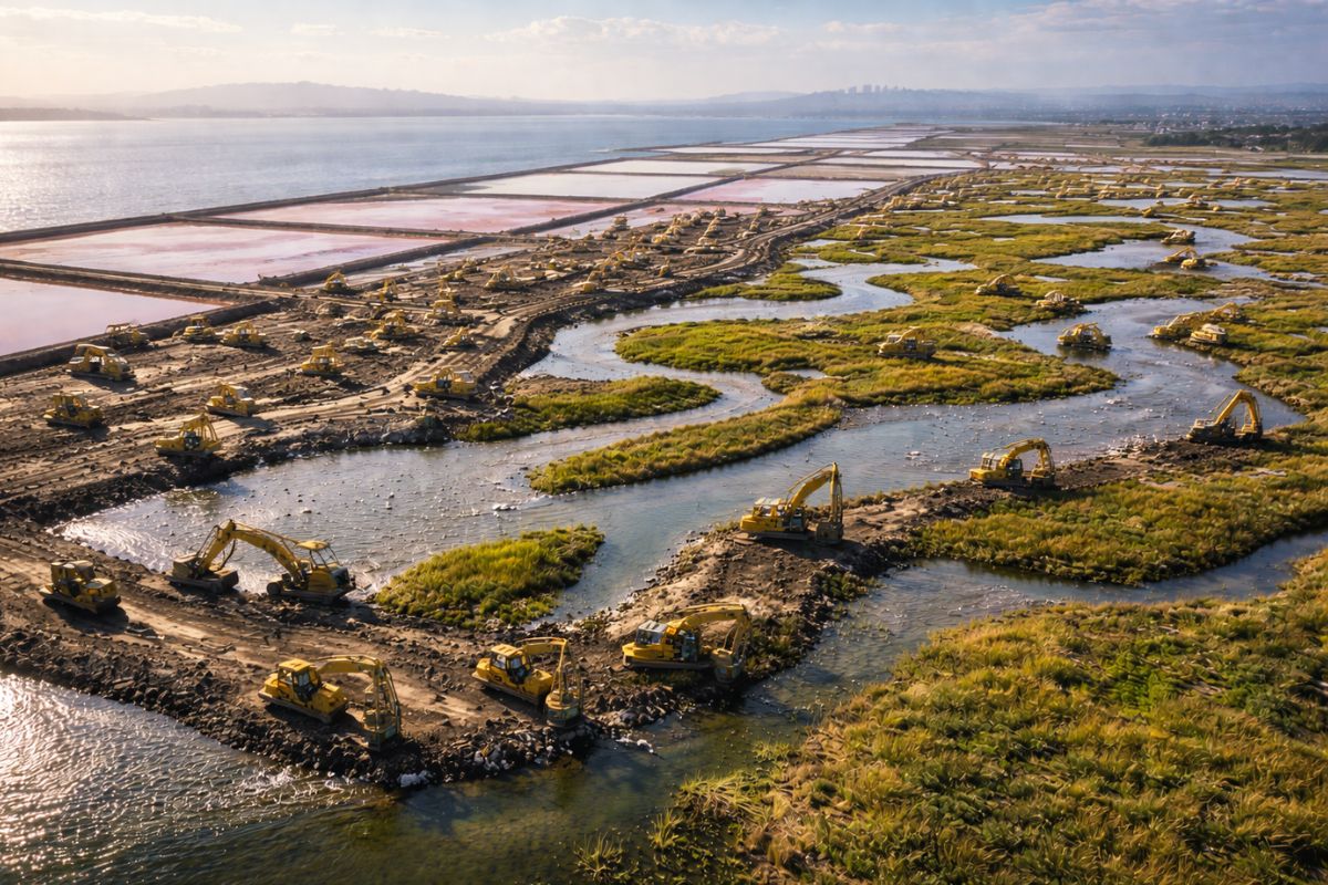
In California, the 50-Year Project Reverts 15,100 Acres of Industrial Salinas from the San Francisco Bay into Wetlands, Trails, and Internal Dikes, Trying to Reduce Floods, Improve Water Quality, and Create an Adaptive Infrastructure Capable of Responding to Sea Level Rise in the Coming Decades Securely.
In California, one of the most artificial landscapes along the southern edge of the San Francisco Bay is being redesigned to serve a purpose almost opposite to what it used to be. Where there were once industrial salinas, the plan is now to make way for coastal wetlands, reorganize lagoons, strengthen internal lines of protection, and try to reduce floods in an increasingly pressured scenario by sea level rise.
The project operates on a rare scale: 15,100 acres, about 6,110 hectares, treated as a long transition between engineering, restoration, and land defense. The ambition is not just to recover a degraded environment, but to convert an old industrial infrastructure into a new living infrastructure, capable of retaining water, softening tides, and reorganizing the relationship between the coast and inland communities.
How California Transformed Salinas into a Half-Century Project

The South Bay Salt Ponds Restoration Project is described as the largest coastal wetland restoration project on the West Coast.
-
Dozens of Chinese research ships are discreetly mapping the ocean floor in three oceans – and naval analysts see a military pattern.
-
The winter of 2026 in Brazil will not be what you expect: meteorologists warn that the season will be warm and rainy at the same time due to the advance of El Niño, which is already warming the Pacific and changing the climate of the entire country.

-
For the first time, humanoid robots will compete in a full half-marathon without any human assistance in Beijing, with over 100 teams from China registering machines that need to complete the course with autonomous navigation on two legs.

-
Submarine cables installed to transmit the internet now also help scientists detect earthquakes.
When completed, it will have transformed 15,100 acres of old industrial salinas from the San Francisco Bay into a mosaic of coastal wetlands and other associated environments. This outcome did not happen by chance.
The bay has lost about 85% of its historical marshes due to landfills and other alterations, which has reduced water quality and increased the risk of local floods.
The acquisition of the area occurred in 2003, under the leadership of Senator Dianne Feinstein, when the South Bay salt ponds were purchased from Cargill Inc. with funds from federal and state agencies and private foundations.
The transfer of this property was treated as the largest individual acquisition within a broader campaign to restore 40,000 acres of lost coastal wetlands in the San Francisco Bay.
What was at stake there was not just the ownership of the land but the possibility of redesigning an entire coastal edge.
After the purchase, the project began to follow a Restoration Plan adopted in 2008, following four years of work with representatives from agencies, scientists, stakeholders, and members of the public.
This plan organizes three permanent axes: restoration, recreation, and protection. In other words, California did not treat these former salinas merely as environmental liability but as strategic area to combine public access, flood control, and gradual response to sea level rise.
Since then, thousands of acres have been reopened for new salt marshes to form, hundreds of acres of lagoons have been revitalized, and several kilometers of trails have been constructed.
The progress is presented as phased and continuous, precisely because the scale requires time. Transforming an industrial landscape into living infrastructure is not a one-cycle job, but a decades-long process in which water, sediment, and engineering need to start communicating again.
Why Wetlands Have Come to Be Treated as Coastal Protection

The strength of the project lies in a shift in logic. Instead of relying solely on rigid structures, the proposal seeks to make wetlands a part of the coastal protection system.
This is clearly seen in the axis called “Protection,” which centers on managing the risks of floods caused by tides, storms, and sea level rise.
The explicit goal is to ensure that risks to neighboring communities and infrastructures do not increase as a result of the restoration.
To achieve this, the plan calls for a cohesive line of internal dikes along the coast or other forms of flood risk management in the areas situated within the project.
Options include raising existing dikes, filling in lands, or building new dikes. In some sections, the restoration of wetlands itself will be delayed until these protective works are ready.
This shows that the project does not treat restoration and defense as separate themes, but as parts of the same spatial design.
In practice, the old industrial logic, based on the strict compartmentalization of salinas, is being replaced by a hybrid logic.
Part of the protection still requires conventional works, but the project bets that restored wetlands can absorb water energy, reduce pressure on hard structures, and offer a more elastic response to the advance of sea level rise.
In a low and vulnerable territory, this combination ceases to be optional and becomes a necessity.
The case of Alviso helps understand this articulation. Plans for controlling floods in this area advance through a dike on the shoreline of San Jose Bay, integrated with the South Bay Shoreline Project of the San Francisco Bay.
In other words, the effort is not limited to the interior of the old salinas. It is connected to a larger network of coastal containment that seeks to protect neighborhoods, infrastructure, and urban areas against a backdrop of more aggressive tides and prolonged sea level rise.
What the Second Phase Tries to Accelerate on the Edge of the San Francisco Bay
The project states that it is in the midst of the second construction phase. In this stage, scheduled to start in 2018, the priority shifts mainly to the restoration of salt marshes.
The justification is straightforward: modeling conducted so far indicates that accelerating the formation of these wetlands can help create a more effective protection against sea level rise, precisely because these environments can function as buffers between the open bay and dry land.
This phase also includes the use of fill to create higher areas in wetlands and lagoons, in order to deal with flooding, high tides, and the very sea level rise.
The detail is important because it shows that the project is not simply “returning nature” to the land.
It is designing levels, elevations, and surfaces so that the new landscape functions in future scenarios, when water behavior will be more extreme than in the recent past.
At the same time, the second phase maintains the goal of expanding public access with trails, observation platforms, interpretative stations, and access to waterways, including ramps for non-motorized vessels.
The presence of these facilities is not peripheral. The project aims to open the shoreline of the San Francisco Bay to millions of residents and visitors, as long as this is compatible with the dynamics of wetlands and water management.
This opening reinforces the political nature of the work. California is not just recovering a degraded edge; it is defining how it will be used, observed, and defended in the coming decades. And this explains why the timeline is 50 years.
An intervention of this scale needs to absorb uncertainty, test solutions, correct paths, and accept that the coastline will not remain static while the project progresses.
Science, Adaptive Management, and Decisions That Change with Experience
One of the most important aspects of the project is the explicit use of so-called adaptive management.
The coordination itself recognizes that, given the natural and social complexity of the San Francisco Bay, it is not possible to know in advance what the best combination is between the rapid construction of wetlands, flood protection, balance of public uses, and response to sea level rise.
Instead of waiting for total certainty, the adopted strategy was to act and measure at the same time.
The project’s Scientific Program exists precisely for this: to provide a technical basis for management decisions, adjust restoration goals, and measure the success of the interventions. In this model, each action is treated as an experiment.
After execution, scientists and managers evaluate effectiveness and impact, and the results can lead to changes in goals, redefinition of the problem, or alteration of future actions.
It is a way to manage uncertainty without paralyzing the work.
This choice is consistent with the size of the challenge. Reconfiguring old industrial salinas into coastal wetlands involves hydrology, sediments, tides, infrastructure, public access, and urban protection.
If a solution fails or produces a different effect than expected, the project needs to be able to correct its course. In a coast pressured by sea level rise, insisting on a wrong answer can cost decades lost and increase the risk of floods.
The participatory component also enters this system. More than 40 meetings, workshops, and participatory sessions were held to develop the long-term plan, and a forum with about 25 interested entities meets regularly to analyze projects and offer contributions.
In practice, this means that California is trying to build this corridor of wetlands and coastal protection cooperatively, even though the center of the debate remains technical: how to transform an industrial landscape into a functional and lasting coastal defense.


-

Uma pessoa reagiu a isso.