 Portuguese
  English
  Spanish
Florida Is Often Remembered For Beaches, Heat, And Urban Expansion, But The Population Distribution Reveals A Different Portrait: The North Holds Only 18% Of The State’s Residents Because It Carries Geographical Limitations, Weaker Infrastructure, Lower Tourist Appeal, And A Historical Trajectory That Concentrated Wealth, Migration, And Opportunities In The South.
Florida is one of those places that seem easy to explain at first glance, but completely change when the map is observed more closely. Even with a warm climate, a long coastline, and an image strongly associated with sun and sea, the state has not developed uniformly, and this becomes evident when comparing the north to the south.
The difference is significant enough to alter the very feeling of those crossing the territory. The further south you go, the denser, more urban, and more international Florida becomes, while the north, especially in the Panhandle region, maintains much lower occupancy, with moist landscapes, more spaced urban centers, and a historical pace that never matched the same economic drive.
The Geography Of Florida Helps Explain Why The North Turned Out Less Populated
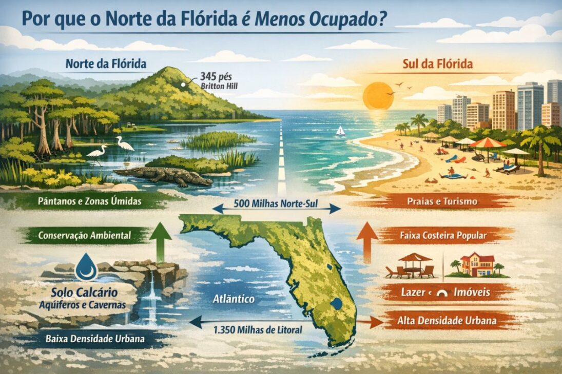
Florida has a very particular geography within the United States. Its peninsula shape, low altitude, limestone soil, the simultaneous presence of the Atlantic and the Gulf of Mexico, and the enormous coastline have shaped not only the natural environment but also the way cities have grown.
-
Spain surprises the world by erecting 62 artificial dunes, mixing sand with natural remains of posidonia, and causing the structure to lose only 1.4% of its volume in 1 year.
-
With 16 Bulava missiles, improvements in acoustic stealth, and a design focused on silent patrols, Russia’s nuclear submarine was born to ensure Moscow’s invisible retaliation and has become one of the pillars of its maritime strength.

-
‘Populous’ city in Rio among the worst in Brazil in national ranking and exposes silent development crisis.
-
Couple buys house in the South Zone of São Paulo, opens a hidden door in the garage, and finds a secret wine cellar with dozens of old wines forgotten since the 1970s.

The state stretches about 500 miles from north to south and 460 miles from east to west, but despite this size, it is predominantly low, with a maximum point of only 345 feet above sea level, in Britton Hill, in the Panhandle.
This physical condition produces direct effects on human occupation. Florida has about 1,350 miles of coastline, the longest among the contiguous states in the country, but coastline does not automatically mean the same type of utilization everywhere.
In the extreme north and northwest, the landscape is marked by swamps, wetlands, mangroves, and flooded areas, while the imagery associated with the south is much more linked to sandy beaches, coastal leisure, and tourism-oriented urbanization.
The difference between these environments is quite significant. Northern Florida retains ecologically valuable areas, with marshes, estuaries, and wetlands that protect the coast, sustain habitats, and help balance the water system.
However, this type of territory, although environmentally essential, does not offer the same visual, recreational, and real estate appeal that has propelled other parts of the state. Practically speaking, this means less pressure for intense urbanization, less attractiveness for those seeking a beach lifestyle, and less stimulation for a demographic boom comparable to that of the south.
Another important element is the relief and the geological composition of Florida itself. Much of the state rests on limestone, which favors the formation of sinkholes, springs, underground rivers, and aquifers. This system helped supply millions of people and sustain agriculture, but it also reinforced the complexity of occupation in various areas. The geography of Florida is not only beautiful or exotic; it acts as a silent force that defines where it’s easier to live, build, invest, and expand cities.
Ports, Commerce, And Tourism Shifted The Center Of Growth South To Florida
The population distribution of Florida has not only been shaped by nature. The economy has played a decisive role, and one of the central points of this difference lies in maritime infrastructure.
The Panhandle and other areas in the north have not historically had the same combination of natural ports, large navigable rivers, and transportation routes that have favored growth in other regions of the state.
This absence made a difference early on. While the south and part of west Florida could benefit from areas like Tampa Bay, Charlotte Harbor, and the Miami River, the north did not gather the same set of advantages. In regions where ports consolidate, commerce strengthens, transportation becomes cheaper, supply chains diversify, and cities begin to attract businesses, workers, and new residents. In Florida’s case, this mechanism operated with much more force in the south than in the north.
There is also an important geoeconomic detail: the relative proximity to New Orleans and the large port system at the mouth of the Mississippi River reduced the historical need for a giant port in the eastern half of the Gulf of Mexico. This further weakened the possibility of the Panhandle becoming a major maritime hub comparable to the urban centers in the south. When this opportunity does not consolidate early on, the entire growth chain tends to slow down as well.
The result is clearly visible in the hierarchy of metropolitan areas. The Miami region leads with about 6.1 million people, followed by Tampa, with 3.2 million, and Orlando, with 2.7 million. Jacksonville, the main urban center in the north, follows with 1.6 million.
In the Panhandle, Pensacola has about 510,000 inhabitants, while Tallahassee, the state capital, has approximately 309,000. These numbers show that the issue is not the absence of cities in northern Florida, but rather the distance between its urban scale and the attraction force exerted by the south.
Orlando also helps to understand that not everything depends on being a port city. Its growth began supported by citrus orchards, gained momentum with the real estate boom of the 1920s, and was later reinforced by the entertainment industry and proximity to the Kennedy Space Center. In other words, when Florida found a consistent economic axis, the population followed. The north, with fewer accumulated advantages, never repeated this same leap widely.
The History Of Florida Left Deep Marks On The Way The State Was Occupied
The history of Florida began long before its modern urban explosion. Before the European arrival, the region was inhabited by several indigenous peoples, including groups such as the Apalachee, Timucua, Calusa, and Tequesta.
The presence of these peoples shows that the area already had significant human and territorial importance long before being incorporated into colonial projects. But the arrival of Europeans, starting in the 16th century, radically altered this balance.
In 1513, Juan Ponce de León explored the east coast and named the land La Florida. Later, Spain would establish St. Augustine, in 1565, the oldest continuously inhabited European settlement in the territory that today comprises the United States. From then on, Florida was disputed by European powers, going through conflicts with the British, colonization difficulties, indigenous resistance, and even the severe effects of the climate itself, with hurricanes destroying fleets, plantations, and settlements.
This historical sequence helps to understand why Florida developed in layers and not in a homogeneous way. During the 17th and 18th centuries, the territory was the target of disputes between Spain and Great Britain.
In 1763, the British took control, but Spain regained the region in 1783. Only in 1821, after the Adams-Onís Treaty, did the United States officially acquire Florida. In 1845, the territory was admitted to the Union as the 27th state. Each of these political changes defined boundaries, priorities, and routes of occupation.
At the same time, the expansion of American settlers, new agricultural practices, and conflicts with Seminole peoples, which culminated in the Seminole Wars between 1817 and 1858, also influenced the spatial organization of the state.
Agriculture, especially the cultivation of cotton and citrus fruits, gained prominence in certain areas, but this was not enough to distribute growth evenly throughout Florida. The south would end up gathering, over time, more powerful conditions to concentrate capital, infrastructure, and population.
The Panhandle Is In Florida, But Has Never Occupied The Same Place In The Economic Imaginary Of The State

A natural question arises when observing the map: why does the Panhandle belong to Florida and not Alabama? The answer lies in treaties, territorial negotiations, and decisions consolidated in the early 19th century. The area was part of the so-called West Florida under Spanish rule, and its borders fluctuated as disputes and international agreements were made. When the United States took control of the region, the Panhandle was incorporated into Florida’s territory.
The Adams-Onís Treaty, signed in 1819, was central to this process by defining the boundaries that included the Panhandle within Florida. When the territory became a state in 1845, this configuration was maintained. Alabama, which had already become a state in 1819, did not decisively contest this division. Thus, Florida’s possession of the Panhandle was legally and politically consolidated, even though, in cultural and spatial terms, the region has maintained characteristics quite distinct from the peninsula further south.
This helps explain the frequent feeling that there are “two Floridas” coexisting within the same map. The Panhandle is more similar in atmosphere and occupation to the southern interior of the United States, while southern Florida has become more cosmopolitan, tropical, and connected to international migration flows. The political unity of the state has not erased the historical and geographical differences between its parts.
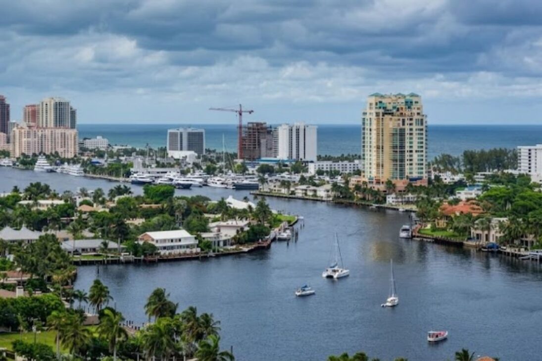
These distinctions became even clearer over time. Southern Florida benefited from a climate more consistently warm throughout the year, an important factor for retirees and for people seeking a lifestyle associated with the sun. Furthermore, the climatic and cultural proximity to the Caribbean, Central America, and South America reinforced the choice of cities like Miami for many migrants. It is no coincidence that Miami gained prominence as one of the largest urban and economic centers in the country and solidified its international image much more intensely than any city in northern Florida.
Why Does Northern Florida Continue To Have Fewer Residents Even Though It Is Part Of The Same State?
When geography, economy, climate, and history are combined, the picture becomes clearer. Northern Florida is not empty by chance, nor has it become less populated for a single isolated reason. The region has accumulated important natural limitations for large-scale urbanization, lost prominence in port infrastructure, received fewer economic stimuli over time, and has never concentrated the same tourist appeal as the south.
This does not mean an absence of relevance. Jacksonville is a significant economic center, with a port, diverse activity, and an active cultural life. Tallahassee serves a political function as the state capital. Pensacola holds regional importance. But collectively, these cities have not managed to draw the same volume of investment, migration, and urban expansion to the north as seen in Miami, Tampa, and Orlando. The scale difference objectively illustrates this.
Today, North Florida encompasses about 18% of the state population, around 3.9 million people. This figure summarizes decades of uneven development. The south has turned into an economic, tourist, and migratory showcase, while the north has remained more conditioned by its natural barriers and more contained development. The long coastline alone has never been enough to equalize the two halves of the state.
In the end, Florida challenges the notion that heat, sea, and beautiful landscapes are enough to spread the population evenly. The human map of the state was drawn by the combination of what nature allowed, what the economy rewarded, and what history cemented. And it is precisely for this reason that the north remains much less populated than the south.
Florida may appear as a single state on the map, but its occupation tells very different stories between the north and the south. And for you, what factor weighs more in this inequality: geography, economy, climate, or historical decisions? Is nature more valuable or is it the direction that development has taken?


Seja o primeiro a reagir!