 Portuguese
  English
  Spanish
In A Historical Discovery, Scientists Unravel The Oldest Map In The World On A 3,000-Year-Old Babylonian Tablet, Pointing To The Possible Location Of The “Ark Of Noah”. Learn More About This Surprising Find!
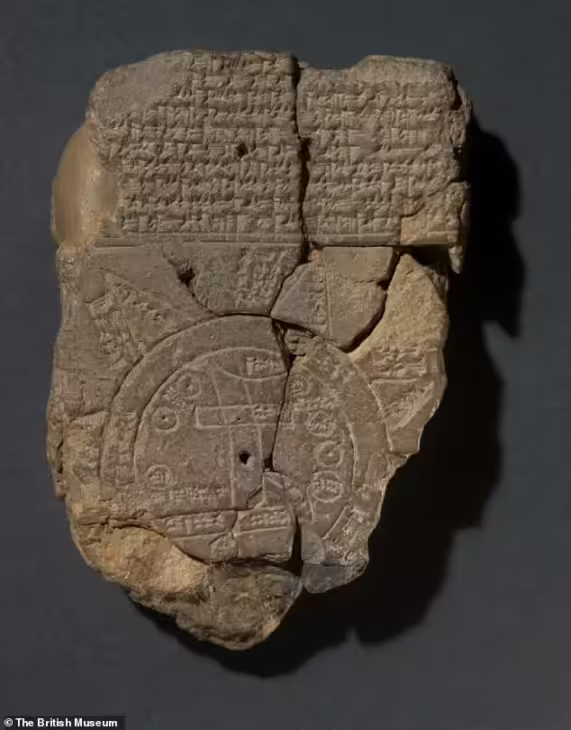
The discovery of an ancient Babylonian clay tablet, inscribed around 3,000 years ago, shed new light on the Ark of Noah. Scientists from The British Museum deciphered what appears to be the oldest map in the world, the Imago Mundi, an artifact that reveals details of the ancient understanding of the universe and, surprisingly, references to a monumental boat.
This “world map” is at the center of a study that connects stories from Mesopotamia with biblical accounts, providing a fascinating insight into the beliefs and events of the time.
The Meaning Of Imago Mundi
This map, inscribed in cuneiform — Babylonian writing that used wedge-shaped symbols — displays a circular diagram, with ancient Mesopotamia at the center. Surrounding it is represented a “bitter river” which, according to beliefs of the time, encircled the known world.
-
He started running at 66 years old, broke records at 82, and is now a subject of study for having a metabolic age comparable to that of a 20-year-old, in a case that is intriguing scientists and inspiring the world.

-
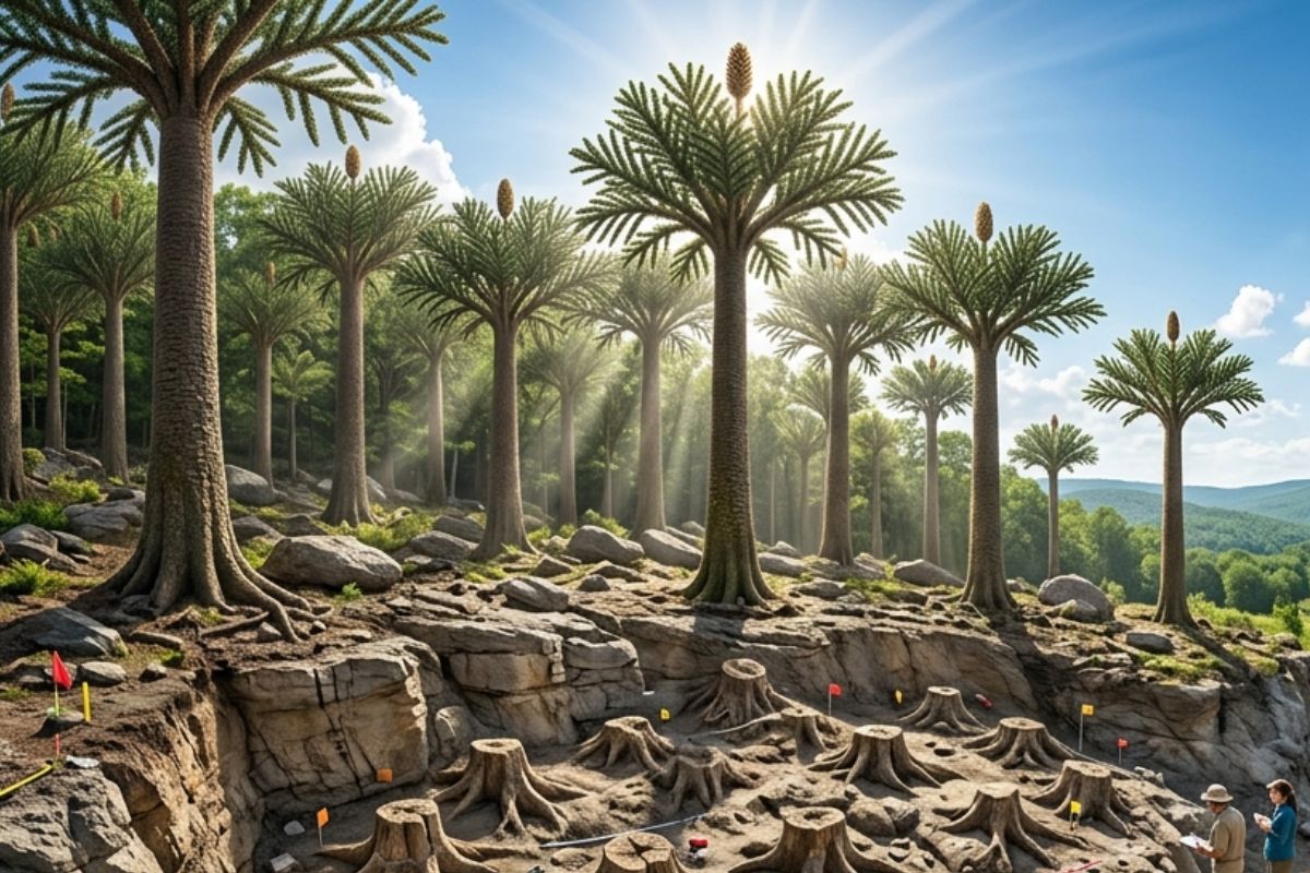
Oldest tree on the planet reappears after 130 years of searches: Wattieza, 385 million years old, was 10 meters tall and had no leaves or seeds; Gilboa fossils in New York solved the mystery in 2007.
-
A 48-square-meter house assembled in hours with 4,000 bricks made of recycled plastic that does not absorb moisture, has natural thermal insulation, and costs less than 90,000 reais in a complete kit.

-
Luciano Hang revealed that Havan’s air fleet has already accumulated more than 20,000 landings, 10,000 flight hours, and 6 million kilometers traveled, and he says that without the planes, the company would never have grown so quickly.


In its eight triangles, researchers suggest the representation of mountains, linked to references of a journey mentioned on the reverse of the tablet.
According to Dr. Irving Finkel, curator at The British Museum, the reverse of the tablet serves as a sort of guide for an expedition, instructing the traveler to cover “seven leagues” until they see an object as large as a boat, described as parsiktu — a term found in other Babylonian records indicating something akin to a boat intended for survival in a flood.
The Journey To Urartu: A Possible Parallel With The Bible And The Ark Of Noah
The instructions on the tablet lead researchers to a region known as Urartu, equivalent to the biblical term “Ararat,” where the Ark of Noah is said to have rested after the flood. In the biblical account, Noah and his family survived the cataclysmic event, with their vessel grounding on the “mountains of Ararat” in Turkey.
The parallel between the Babylonian and biblical stories becomes evident. According to Finkel, the Imago Mundi suggests that the Babylonians regarded this narrative as a historical fact. “If anyone followed the indicated route, they would see the remains of a monumental boat, similar to what is described in the Bible,” explains the researcher.

Ark Of Noah – A Babylonian Viewpoint On The Flood
In the Babylonian context, the flood story has roots in the Epic Of Gilgamesh, an epic poem where the god Ea warns Utnapishtim, the “Babylonian Noah,” about a great flood. Utnapishtim then builds an ark to save his family and the animals. The term parsiktu is used to describe the sturdiness of this vessel.
Finkel points out that the Imago Mundi is one of the few records that describe a “parsiktu vessel.” This coincidence has fascinated experts as it suggests a direct link between the Mesopotamian narratives and the biblical flood story. The researcher further states that the tablet describes the procedures for building the ark, which strengthens the connection between the cultural and religious traditions of Mesopotamia and the biblical texts.
The Controversy Surrounding Mount Ararat
Despite the excitement over the discoveries, Mount Ararat has sparked heated discussions among scientists and religious individuals. The literal interpretation that the ark rests on Ararat is questioned. Dr. Andrew Snelling, a young Earth creationist, argues that Mount Ararat is a more recent geological formation that emerged after the flood described in the accounts. According to Snelling, the chronology of the mountain’s formation would invalidate the location of the ark on Ararat.
However, a team of experts from Istanbul Technical University, led by geologists, has been exploring Mount Ararat for years. In 2023, this team revealed evidence that humans may have inhabited the area about 3,000 to 5,000 years ago, based on remnants of clay and marine materials found at the site.
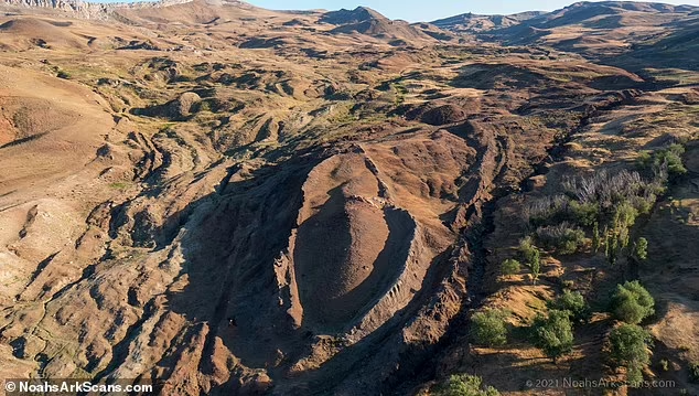
Geological Evidence And The Persistence Of The Myth
Another point of discussion is the peculiar formation of a structure that some believe to be the base of the ark. Studies indicate that the biblical ship would have immense dimensions: 300 cubits in length, 50 cubits in width, and 30 cubits in height, which would be approximately 515 feet in length and 86 feet in width.
Some scientists, however, argue that these dimensions may have been influenced by natural geological formations.
The geologists at Istanbul Technical University identified a peak that resembles the shape described for the ark, fueling speculations that an artificial structure may be hidden there.
The presence of clay and remnants of marine materials continues to challenge scientists as they attempt to determine whether this evidence is the result of human occupation or geological phenomena.
The Mythical And Historical Bases Of The Flood
Although the story of the biblical flood has been known for thousands of years, the discovery of the Imago Mundi adds a new layer to the understanding of this event. On one hand, the Babylonian account reinforces the biblical narrative; on the other, it highlights how different cultures share similar themes about creation and the preservation of humanity.
Scholars consider the Flood of Gilgamesh and the biblical flood to be representations of common cultural events, transmitted through generations and reimagined by the civilizations that composed ancient Mesopotamia. In clay tablets from that time, there are frequent mentions of natural disasters and calamities, suggesting that these stories may be interpretations of real geological events, such as major floods.


Seja o primeiro a reagir!