 Portuguese
  English
  Spanish
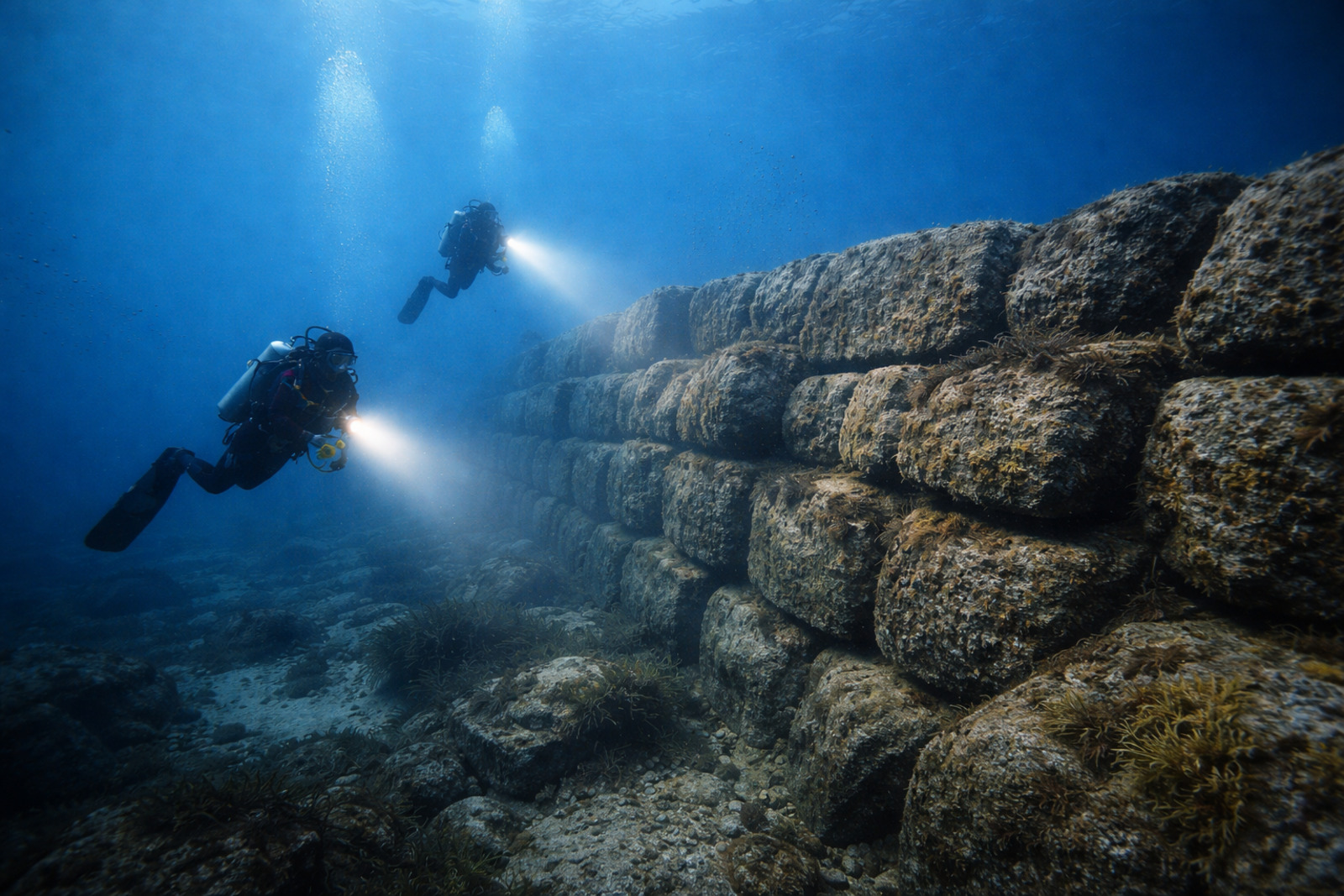
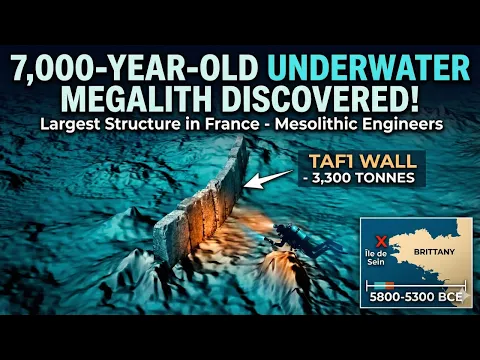
Confirmed in France, the 7,000-year-old submerged wall is 120 meters long, weighs 3,300 tons, and expands the debate on ancient coastal communities
The submerged wall near the Island of Sein, France, was confirmed in December 2025 as the largest prehistoric underwater structure ever identified in the country, measuring 120 meters in length, weighing 3,300 tons of granite, and being significant for the study of ancient coastal communities.
Discovery near Brittany
The submerged wall lies in the Atlantic, near the Island of Sein, at the western tip of Brittany, at a depth of 9 meters. The find was confirmed in December 2025, after years of study.
The initial identification occurred in 2017. Retired geologist Yves Fouquet was analyzing ocean floor maps when he found geometric anomalies that deviated from the natural landscape and indicated an organized formation.
-
Scientists have discovered a gigantic magnetic anomaly hidden beneath the soil of Australia that mirrors the shape of the entire continent and holds geological records of two and a half billion years that could change what we know about the Earth.

-
The heatwave that has been affecting Brazil in recent weeks is coming to an end: a cyclonic vortex is moving in during Holy Week with heavy rains, and a cold air mass is already threatening to lower temperatures in the South starting in April.

-
(VIDEO) Cameras from an astronomical observatory captured two meteors falling over Santa Maria in Rio Grande do Sul with only a one-minute difference and such close trajectories that scientists are now investigating whether the two objects have the same origin.

-
Fireballs shoot across the skies of the USA and meteor explosions draw attention: what is causing this mysterious wave of sightings?


The data from this stage came from LIDAR technology, used to map the terrain with high precision. The readings revealed shapes incompatible with natural processes and paved the way for archaeological investigation.
Fieldwork confirmed the structure
The physical confirmation of the submerged wall occurred between 2022 and 2024. The team from the Société d’Archéologie et de Mémoire Maritime conducted explorations to validate what had been detected on the maps.
There were 59 dives in the area of geological interest. In total, the professionals spent about 35 hours submerged, recording images, documenting the structure, and mapping the granite formation on site.
In addition to the main block, researchers identified another 11 smaller human-made structures in the same vicinity.
The set increased the relevance of the find and showed that the submerged wall is not isolated.
The work required technical effort from the divers. The operation served to transform a suspicion recorded on screen into a clear material confirmation, with documentation of the rock formation and its surroundings.
Size and weight impressed researchers
The main block was given the technical name TAF1, an abbreviation of Toul ar Fot, a Breton expression meaning “Wave Hole.”
The designation came to identify the main structure of the complex found on the seabed.
The submerged wall is 120 meters long. Its base reaches up to 20 meters wide, while the average height of the rocky blockage remains around 2 meters along the continuous stretch.
Researchers estimate that the total weight of the construction reaches 3,300 tons of granite. The volume of displaced material raises questions about the techniques mastered by ancient communities to organize stones on this scale.
Dating and investigated functions of the wall
The official dating placed the construction of the complex between 5,800 and 5,300 B.C. The stones were positioned centuries before Stonehenge and millennia before the pyramids of Giza, expanding the chronological dimension of the find.
At that time, the sea level was about 7 meters lower than it is today. The region functioned as an inhabited coast, a condition that helps explain the construction of a barrier.
Researchers are working with two main hypotheses for the function of the submerged wall. One suggests it was used as a fish trap, directing schools into shallow areas where they became trapped during low tide.
The other hypothesis considers that the structure could act as a protective dyke for coastal communities against the gradual rise of the waters. Both lines remain at the center of investigations into the original utility.
Debates about the legend of Ys
The exact location of the wall has reignited debates about the Celtic legend of the city of Ys in Brittany.
The account speaks of an ancient metropolis swallowed by the waves at a point located just a few kilometers from the discovered structure.
The find also reinforces the idea that the ocean preserves important remnants of ancient human occupations.
The submerged wall shows that the seabed still holds evidence capable of rewriting the view of these coastal societies.
With information from Revista Oeste.


Seja o primeiro a reagir!