 Portuguese
  English
  Spanish
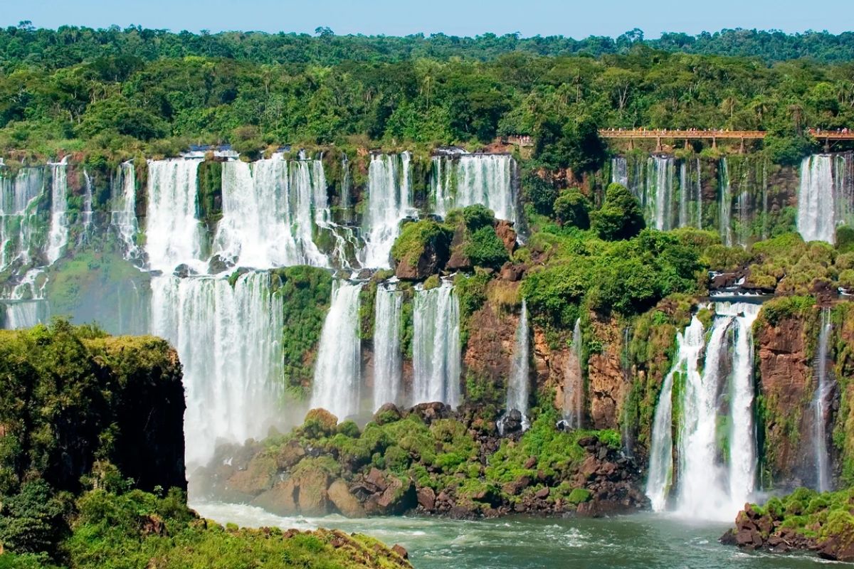
Natural Wonders Combine Geology, Water, and Time: In National Park, UNESCO Records Rice Terraces at 700 to 1,500 Meters Altitude, Carbonate Lakes, and Nearly One Kilometer Waterfall, While Plates Drift Apart 2 Cm Per Year and Reshape Continents With Rare Fauna, Valleys, and Mineral Colors.
In the realm of natural wonders, some patterns repeat: areas in national parks, UNESCO records, high altitude environments, and waterfalls that become references by scale. The itinerary below gathers ancient agricultural landscapes, lake systems, mountains, and tectonic fissures described with measurements and historical landmarks.
Among these natural wonders, diversity does not eliminate precision. There are rice terraces over 2,000 years old, lakes connected by waterfalls, mountains with flat tops above the Atlantic, and a valley where tectonic plates separate by 2 cm per year. Commonly, an inventory of numbers, places, and species appears.
Rice Terraces in Luzon: 700 to 1,500 Meters Altitude and Irrigation by Earth and Stone

In the rice lands of the Philippines, on the island of Luzon, the ensemble was recognized by UNESCO in 1995.
-
7.8 magnitude earthquake in Indonesia frightens the population, triggers tsunami alert, and hits an island with over 200,000 inhabitants this Thursday.
-
Google will finally let you change that embarrassing Gmail address you created in your teenage years without losing any accounts, logins, or old emails: the feature is already available in the United States.

-
Heading to Brazil in a Bonanza F33 single-engine aircraft: a couple departs from Florida on a visual flight, makes technical stops in the Caribbean to refuel and organize paperwork, and begins the staged crossing until they reach the country.

-
Unknown Brazilian rewrites one of the pillars of physics and gains global prominence: discovery made in Rio becomes central theme of the 2027 Nobel Prize.

The description indicates an altitude between 700 and 1,500 m above sea level and terraces over 2,000 years old, built entirely by hand.
During harvest time, the terrain transforms into a golden carpet that blends into the clouds.
The irrigation system channels water from the forests to each field using earth and stone.
In addition to the landscape, the area is associated with rice planting rituals, wooden houses with thatched roofs, and folk dances.
The tropical rainforest ecosystem surrounding it includes rare birds, monkeys, and aromatic traditional rice.
Plitvice Lakes National Park: 16 Lakes, 189 Km², and Calcium Carbonate Deposition

The National Park of Plitvice Lakes in Croatia is described as a system of 16 lakes connected by waterfalls.
This formation is attributed to calcium carbonate deposition over thousands of years, creating crystal-clear waters with multiple shades.
The area covers about 189 km² and was recognized by UNESCO as a world heritage site in 1979.
The fauna includes brown bears, wolves, and more than 160 species of birds.
The surrounding vegetation is described with over 1,200 plant species, from ancient pines and oaks to wildflowers like orchids and bellflowers.
On the trail, one waterfall leads to another, connecting lakes and observation paths.
Angel Falls: 979 Meters Total and 806 Meters of Direct Drop
The Angel Falls, also known as Salto Angel, is described as the highest uninterrupted waterfall in the world.
The indicated total height is about 979 m, with a direct drop of approximately 806 m.
During the rainy season, the flow is described as powerful and noisy; in the dry season, the water becomes thinner and exposes vertical cliffs.
The indigenous name Pemon mentioned is “Kerepakupai Merú,” translated as waterfall of the deepest place.
The surroundings include towering trees, vines, and ferns, forming a green curtain nourished by the mist. Among the recorded fauna are the harpy eagle and flocks of macaws.
Table Mountain: 1,085 Meters, Over 3 Km, and Sandstone of 600 Million Years
Table Mountain in South Africa is described as having a flat top, 1,085 m high, and extending over 3 km, overlooking the Atlantic Ocean.
At its summit, there is mention of intense sunsets and the phenomenon of clouds covering the peak on humid days.
A rotating 360º cable car takes visitors to the top, revealing cliffs and green areas.
The formation is attributed to 600 million years of sandstone.
The mountain houses the fynbos ecosystem, with protea flowers and small “rock hyenas,” as well as eagles in flight.
Among the cited elements, altitude appears as a physical measure that organizes the terrain and the observation.
Thingvellir: Plates Drift Apart 2 Cm Per Year Within a National Park of 93 Km²
The Thingvellir National Park is located in southwestern Iceland, approximately 40 km east of Reykjavik.
The highlight is the fissure valley where the tectonic plates of North America and Eurasia separate.
The movement is described at an approximate rate of 2 cm per year.
The Silfra fissure is mentioned as a spot where visitors can dive between two continents in crystal-clear waters from glacial melt.
Lake Tingvalavatn, described as the largest in Iceland, is also within the national park.
The area covers about 93 km², was established in 1930, and was designated by UNESCO in 2004.
Vinicunca: 5,200 Meters Altitude, Iron Oxide, and Chlorite in the Colorful Stripes
The rainbow mountain, known as Vinicunca, is described in Peru at about 5,200 m of altitude.
The colorful stripes are attributed to minerals, including red from iron oxide, yellow from iron sulfide, and green from chlorite.
Before 2015, the mountain was covered by glaciers; melting exposed the layers.
The environment is described with a harsh climate, without large trees, and low vegetation like ichu grass.
To get there, the description indicates driving for several hours from towns and following on foot along rugged and dusty trails.
Parícutin: 1943 to 1952, 424 Meters in 9 Years, and Lava Covering 230 Km²
The Parícutin volcano in Mexico is described as the youngest in the world.
It is said to have emerged in 1943 in a cornfield, reached 424 m in just 9 years, and ceased in 1952.
It is situated on a plateau of 2,800 m of altitude, with black lava extending over more than 230 km².
The account highlights that scientists witnessed the entire life cycle of the volcano, from the opening of the ground and ash emission to the final silence.
The mentioned date is February 20, 1943, when a farmer reportedly saw the formation, with residents fleeing as the lava advanced.
A mentioned visual detail is a church steeple emerging from the black rock.
Iguaçu: 2.7 Km Wide, 82 Meters High, and 1.9 Km Trail
The Iguaçu Falls are described as one of the largest waterfalls in the world, with a width of about 2.7 km and main drops of up to 82 m in height.
The cited volume is about 1,760 liters of water per second.
The area is described as lush tropical rainforest, home to over 400 species of animals and more than 2,000 species of plants.
Among the rare species mentioned is the blue macaw.
The recorded indication is an average of 100 mm of rain per year.
A walking path extending 1.9 km allows access to see smaller falls and surrounding lakes, reinforcing the direct observation of these natural wonders.
For those following natural wonders out of curiosity or travel planning, the most realistic step is to separate each destination by access requirements: high altitude, long trails, and parks with specific rules completely change the logistics. Which of these natural wonders would you place at the top of your list first?


-

-

-

3 pessoas reagiram a isso.