 Portuguese
  English
  Spanish
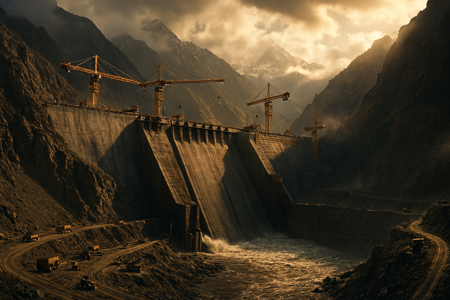
Recent Analyses Indicate That Thousands of Dams in the United States, Many Over 50 Years Old, Show Structural Damage, Maintenance Failures, and Design Limitations, While More Frequent Extreme Weather Events Increase the Risk of Breaches, Sudden Flooding, and Direct Impacts on Populations, Urban Infrastructure, and Water and Energy Supply Systems
Thousands of Dams in the United States are old, show structural damage, and were not designed to withstand extreme weather conditions, according to recent analyses based on satellite images, which indicate failure risks greater than those identified by traditional inspections.
Satellite images revealed that dozens of dams in the United States, including the largest one in Texas, may be at risk of collapse due to shifting ground beneath their foundations. Conventional inspections typically do not consider these displacements, suggesting that many structures are in worse condition than previously estimated.
The findings raise the possibility that thousands of dams that are not closely monitored due to high costs and a shortage of technical personnel may be damaged and at risk of breaching. The scenario reignites the debate about the real extent of the problem and the use of satellite data as an early warning tool.
-
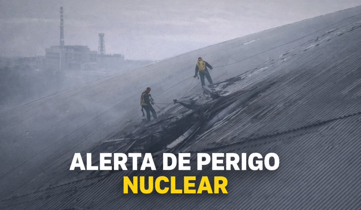
The gigantic steel shell built to contain Chernobyl for a century has been pierced by a drone, exposing a critical system and creating a hole that could cost over 500 million euros to repair.
-
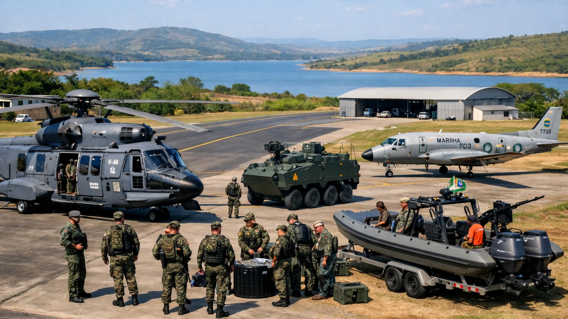
Brazilian Navy reaches a new level by taking over an airport with a 1,600-meter runway used by 1,800 military personnel and autonomous attack drone testing.
-
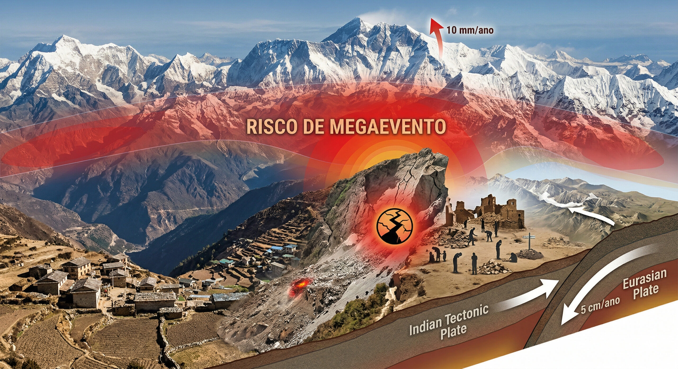
The Himalayas continue to grow to this day, with tectonic plates advancing 5 cm per year, mountains rising up to 10 mm annually, and the 2015 earthquake that killed 9,000 people may have increased the risk of an even larger seismic mega-event.
-
At an altitude of 400 km by astronauts from the International Space Station, Paris transforms at night into a golden mesh so precise that it reveals the outline of the Seine River, avenues, and entire neighborhoods like a luminous map drawn over the Earth.


Experts stated that satellites can provide a relatively simple way to monitor dams, identifying locations where ground movements are destabilizing the structure. At the same time, the data highlight an additional challenge, as climate change increases the risk of failures in aging dams across the country.
“Identifying problems in dams is crucial to prevent failures,” said John Roche, dam regulator in Maryland and president of the Association of State Dam Safety Officials. According to him, the lack of timely rehabilitation, combined with increasing climate stress, heightens risks to public safety, economic impacts, and environmental damage.
Satellite Monitoring and Ground Displacements
In a presentation made to the American Geophysical Union in December 2025, scientists used ten years of radar images from the Sentinel-1 satellite to identify dams that have experienced shifts caused by ground subsidence or uplift. Depending on the materials of the dam, these movements can cause structural cracks.
The risk increases when different parts of the structure move in opposite directions or at different speeds. Under these conditions, the integrity of the dam can be compromised gradually, without immediate visible signs during routine onsite inspections.
“This technology helps us find potential problems and then inform the responsible parties,” said lead researcher Mohammad Khorrami, post-doctoral geotechnical engineer at Virginia Tech and the United Nations University Institute for Water, Environment, and Health.
The study analyzed 41 hydropower dams classified as high risk, over 50 feet tall, and rated as “poor” or “unsatisfactory” by the National Inventory of Dams. These structures have known defects that compromise operational safety and require repairs.
The results are still preliminary and have not been peer-reviewed. Nevertheless, they point to previously unknown vulnerabilities in dams located in 13 U.S. states and Puerto Rico, including the Roanoke Rapids Dam in North Carolina and the Livingston Dam in Texas.
Some of these dams are experiencing what are considered significant displacements. At the Livingston Dam, the northern section is sinking at an approximate rate of 8 millimeters per year, while the southern section rises simultaneously at the same rate.
This dam supplies two water treatment plants that provide drinking water to over 3 million people in the Houston area. The differential ground movement raises additional concerns due to the importance of the system for urban supply.
Khorrami emphasized that the data do not indicate that part of the dam is collapsing. However, the differences in elevation warrant further investigations, as they may signal structural problems in aging and potentially defective dams.
Given that many of these structures have been in existence for decades and affect both downstream communities and power generation, accumulated deformations can lead to severe consequences. In extreme cases, structural failures can cause rapid and large-scale flooding.
International Examples and Recent Lessons
An incident that occurred in Libya in 2023 illustrates why ground elevation changes should not be ignored. On September 11 of that year, two dams failed after extreme rain associated with Storm Daniel.
The breaches released about 30 million cubic meters of water, equivalent to 10,000 Olympic-sized swimming pools, onto the city of Derna. The flow destroyed buildings and bridges and resulted in the deaths of up to 24,000 people, according to estimates reported at the time.
A study published in 2025 concluded that deformations in the dams, caused by changes in ground elevation, likely contributed to the collapses. Satellite images showed constant and persistent deformation in both structures over the past decade.
“Therefore, these dams were already vulnerable,” Khorrami said in commenting on the results. According to him, the case demonstrates the importance of identifying warning signs before extreme weather events occur.
Khorrami and his colleagues are finalizing the results of their study in the United States. The next step involves creating a map or interactive database that can be used by policymakers to assess dam safety on a national scale.
The researcher emphasized that satellite monitoring does not replace onsite inspections. The proposal is to provide an additional tool capable of indicating early alerts when there are signs of structural problems or potential risks.
Aging Infrastructure and Urban Expansion
Ground displacements are just one of the factors threatening the safety of dams. The United States has nearly 92,600 dams, of which over 16,700 are classified as having high potential risk, according to the Association of State Dam Safety Officials.
This classification indicates that a potential collapse could result in loss of life and significant destruction of property. Most of these dams were designed over 50 years ago, and about 2,500 show signs of damage that would require billions of dollars in repairs.
While some structures are large hydropower dams, thousands are small watershed dams. They were built to prevent flooding, provide drinking water, and preserve wildlife habitats in various regions of the country.
When many of these dams were built in the 1960s and 1970s, there was little human occupation in the surrounding areas. Over time, communities grew around these structures, significantly increasing the potential for damage in the event of a breach.
Currently, a collapse could directly affect residential areas, roads, water supply systems, and energy infrastructure. This scenario has amplified the importance of more detailed and frequent risk assessments.
Moreover, the dams were designed for specific environmental conditions at the time of their construction. Since then, global warming and changes in land use have altered hydrological patterns in various regions.
Some rivers show reduced flow due to prolonged drought, while others register higher water levels than they did 50 or 60 years ago. Increased intense rainfall and urbanization reduce the soil’s infiltration capacity, raising the volume of surface runoff.
According to Ebrahim Ahmadisharaf, assistant professor of civil and environmental engineering at Florida State University, these changes increase pressure on dams that were not designed for such conditions. He did not participate in the satellite study but commented on the associated risks.
The climate has also become more extreme and unpredictable, raising the probability of sudden flooding. Intense rain events can quickly push water levels above the capacity of the dams’ spillways.
Increasing Risk of Overflow
In a 2025 study, Ahmadisharaf and his colleagues analyzed the likelihood of dam overflow over the past 50 years. Overflow occurs when the water level exceeds the capacity of the spillways and flows over the dam.
The study identified an increase in this risk in 33 dams during the analyzed period. The phenomenon is considered one of the most dangerous failure mechanisms, as it can cause rapid erosion and loss of structural stability.
The dams with the highest likelihood of overflow were large structures located near population centers. Among them were the Whitney Dam in Texas, the Milford Dam in Kansas, and the Whiskeytown Dam in California.
The potentially affected areas include cities such as Waco, Texas, with about 150,000 residents, and Junction City, Kansas, with approximately 22,000 residents. In the event of a failure, the consequences could be severe.
“Overflow is a possible failure mechanism of a dam,” explained Ahmadisharaf. According to him, the larger the dam and the shorter the distance to the downstream population, the more dangerous the overflow becomes.
Ahmadisharaf also stated that satellite radar imagery could help assess overflow risks by providing more accurate estimates of water levels and flood extent, allowing for earlier alerts.
High Costs and Financial Limitations
One of the main obstacles to making dams safer in the United States is funding. The older the structures, the higher the operating, maintenance, and rehabilitation costs tend to be.
According to Roche, these costs can range from thousands to millions of dollars per dam. The financial responsibility falls on the owners, many of whom do not have sufficient resources to cover the necessary expenses.
The rehabilitation of only the dams considered most critical has been estimated at US$ 37.4 billion. This figure is likely to increase as maintenance is delayed, raising the risk of more severe structural failures.
The implementation of satellite monitoring also represents an additional cost. However, Roche stated that the investment may be justified if it helps prioritize repairs and prevent catastrophic failures.
A forensic report on the incident at the Oroville Dam spillway in 2017 showed that traditional inspections do not always identify relevant structural problems. The episode led to the evacuation of more than 180,000 people, without any recorded deaths.
With only preliminary results available, it is still challenging to assess the effectiveness of using satellite data to prioritize repairs. Nevertheless, Roche emphasized that the deformation of structures may indicate gradual deterioration.
David Bowles, a dam safety risk expert and emeritus professor at Utah State University, expressed caution regarding the conclusions. According to him, there are various ways in which a dam can fail.
In his experience, foundation settlement is not the primary cause of most breaches. Still, it can act as a contributing factor, especially if not monitored and managed properly.
Potential and Limits of Remote Monitoring
Despite the caveats, experts agree that satellites offer a broader view of the risks associated with dams than what is currently available. The ability to continuously monitor large areas is seen as a significant advantage.
Ahmadisharaf stated that it is not possible to monitor all dams exclusively through onsite inspections. In this context, the use of satellites expands coverage and allows for the identification of areas that need immediate attention.
Remote monitoring does not eliminate the need for detailed inspections, but it can guide strategic decisions about where to concentrate limited resources. For researchers, it is a complementary tool.
Overall, the data reinforces the severity of the challenge facing dam infrastructure in the United States. The aging of structures, combined with climate change and financial limitations, creates a scenario of increasing risk.
According to experts, the integrated use of traditional inspections, satellite data, and long-term planning will be essential for reducing the likelihood of failures and protecting downstream populations, even in the face of an increasingly unpredictable climate scenario.
This article was based on information from Live Science, the Association of State Dam Safety Officials (ASDSO), and the National Inventory of Dams.


-

Uma pessoa reagiu a isso.